Skip to content

Random Connections

A collection of photography and exploration focusing on Upstate South Carolina and beyond.

  • Home
  • About Us
  • Photos
  • Resources
  • Other Voices
  • Post Archives
  • Podcast
  • Home
  • Geocaching and Maps
  • Page 4

Category: Geocaching and Maps

0

The Journey Home from Olanta

Posted on September 26, 2015September 26, 2015 By Tom No Comments on The Journey Home from Olanta
Geocaching and Maps, History and Genealogy, Photography, Rambling

South Lynchburg Store Sepia

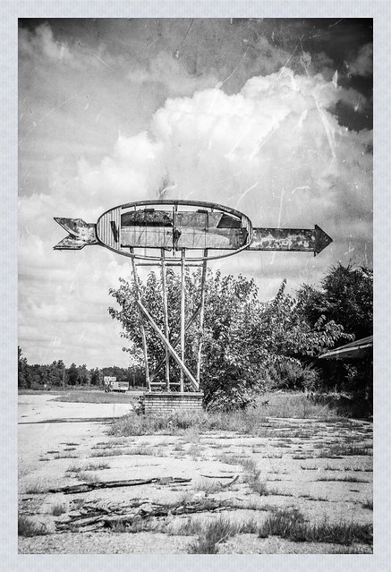
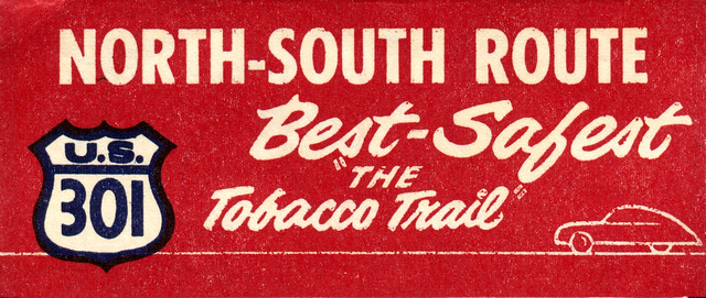
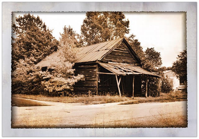
It had been a long day. I had gotten up early and driven down to Orangeburg, then followed the Tobacco Trail along US Highway 301 through Orangeburg and Clarendon Counties. I had crossed over into Florence County into the town of Olanta. I thought about pushing on to the town of Florence, but when I checked my GPS I saw that it was going to take several hours to get home as it was, so it was time to head back. Even so, I made a couple of stops and detours. These were interesting sights worthy of documentation, but I didn’t think they fit with the Tobacco Trail narrative.

Read More “The Journey Home from Olanta” »

Lunch on the Tobacco Trail at the Chat n Chew

Posted on September 25, 2015September 25, 2015 By Tom 1 Comment on Lunch on the Tobacco Trail at the Chat n Chew
Geocaching and Maps, History and Genealogy, Photography, Rambling, Restaurants

Chat-N-Chew Sepia

I do my homework before I go out on these extended photo expeditions. I like to know what’s in an area so that I make sure I can get to my intended target. Sure, I miss things. There were lots of things I had to skip on this particular trek. Sometimes I find too much, and those extra places of interest become distractions from my intended target. Sometimes, though, things work out perfectly, as was the case with lunch at the Chat n’ Chew in Turbeville on this particular trek.

Read More “Lunch on the Tobacco Trail at the Chat n Chew” »

The Tobacco Trail through Clarendon County

Posted on September 25, 2015 By Tom 4 Comments on The Tobacco Trail through Clarendon County
Geocaching and Maps, History and Genealogy, Photography, Rambling

Motel Featherbed

I had come to a roadblock on the Tobacco Trail, quite literally. The Highway 301 bridge across Lake Marion still exists, and still connects across the lake. However, in 1987 it was closed to automotive traffic, and now serves as a fishing bridge. If I were going to cross from Orangeburg into Clarendon County, I was going to have to do some backtracking.

Read More “The Tobacco Trail through Clarendon County” »

The Rise of Santee on The Tobacco Trail

Posted on September 22, 2015September 26, 2015 By Tom 1 Comment on The Rise of Santee on The Tobacco Trail
Geocaching and Maps, History and Genealogy, Rambling

Tobaco Trail-3

For some reason the town of Santee intrigues me. It’s something of an anomaly compared to the other cities on the Tobacco Trail. There is no main street or central business district. Those features make me think that the town as, say, Orangeburg, Allendale or Bamberg. I decided to find out more about it. In the process of that research I discovered a new ghost town.

Read More “The Rise of Santee on The Tobacco Trail” »

The Tobacco Trail through Orangeburg County, Part 2

Posted on September 20, 2015February 1, 2020 By Tom 14 Comments on The Tobacco Trail through Orangeburg County, Part 2
Geocaching and Maps, History and Genealogy, Photography, Rambling

Tobaco Trail-1

I was out exploring the Tobacco Trail through South Carolina. So far I had started at the SC-GA border on the Savannah River and had crossed Allendale, Bamberg, and a good portion of Orangeburg Counties. Orangeburg is a large county, and is bordered by Lake Marion on the east. I was ready to check out the rest of the county, and see how far I could go on this day’s exploration.

Read More “The Tobacco Trail through Orangeburg County, Part 2” »

The Tobacco Trail through Orangeburg County, Part One

Posted on September 18, 2015September 23, 2015 By Tom 3 Comments on The Tobacco Trail through Orangeburg County, Part One
Geocaching and Maps, History and Genealogy, Photography, Rambling

Coffee Cafe B&W

So far I had traveled across two South Carolina counties on The Tobacco Trail, aka US Highway 301. I still had a long way to go, though. I was able to get through about a third of Orangeburg when we had a death in the family. Yesterday I was able to go knock out another huge chunk of the highway.

Read More “The Tobacco Trail through Orangeburg County, Part One” »

The Tobacco Trail through Bamberg County

Posted on September 13, 2015September 13, 2015 By Tom 4 Comments on The Tobacco Trail through Bamberg County
Geocaching and Maps, History and Genealogy, Photography, Rambling

Bamberg Service Station Sign

I’d made it through Allendale County, my GPS beeping every time I reached the location of an old tourist spot that I had marked. I was following the Tobacco Trail through South Carolina on Highway 301. Now I had just crossed the Salkehatchie River into Bamberg County.

Read More “The Tobacco Trail through Bamberg County” »

The Tobacco Trail through Allendale County

Posted on September 11, 2015September 18, 2015 By Tom 5 Comments on The Tobacco Trail through Allendale County
Geocaching and Maps, History and Genealogy, Photography, Rambling

Crescent Motel Retro 1

I was out exploring Highway 301, the Tobacco Trail. I had driven down early in the morning, trying to resist distractions along the way. Once I finally reached my starting point I visited two old welcome centers, one still in operation, and one finding new life. Now it was time to continue eastward. However, my day was running out, and the trip was much quicker than I would have liked.

Read More “The Tobacco Trail through Allendale County” »

The Tobacco Trail – An Introduction

Posted on September 7, 2015September 7, 2015 By Tom 1 Comment on The Tobacco Trail – An Introduction
Geocaching and Maps, History and Genealogy, Travel

Highway 301 Banner

On our last Lowcountry Unfiltered kayaking trip on the Savannah River Larry Easler and I drove back along Highway 301.  We were amazed at the number of old motels and abandoned tourist spots along the way.  I knew it had to have once been a major thoroughfare, now bypassed by I-95, but I wanted to know more about it.  What was its history?  How did this highway through one of the most desolate parts of South Carolina become such a major route?  The answer turned out to be much more interesting than I could have possibly imagined.

In a previous post I wrote about the old auto trails that predated the US Highway System, and the business associations that promoted these routes and the tourist amenities along them. Here’s the story about how Highway 301 became known as The Tobacco Trail, one of the most important north-south routes along the Eastern Seaboard.

Read More “The Tobacco Trail – An Introduction” »

GeoPodcasting Revisited

Posted on February 28, 2015 By Tom 1 Comment on GeoPodcasting Revisited
Geocaching and Maps, Internet, Music, Podcast

Untitled

Back in 2007 I wrote an post entitled “Geopodcasting – Adding Location to Audio.” I had just given a talk at SC EdTech on geotagging, and the post was meant to explore the idea of geotagging audio files.

There have been lots of changes in the seven and a half years since that post came out. I wanted to revisit the subject and see what tools and options are now available for for adding location data to audio.

Back in 2007 photo geotagging was just taking off. It was (and still is, to some extent) a tricky process. Back then smart phones weren’t as prevalent, so not too many people had a hand-held device that could combine GPS, imagery, and audio. Today we have iPhones, Androids, and various tablets that can do all of this. So you would think that the process would be much easier. But is it?

Read More “GeoPodcasting Revisited” »

Posts pagination

Previous 1 … 3 4 5 … 21 Next

Categories

  • EdTech (197)
  • Entertainment (201)
  • Family (123)
  • Gear (114)
  • General Technology (98)
  • Geocaching and Maps (208)
  • History and Genealogy (275)
  • Internet (142)
  • Local (458)
  • Miscellaneous (559)
  • Music (202)
  • Paddling (267)
  • Photography (781)
  • Podcast (19)
  • Rambling (233)
  • Rants (162)
  • Recipes (37)
  • Religion (48)
  • Restaurants (165)
  • Science (48)
  • Things Overheard (29)
  • Travel (413)
  • Uncategorized (143)
  • Washington Sabbatical (113)
  • Weirdness (60)

Recent Posts

  • Exploring Lake Summit
  • The End of Days
  • Double-Dipping on the Edisto
  • Jerk Chicken a la Farehouse
  • How’s the House, Part 3

Recent Comments

  • Kathleen on A Stonecutter’s Tale
  • Karl Plenge on Exploring Lake Summit
  • Virginia Pepper on Exploring Lake Summit
  • John Guerrant on Carolina Ghost Towns – Merrittsville
  • Laura A Davenport on Brandon Mill Cemetery Clean-up

Tags

blogging cemetery Christmas Columbia Edisto River edtech Entertainment family Flickr Florida Furman Furman University gear Georgia geotagging Ghost Town Ghost Towns Google Earth Google Maps GPS Greenville Greenville Chorale history Instructional Technology kayaking Lake Jocassee LCU Lowcountry Unfiltered maps Music North Carolina Paddling Photography rambling restaurant Restaurants review singing social networking South Carolina time-lapse Travel video Washington Washington State
September 2025
S M T W T F S
 123456
78910111213
14151617181920
21222324252627
282930  
« Aug    

Copyright © 2025 Random Connections.

Theme: Oceanly by ScriptsTown