Skip to content

Random Connections

A collection of photography and exploration focusing on Upstate South Carolina and beyond.

  • Home
  • About Us
  • Photos
  • Resources
  • Other Voices
  • Post Archives
  • Podcast
  • Home
  • geotagging

Tag: geotagging

Google Maps Screws Up

Posted on July 21, 2013July 25, 2013 By Tom 1 Comment on Google Maps Screws Up
Geocaching and Maps, Rants

I’m not one of those people that mounts protests every time Facebook changes their layout, or when GMail makes some slight change. I even like the new updates to Flickr, even though some users are threatening to abandon it for Ipernity. So, when I say that Google Maps has really screwed up with their latest … Read More “Google Maps Screws Up” »

Geotagging “Threat”

Posted on March 4, 2011 By Tom No Comments on Geotagging “Threat”
Geocaching and Maps, Internet, Photography

Just when you thought it might be safe to let the kids out of the house, the news media comes up with even more scary stuff that you didn’t know about. This time geotagged photographs are the culprit. Two separate news outlets – MSNBC and ABC, have aired segments on the dangers of posting geotagged … Read More “Geotagging “Threat”” »

Flickr to Panoramio – One More Attempt

Posted on February 18, 2011 By Tom No Comments on Flickr to Panoramio – One More Attempt
Geocaching and Maps, Photography

I really want to contribute to Panoramio.  Really, I do.  I would love to have my photos show up in a native layer on Google Earth without having to use a third-party KML/KMZ file.  So I’ve been looking for work-arounds for their security problems and inability to upload more than 10 images at a time. … Read More “Flickr to Panoramio – One More Attempt” »

Rethinking Panoramio

Posted on February 17, 2011 By Tom 5 Comments on Rethinking Panoramio
Photography, Rants

Last post I was singing the praises of Panoramio for location-based photo sharing.  I’ve uploaded a bunch of photos, and had 250 approved for Google Earth.  I was quite flattered.  The selected photos included some of my best shots, and covered the entire US, from Florida to Maine, to Washington State. …and as of this … Read More “Rethinking Panoramio” »

From Flickr to Panoramio

Posted on February 16, 2011 By Tom 10 Comments on From Flickr to Panoramio
Geocaching and Maps, Photography

Google Earth Panoramio

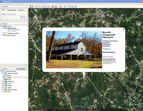
I finally caved in. I’ve been uploading some selected photographs to Panoramio so that they will appear in the Google Earth Photos layer.  As of this writing I have 121 photographs that have been selected to appear in Google Earth, and I’ve submitted more that are awaiting approval.

If you’ve got a Google account, then you can use that to sign into Panoramio and create an account.  Photos are uploaded just like they are to any other photo sharing site.  Just make sure that your photos are geotagged.  Even if they haven’t been geotagged previously, there is a drag-n-drop map so you can locate your photos once they have been uploaded.

Panoramio has some specific guidelines for approval for Google Earth.  There are the usual conditions – no pornography, discriminative, or abusive photos.  However, there are some other guidelines.  They are looking for photos that illustrate a place, so images of people, events, or detailed images of flowers or other items may not be approved.  Likewise, interior shots probably won’t be selected for Google Earth.

For Google Earth and Google Maps we select only photos about exterior places: landscapes, monuments, streets, buildings, parks, and so on. All photos must comply with the Panoramio Photo Acceptance Policy.

Read More “From Flickr to Panoramio” »

Test-Driving the Eye-Fi Explore

Posted on March 8, 2010 By Tom 2 Comments on Test-Driving the Eye-Fi Explore
Gear, Geocaching and Maps, Photography

Eye-Fi

I’ve been interested in these little gizmos for some time now. The Eye-Fi Explore is an SD card that will automagically upload your photos to your online photo service of choice whenever it comes within range of an open wireless network. Not only that, it uses some strange alchemy to geotag your photos each time you click the shutter. It sounded like the perfect photographic tool, but also the promises seemed too good to be true. I was hesitant to make the investment until I saw that Woot.com had one for a dirt-cheap price. I decided to give it a shot. I found it both to be about as amazing as I expected, and about as frustrating as I imagined.

Eye-FiThe Eye-Fi comes with the SD card (2 GB in my case, but available up to 8 GB) and a USB card reader, as shown above. The management software comes on the card itself, and automatically launches when the device is first plugged into the computer. The first thing I discovered is that you must have wireless access to configure the device. Just being connected to a computer with Internet access isn’t enough.

There are lots of parameters that can be set with the device. You can choose your photo hosting service (Flickr, in my case) and even set up separate routing for videos, so your photos may go to Flickr, but your videos to YouTube. You can set the device to connect and upload automatically to any wifi hotspot, or only when it comes within range of specified hotspots. I always like to edit my photos before they go public, so I set the privacy settings so that I would be the only one to see them on Flickr. You can also enable/disable geotagging.

Eye-Fi-Screen-Two

The most amazing thing is that this device actually works. I tried it in both my Fuji WP33 and my Nikon S70. It took photos, and when I turned the camera on in the presence of a wireless network, it uploaded the photos to my Flickr account without any interaction from me.

Read More “Test-Driving the Eye-Fi Explore” »

Seero – Geospatially Aware Video

Posted on May 12, 2008 By Tom No Comments on Seero – Geospatially Aware Video
Geocaching and Maps

In my discussions about geotagging, one of the questions that always arises is the issue what location should be tagged. If you’re tagging photographs, should you tag the location where you took the shot, or should you tag the location of the subject. For example, if you were standing on an overlook on the Blue … Read More “Seero – Geospatially Aware Video” »

SCETV Day 3 – Reflections on Censorship

Posted on April 25, 2008 By Tom No Comments on SCETV Day 3 – Reflections on Censorship
EdTech

South Carolina State House

Today was a jam-packed day. I had three sessions back to back, then it was time to drive home. There was one last session on basic Google Earth, then two on Geotagging. Yesterday during the late afternoon I had drive around Columbia snapping pictures so that I would have some shots for tagging.

Thurmond DomeWar Protesters 2Varsity BilliardsETV Satellite FarmETV Building

The first session went well, then it was a mad dash to the other ETV building for geotagging. It was a small room, so we had a rather information demonstration/discussion. Both sessions went very well, and my photos showed up in Google Earth exactly like they were supposed to.

Read More “SCETV Day 3 – Reflections on Censorship” »

Flickr Adds Video

Posted on April 9, 2008 By Tom No Comments on Flickr Adds Video
Internet, Photography

The Blogosphere is buzzing with the news that Flickr has now added support for video. However, they are not striving to become another YouTube. Flickr has always been about photographs, and they are adhering to a strict interpretation of what’s acceptable. They look at these videos as more “long photos” than anything. Basically, just a … Read More “Flickr Adds Video” »

Geotagging Lessons Learned

Posted on April 3, 2008 By Tom 2 Comments on Geotagging Lessons Learned
Gear, Geocaching and Maps

I had taken a couple of pictures at Furman the other day, and geotagged them. I was distressed to find that my RAW files had been corrupted, and I couldn’t use them at all. My trek through Laurens County was the first test of my new Qstarz BT-Q1000 GPS tracker. I clipped it onto my … Read More “Geotagging Lessons Learned” »

Posts pagination

1 2 Next

Categories

  • EdTech (197)
  • Entertainment (201)
  • Family (123)
  • Gear (114)
  • General Technology (98)
  • Geocaching and Maps (208)
  • History and Genealogy (275)
  • Internet (141)
  • Local (458)
  • Miscellaneous (557)
  • Music (202)
  • Paddling (265)
  • Photography (781)
  • Podcast (16)
  • Rambling (233)
  • Rants (161)
  • Recipes (36)
  • Religion (48)
  • Restaurants (165)
  • Science (48)
  • Things Overheard (29)
  • Travel (413)
  • Uncategorized (143)
  • Washington Sabbatical (113)
  • Weirdness (59)

Recent Posts

  • Carolina Ghost Towns – Paper Towns
  • Kayaking on Wolf Creek Lake
  • Carolina Ghost Towns – Colonial Dorchester
  • Six Layer Bourbon Grits Bowl
  • How’s the House? Part 2

Recent Comments

  • Eric Kincaid on Kayaking and Coffee
  • Daniel S Mawn on Remembering the Walke
  • Judy Hall on The Clock on Wade Hampton
  • Charles Johnson on In Search of the Road Builder
  • Anthony h hannig on From Kingsbury to Stoneboro – Rambling in Lancaster County

Tags

blogging cemetery Christmas Columbia Edisto River edtech Entertainment family Flickr Florida Furman Furman University gear Georgia geotagging Ghost Town Ghost Towns Google Earth Google Maps GPS Greenville Greenville Chorale history Instructional Technology kayaking Lake Jocassee LCU Lowcountry Unfiltered maps Music North Carolina Paddling Photography rambling restaurant Restaurants review singing social networking South Carolina time-lapse Travel video Washington Washington State
June 2025
S M T W T F S
1234567
891011121314
15161718192021
22232425262728
2930  
« May    

Copyright © 2025 Random Connections.

Theme: Oceanly by ScriptsTown