Skip to content

Random Connections

A collection of photography and exploration focusing on Upstate South Carolina and beyond.

  • Home
  • About Us
  • Photos
  • Resources
  • Other Voices
  • Post Archives
  • Podcast
  • Home
  • Geocaching and Maps
  • Page 10

Category: Geocaching and Maps

0

i-GotU GT-120 Final Thoughts

Posted on May 27, 2009 By Tom 1 Comment on i-GotU GT-120 Final Thoughts
Gear, Geocaching and Maps, Photography

As I stated in my last post, the i-GotU GT-120 was a pleasant surprise. The unit functions much better than the GT-100 that I purchased and returned last year. It geotagged images accurately from my little Nikon S50 camera. However, in my last tests I ran into some puzzling problems – not with the GT-120 … Read More “i-GotU GT-120 Final Thoughts” »

i-GotU Revisited

Posted on May 25, 2009 By Tom 8 Comments on i-GotU Revisited
Gear, Geocaching and Maps, Photography

i-gotU GPS tracker

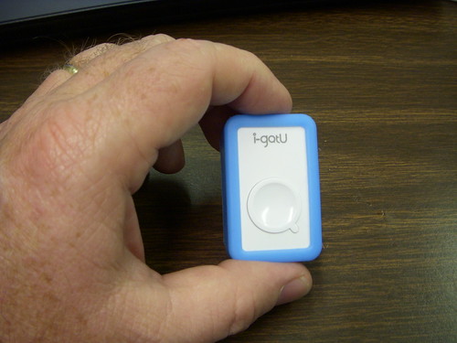
A little over a year ago I tried out the i-GotU GT-100 GPS tracker from Mobile Action. At the time I was looking for a simple tracker for photo geotagging, and the GT-100’a small size and price ($49 from Amazon) were very appealing. I put the unit through a series of tests, and found it to be completely useless for geotagging, and wrote up two reviews to that effect (Test Driving the i-GotU GPS Tracker, and i-GotU GPS Tracker – Summary Review.) Those two reviews generated lots of hits and comments for this website, both for and against the GT-100.

Subsequently, I was contacted recently by Mobile Action and asked if I would be willing to try out the new GT-120. The unit arrived Saturday and I’ve been putting it through the same tests that I did with the GT-100. So far, I’m impressed, and pleasantly surprised. This unit appears to work much, much better, and geotags images like a charm.

Read More “i-GotU Revisited” »

Boulevard of (Broken) Dreams

Posted on May 13, 2009 By Tom 2 Comments on Boulevard of (Broken) Dreams
Geocaching and Maps, History and Genealogy, Local

Downtown from Wade Hampton
Evening view of downtown Greenville from Wade Hampton Boulevard

I walk this empty street
On the Boulevard of broken dreams
When the city sleeps
And I’m the only one and I walk alone

Green Day – “Boulevard of Broken Dreams”

The joy you find here, you borrow,
You cannot keep it long, it seems.
But gigolo and gigolette
Still sing a song and dance along
The boulevard of broken dreams.

Nat King Cole – “Boulevard of Broken Dreams”

Two shadows in the moonlight
Dance silently along the boulevard
Of dreams
Tonight

Dada – “Boulevard of Dreams”

A boulevard isn’t just any old street. According to Wikipedia, it is a “wide, multi-lane arterial thoroughfare…often with an above-average quality of landscaping and scenery.” Naming a road a “boulevard” means that it should be something special, something to evoke poetry and song as noted above. Some cities are known by their more famous boulevards – the Champs-Élysées in Paris, the Sunset Boulevard, Santa Monica Boulevard, Wilshire Boulevard, and Hollywood Boulevard in Los Angeles, for example. Greenville has Wade Hampton Boulevard.

Read More “Boulevard of (Broken) Dreams” »

Adding Google Earth to PowerPoint

Posted on May 6, 2009 By Tom 4 Comments on Adding Google Earth to PowerPoint
EdTech, Geocaching and Maps, Internet

I occasionally check to see what leads people to this website – what search terms they are using to find me, or what sites link to this one. Lately I’ve gotten lots of hits from search engines with people trying to find out how to embed Google Earth into Powerpoint. I had posted something a … Read More “Adding Google Earth to PowerPoint” »

Tales of a “Terra”-rist

Posted on April 24, 2009 By Tom 4 Comments on Tales of a “Terra”-rist
Geocaching and Maps

Last night I ran into a buddy of mine that happens to be an ATF agent. He gave me some inside scoop on an incident that I saw on the news earlier this week, one that’s given geocachers even more bad press.

On Tuesday someone reported a pipe bomb at the dam in Ware Shoals. The pipe was wrapped in camouflage tape and had the words “Terra Tube” stenciled on the side. My friend was called, and was on the way to investigate when he was told that it was OK, that it was just a Geocache.

It’s been interesting to watch the reaction to all of this. I know the person who placed the cache, and on his website he’s been outspoken about placing geocaches in inappropriate containers and locations. I don’t know how this one slipped past him, but it’s placed him in the position of having to make some uncomfortable apologies.

Read More “Tales of a “Terra”-rist” »

Getting More from Your Auto GPS

Posted on April 17, 2009 By Tom 2 Comments on Getting More from Your Auto GPS
Gear, Geocaching and Maps

I figured it was time for a round-up.  I’ve been talking a lot about doing various things with a GPS, but haven’t gone into much detail.  Chances are that you got a GPS for your car because you feel like you’re directionally challenged, or you just the convenience of plugging in an address and getting directions.  That’s about the extent of what most people do, but there is so much more.

Thought it might be time to talk about automobile GPSs in general, and how they can really benefit a serious rambler like myself.  The one I use is a Garmin Nuvi 205, but most of what I’ll cover here should work with just about any unit.  If you’re into geocaching, you’ll already be familiar with most of these concepts.

Read More “Getting More from Your Auto GPS” »

Peachtree Rock Nature Preserve – Unfiltered

Posted on April 12, 2009 By Tom 3 Comments on Peachtree Rock Nature Preserve – Unfiltered
Geocaching and Maps, Local, Photography, Travel

Peachtree Rock

This Saturday our Lowcountry Unfiltered group gathered for its monthly outing. We rendezvoused just southwest of Columbia to explore the Peachtree Rock Nature Preserve, managed by the Nature Conservancy and the South Carolina Department of Natural Services. Dr. John Nelson, botanist at USC, director of the state’s Herbarium, and member of our group would serve as our guide for the day.

Lowcountry Unfiltered Gathers

In addition to John and myself, five others joined us.  We gathered at the entrance to the preserve at about 9:00, and got some preliminary information from John.  The area is one of the first set aside by the Nature Conservancy, and contains several unique habitat areas, including a long-leaf pine ecosystem.  The geology is also unusual. A hard layer of rock called ironstone covers softer layers of sandstone.  The sandstone has been eroding out from under the resistant upper layer, creating unique geological formations such as the namesake Peachtree Rock.

Read More “Peachtree Rock Nature Preserve – Unfiltered” »

South Carolina Nature Preserves

Posted on April 10, 2009 By Tom 4 Comments on South Carolina Nature Preserves
Geocaching and Maps, Local

Peachtree Rock: The Rock (photo by Matt Richardson) I committed a major faux pas. I stole harvested an excellent Google Earth resource, but I forgot where I got it.  I want to give credit to the proper people for this gem, but I can’t for the life of me remember where the file came from.  … Read More “South Carolina Nature Preserves” »

Western SC Tower Tour

Posted on April 5, 2009 By Tom 7 Comments on Western SC Tower Tour
Entertainment, Geocaching and Maps, Local, Photography, Rants, Travel

Westminster/Oakvale Tower

It seems like spring break got away from me without my being about to get out and visit the lookout towers like I wanted. This Friday was one of the best days, as far as weather was concerned, so I was able to visit some of the locations. My target would be those towers located in Northwestern South Carolina, along with any other interested tidbits I might discover along the way. It was a push, but I managed to visit eight tower locations in one day.

Read More “Western SC Tower Tour” »

South Carolina Heritage Corridor

Posted on March 29, 2009 By Tom 2 Comments on South Carolina Heritage Corridor
Geocaching and Maps, Local, Travel

While out driving the rural highways of South Carolina you may have come across a road sign with this symbol… Seeing a road sign like this lets you know that you are on either the South Carolina Discovery Route, or the South Carolina Nature Route, both parts of the South Carolina Heritage Corridor. On the … Read More “South Carolina Heritage Corridor” »

Posts pagination

Previous 1 … 9 10 11 … 21 Next

Categories

  • EdTech (197)
  • Entertainment (202)
  • Family (124)
  • Gear (114)
  • General Technology (98)
  • Geocaching and Maps (208)
  • History and Genealogy (276)
  • Internet (142)
  • Local (459)
  • Miscellaneous (561)
  • Music (202)
  • Paddling (268)
  • Photography (782)
  • Podcast (21)
  • Rambling (234)
  • Rants (162)
  • Recipes (37)
  • Religion (48)
  • Restaurants (165)
  • Science (48)
  • Things Overheard (29)
  • Travel (413)
  • Uncategorized (144)
  • Washington Sabbatical (113)
  • Weirdness (61)

Recent Posts

  • A Trip to Lando
  • Carolina Ghost Towns – Fort Motte, South Carolina
  • Carolina Ghost Towns Season 3 Trailer
  • Thanksgiving at Home
  • Home!

Recent Comments

  • Virginia Pepper on A Trip to Lando
  • julie niemeyer on Perryville Pickin’ and Grinnin’
  • Heath H Cowart on The Haunting of Farr’s Bridge
  • Sheryl Gunter Bingham on Chasing the Swamp Rabbit – Part 3, Sievern and Edisto Academy
  • Jerome A Mann on Update on Ghost Town Research

Tags

blogging cemetery Christmas Columbia Edisto River edtech Entertainment family Flickr Florida Furman Furman University gear Georgia geotagging Ghost Town Ghost Towns Google Earth Google Maps GPS Greenville Greenville Chorale history Instructional Technology kayaking Lake Jocassee LCU Lowcountry Unfiltered maps Music North Carolina Paddling Photography rambling restaurant Restaurants review singing social networking South Carolina time-lapse Travel video Washington Washington State
January 2026
S M T W T F S
 123
45678910
11121314151617
18192021222324
25262728293031
« Dec    

Copyright © 2026 Random Connections.

Theme: Oceanly by ScriptsTown