It seems like spring break got away from me without my being about to get out and visit the lookout towers like I wanted. This Friday was one of the best days, as far as weather was concerned, so I was able to visit some of the locations. My target would be those towers located in Northwestern South Carolina, along with any other interested tidbits I might discover along the way. It was a push, but I managed to visit eight tower locations in one day.
Glassy Mountain
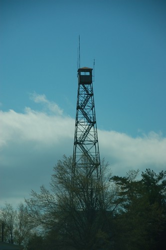
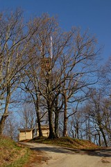
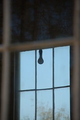
I started with an easy one – Glassy Mountain. I had visited it many times before, but that was prior to my starting this project. I had to make it official, so I drove over to Pickens and took the drive to the top of the mountain.
The tower is very accessible. You can get right to its base. However, a fence with barb wire does surround it, and the lowest flight of stairs has been removed, so you can no longer climb it. It looks like the cab is still intact, but is very rusty. I don’t know what condition the floor would be in. The tower seemed shorter than I remembered. I guess with such a commanding view, you really didn’t need much height.
As I walked around taking photos a woman pulled up in a pickup and got out. She said that she had just moved to the Easley area and had never been to the top of the mountain. We chatted a bit, and I told her about the trails around the top of the mountain out to some of the rock faces. She had places to go, and I had more towers to find, so we soon went our separate ways.
The route to my next target, Stringer Ridge, took me through downtown Easley. I decided to drop in on Poor Richard’s Bookstore, where local blogger Laura Llew works. Laura wasn’t in today, but the bookstore turns out to be a very cool place, with lots of local titles. I purchased a copy of the 40th Anniversary Edition of Foxfire, and continued my trek.
Stringer Ridge
As I drove south out of Easley it became very apparent as to why the lookout tower program was discontinued. The Powdersville area, like most of Greenville County, is now covered with housing developments. There’s hardly any forest left to watch over.
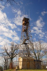
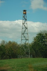
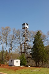
Eventually I got out from under the pall of housing sameness and into open farmland. South of the Old Greenville Highway (Highway 88) one finds another Firetower Road. This one leads to Stringer Ridge Tower. The tower can be seen in an open field for a quite a ways. As with Glassy, the bottom flight of stairs had been removed and there was a fence around the base. The cab was not in very good condition. Part of the floor was missing, so it didn’t look like the cab would be safe. The tower itself was quite tall.
I had confirmed that the tower was still standing from Street View. The image clearly showed the tower was still standing.
As I selected the next location in my GPS something became clear. I had read that these towers had been placed approximately 15 miles apart. Glassy, from which I had come, was about 14 miles to the north, and Issaqueena, my next stop, was about 16 miles to the northwest.
Unknown Tower
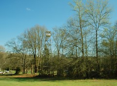
As I was following my GPS directions, I stumbled upon an unusual find – a tower that didn’t appear on any of my databases was sitting right there on the side of Highway 123. I took the next exit and followed the frontage road around to the tower location.
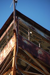
The tower appeared to be in excellent condition, in fact, too good. It also appeared to be out of place. The tower was too short for the location. There is no way that it would have a commanding view of the surrounding terrain. It’s more likely that someone purchased the tower, then moved it to this location.
Issaqueena Tower and Lake
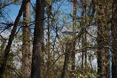
I continued on my journey toward Issaqueena Tower, north of Clemson. I could only get a glimpse of the tower through the woods, and couldn’t get close enough for a good shot.
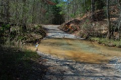
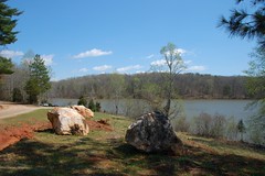
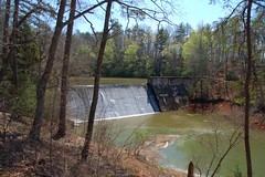
While I was there, I drove on around the dirt road into the Issaqueena Lake recreational area. The dirt road turned out to be a challenge, especially with the recent rain. At one point I had to ford a small stream. However, I did make it to an access area for the lake, and made my way around to the dam itself.
I drove on back to Clemson and had a quick lunch, then headed toward my next target, the Clemson Tower.
Old Stone Church and Clemson Tower
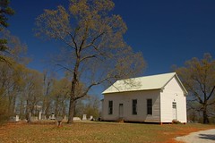
I was heading down Highway 76 when I glanced over to the right saw an old stone church and cemetery. A quick detour was in order. This place was actually known as The Old Stone Church. I pulled in and starting taking photos of the outside.
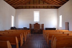
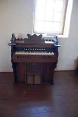
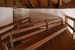
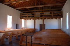
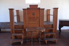
A caretaker was trimming the grass, and asked if I wanted to see the inside. Of course I answered in the affirmative. The interior was very simple, with a pulpit, pump organ, and rectangular grand piano. A separate exterior staircase led up the the slave gallery, and it was open, so I headed up there, as well.
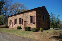
The church was organized in 1797 as the Hopewell-Keowee Presbyterian Church, and General Andrew Pickens is buried in the cemetery. In the 1960’s the church was taken apart stone by stone and rebuilt.
From the church I continued south. The Clemson Tower turned out to be a bust. I drove to the location, but there was no tower to be seen. Time for the next tower.
Westminster-Oakway Tower
The next tower was on the other side of the lake, so I drove on down to I-85 and headed back northward. I was tempted to stop in Townville to shoot some of the interesting buildings in the area, but the afternoon was getting away, so I continued on.
At the community of Oakway I came across a little white frame church and cemetery that looked intriguing. I couldn’t find any information on the church – not a sign, or anything. I peeked through the windows and saw another plain interior. The inside would be illuminated by six bare light bulbs hanging from the ceiling.
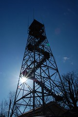
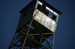
I’m not really sure of the name of this next tower. Waymarking.org has it listed as Westminster Tower, but it’s really in the community of Oakway. It wasn’t on any of the SC Forestry Commission databases. However, I found it with no problem. The tower appeared to be in good condition, but once again the bottom flight of stairs was missing.
Here I had a choice. I could either head south toward a couple of towers in Anderson County, or I could head north further into Oconee. I picked north.
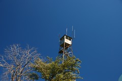
Yellow Branch, Round Mountain, and Long Mountain
Yellow Mountain turned out to be a bust. Located on Highway 28 right across from the Stumphouse Tunnel area, the location now has a modern house. The tower is no longer there.
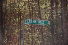
The next one on my list was called Long Creek, but it was located on Round Mountain. The Round Mountain Tower Road was blocked, and there was a 1.7 mile hike to the top of the mountain. If it had been earlier in the day I might have attempted it, but not today.
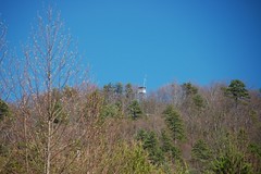
I did drive on around through the Long Creek Community, and was able to spot the tower from a distance, to at least verify that it was still standing.

From Long Creek I headed to Long Mountain. I turned onto yet another Fire Tower Road, which wound around a bit, then came to yet another blocked gate. I was momentarily taken aback when a pickup sporting twin rebel flags pulled in, blocking my exit. However, I think they were as startled to see me as I was them. They pulled off to the side, and I was able to leave, not having seen anything of the tower.

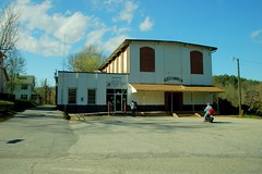
Newry Mill
I was pretty much done with towers for the day. I had one more stop to make, though. I drove over to the town of Newry, a little mill village located on the other side of the Lake Keowee Dam. It was an interesting place, but I didn’t feel comfortable sticking around to take too many pictures. Perhaps another day when I have more time.
Tom
If you ever expand your fire tower search into the Midlands there is a standing tower in Gaston, Lexington County within a small park just off US 321 on the west side of town. Don’t know if possible to climb this tower. Another tower stand in Eastover in southern Richland county. There was write up on this one on WIS TV web site back in 2001. According to the article (which ( have saved if you want a copy) it is privately own and known as the Eastover Eiffel Tower. Complete with AC/heat and other comforts of a den. Still have to walk up and down 138 steps. Unfortunately no photos.
Joe
Thanks, Joe. I’m going to be in the Columbia area tomorrow, and may try to swing by the Lexington location.
I lived at Cleveland Tower in Greenville county from age 7 to 18 and can give you information about the four locations in the county if you would like.
Thanks,
Mack Burgess
I’m a Clemson student doing a project on fire towers and this was very helpful to me, so thanks! I’ve visited the Long Mountain tower that you said was gated; it was a lucky day and I drove right up to the top, where a hole had been cut in the surrounding fence and the tower was open and (mostly) safe. Tomorrow I’m going to check out the Clemson tower–it does exist, but it’s only visible in the winter. I contacted someone about it and I’m hopeful about going up! I’m glad to know now not to waste time with Glassy Mountain and Easley if I can’t climb them, and I think I will try hiking the one at Round Mountain. Glad to know somebody else thinks fire towers are cool. 🙂
I have a picture of the Round Mt tower taken from my house in Toccoa, Ga.
Send me your email address and i will forward it to you.
Tom, where on 123 is the unnamed one?
Here’s a Google Map link – https://maps.app.goo.gl/axUHzrcjJKzQFfKu8