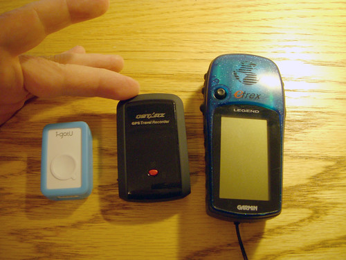
As I stated in my last post, the i-GotU GT-120 was a pleasant surprise. The unit functions much better than the GT-100 that I purchased and returned last year. It geotagged images accurately from my little Nikon S50 camera. However, in my last tests I ran into some puzzling problems – not with the GT-120 but with my QStarz BT-1000 and also with my big Nikon D50 DSLR. Where both had worked together accurately for quite awhile now, neither was able to get a geotagged image – the D50 with either GPS tracker, and the BT-1000 with either camera. More tests were needed. The problems appeared to be related to incorrect time-codes, so I started from that basis.
Before I got started with the comparison tests, I did another quick test of the GT-120. On Monday I kept it in my pocket all day. The unit was able to track my location the entire time. Another good sign for the GT-120.
For my first comparison test I set up my Nikon S50 in interval mode, shooting one shot every 30 seconds, and placed it on my dashboard for the drive home from work. I put the GT-120 and the BT-1000 on the dash beside the camera. When I got home I made two sets of the images and downloaded the GPS tracks from both units. The GT-120 geotagged the images with no problem. The BT-1000, however, placed all of the images at the very end of the track.
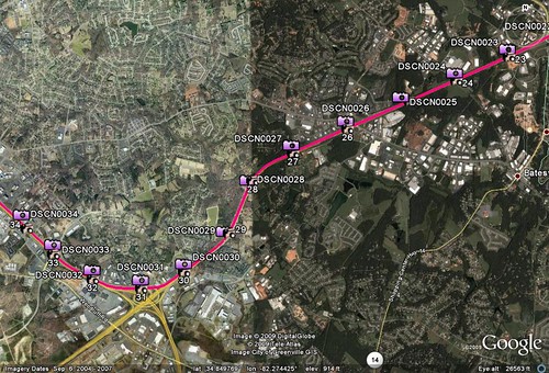
An examination of the GPS track showed me that the BT-1000 had never reset for Daylight Savings Time. Fortunately, the accompanying software has a time-shift utility. Once I shifted the photos back an hour, it located the images accurately. The image below shows both the GT-120 and the BT-1000 images as located in Google Earth.
Of course, this was still with my little point and shoot Nikon. All of this would be for naught if I couldn’t get it to work with my DSLR. For the second test I double-checked the time on the D50, and sure enough, IT had never been reset for Daylight Savings Time. That’s why the GT-120 couldn’t find any of its images on my earlier test run. The clock was not off by an exact hour, so a when I did a one-hour time shift in my previous test, it was able to geo-locate the image, but not accurately. I set the clock on the D50 to match the S50, and set off for one final test.
As with previous tests I placed the GT-120 and the BT-1000 side-by-side on my dash board and drove to work – the exact same route as the previous test. This time I took random photos out the window with my DSLR. I made sure that I took pictures of intersections and easily recognized landmarks, such as overpasses, so that I could gauge accuracy of both GPS trackers.
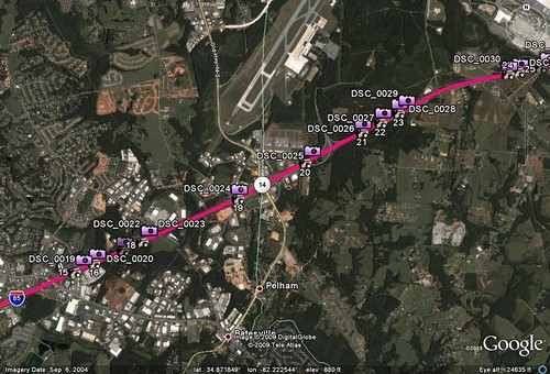
With the clock reset on the DSLR, the GT-120 was able to accurately geo-locate the photos without any problems. The BT-1000 was able to locate the images, but only after I had done a one-hour time shift for Daylight Savings Time. There were some discrepancies, though. The BT-1000 did tend to place the images closer to their actual location. The GT-120 had more images that were slightly off. I think this might be due to the update settings on both units. The BT-1000 was taking a location reading every 5 seconds, and the GT-120 was taking one every 6 seconds. That might be enough to throw things off if you want pinpoint accuracy at highway speeds, but not enough to cause problems while walking around with your camera. Fortunately, this setting can be changed on both units.
The image below shows the results of the Nikon D50 tracks from the GT-120 and BT-1000 in Google Earth…
After running all of the tests, I downloaded a new update for the BT-1000 software. The new version does include a check box for Daylight Savings Time. I’ll just have to remember to occasionally check the time on my camera, and to reset it with the time change.
So, which one of these GPS trackers will I use? Not sure for now. The i-GotU is certainly smaller and more convenient. Now that accuracy for both cameras is not an issue, I’ll probably alternate using both trackers. The software for each has similar capabilities, both can output a GPX file, both can output to Google Earth (although the BT-1000 creates smaller KMZ files), and both seem to have similar battery life. The main advantage of the BT-1000 is Bluetooth, and that’s not a feature I use. Right now, it’s a toss up, but I’m glad I’ve got options.
Hi Tom,
I’ve have recently purchased a GT-120 and after reading your thorough review I was wondering if you could clarify something for me.
I conducted a quick test of the GT-120 by driving round my local business park with a 3sec interval set on the unit. When I viewed this within Google Earth the track wasn’t particularly accurate (e.g. it ran through buildings, I started/stopped at the exact same parking space but this wasn’t reflected on the map).
I reset the unit to a 1sec interval, which improved the situation only slightly (the start/stop point again didn’t match, ran through buildings etc.).
Admittedly the day was overcast and raining but when you describe the fact that you managed to get a signal with the unit in your pocket, that shouldn’t be an issue – what am I missing e.g. do you leave the unit x minutes before starting off, tweak the waypoints afterwards etc.? Any advice would be much appreciated.
All the best, Rich