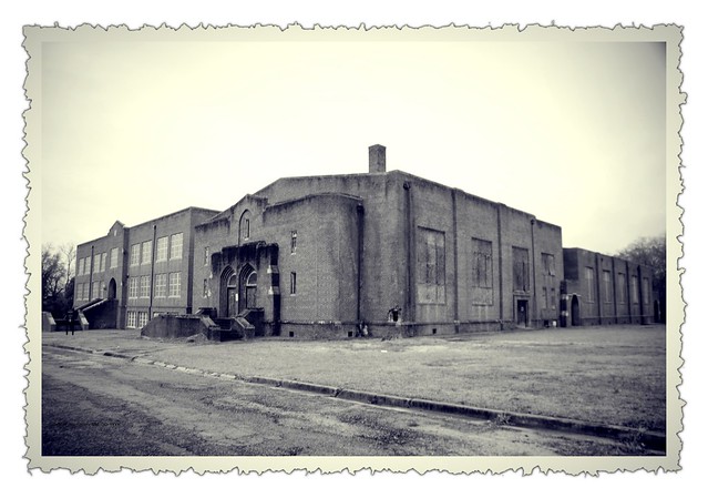
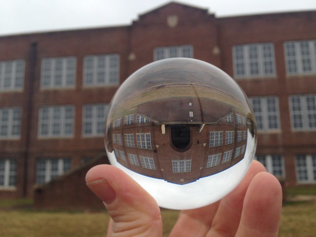
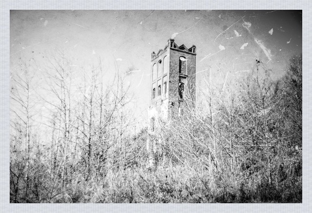
Skip to content

Random Connections

A collection of photography and exploration focusing on Upstate South Carolina and beyond.

  • Home
  • About Us
  • Photos
  • Resources
  • Other Voices
  • Post Archives
  • Podcast
  • Home
  • History and Genealogy
  • Page 12

Category: History and Genealogy

Journey to Mount Zion – Part 2

Posted on February 1, 2016February 1, 2016 By Tom 2 Comments on Journey to Mount Zion – Part 2
History and Genealogy, Photography, Rambling

Vintage B&W photo

Yesterday I had made a trek down to Winnsboro to donate a crate of Shivar Springs bottles to the Fairfield County Museum. I had a great visit and made some new friends. Sadly, I hadn’t been able to get inside the old Mount Zion Institute. My fellow photographers were not able to join us yesterday, so it was rescheduled for today. I decided that this is a one-shot chance, so I decided to make a second trip down to Fairfield County.

Read More “Journey to Mount Zion – Part 2” »

Journey to Mount Zion – Part 1

Posted on January 30, 2016 By Tom 4 Comments on Journey to Mount Zion – Part 1
History and Genealogy, Photography

Untitled

Mount Zion Institute – the old school is an imposing edifice just off of the main street of Winnsboro, South Carolina. I had visited the old school several times over the past few years, most recently a year ago on our 2015 MLK Weekend Ramble. Over the past two days I’ve been granted rare access to interior of the building and was able to photograph it extensively. I’ve also made some wonderful new friends in Winnsboro and at the Fairfield County Museum.

Read More “Journey to Mount Zion – Part 1” »

The Mills of the Pacolet River Basin – Part One, Glendale

Posted on December 10, 2015December 10, 2015 By Tom 14 Comments on The Mills of the Pacolet River Basin – Part One, Glendale
History and Genealogy, Local, Photography, Rambling
Glendale Mill Ruins
Glendale Mill Ruins

I have a confession.  When things get chaotic I have occasional bouts of depression.  One of the best ways to combat this is to get away from the house and start exploring.  Such was the case Tuesday of this past week.  I needed out of the house.  I wasn’t sure where I was headed, but preferably somewhere interesting where I could take some photos.  I headed east.  It was familiar territory, and places I had already visited and photographed, but even familiar ground can yield new discoveries. My explorations took me across Spartanburg County and to the mills along the Pacolet River Basin – Glendale, Clifton, and Pacolet itself, with a couple of outliers thrown in for good measure.

Read More “The Mills of the Pacolet River Basin – Part One, Glendale” »

Pathfinders and Map Makers – Part One

Posted on October 28, 2015October 28, 2015 By Tom 3 Comments on Pathfinders and Map Makers – Part One
Geocaching and Maps, History and Genealogy

Pathfinder with Trailer

It was early 20th Century and cars were just coming into their own. However, the roads weren’t keeping up. Most were still dirt tracks at the best of times, and terrible mud pits at others. A cross-country trek was an adventure, and only for those with the means to obtain and maintain an automobile. Greater buy-in was needed from the general public so that bond initiatives and legislation could be passed. Thus was born the age of the Pathfinders, adventurous souls who sought out the best routes, laid out the paths for early highway systems, and brought to the public awareness of the need for good roads.

Read More “Pathfinders and Map Makers – Part One” »

In Search of Good Roads for South Carolina

Posted on October 27, 2015October 27, 2015 By Tom No Comments on In Search of Good Roads for South Carolina
Geocaching and Maps, History and Genealogy

NC Good Roads, Johnson County, circa 1909

The recent flooding in the mid-state has pointed out some of the glaring problems with South Carolina’s infrastructure. Even before the floods, the issue of deteriorating roads has been foremost, with discussion about how to fund road repairs. This isn’t a new problem, though. The question about how to develop and maintain adequate infrastructure is not a “one and done” proposition. First there was the King’s Road and Great Wagon Road, then in the 1820s it was the development of the Santee Canal and the State Road. The development, maintenance, and funding of an adequate means of transportation was, and always will continue to be an issue.

In the last post I made a few comments about the roads around Greenville – basically trails that connected town to town. The condition of those roads was often appalling. This was true for the entire country around the turn of 20th century. The automobile was just taking off, but getting anywhere proved to be a challenge. Thus, the Good Roads Movement was born.

Read More “In Search of Good Roads for South Carolina” »

The Streets of Greenville

Posted on October 22, 2015April 26, 2023 By Tom 3 Comments on The Streets of Greenville
Geocaching and Maps, History and Genealogy, Local

Greenville Map 1948

My late father-in-law had a problem with Greenville. He grew up in the wilds of Idaho along the Salmon River. However, he spent most of his adult life in large western cities, namely Los Angeles, where the streets are laid out in neat, tidy grids. Greenville’s streets always left him bewildered.

Whenever he gave me trouble about my hometown, I would reply that it makes perfect sense – Laurens Road goes to Laurens, Augusta Road goes to Augusta, etc. While that’s true, there are lots of other…questionable routes, and I could see how someone not from here would be very confused. Greenville’s streets are based on an early 19th Century design, and that pattern STILL influences our traffic.

Read More “The Streets of Greenville” »

Spirit of 45 Military Vehicles on the Bankhead Highway

Posted on September 27, 2015 By Tom No Comments on Spirit of 45 Military Vehicles on the Bankhead Highway
Geocaching and Maps, History and Genealogy, Local, Photography

MVPA Convoy Desaturated

There’s a reason I named this blog RandomConnections. The URL RandomThoughts was taken…but that’s beside the point. Time and time again the idea of “random connections” has proved itself to be the more appropriate title, as tenuous threads appear that seem to bind disparate ideas together. Such was the case this past week.

I got a forwarded e-mail from my brother, Stephen, with a note that a historical convoy would be passing through our area. The convoy would feature vintage military vehicles, and I thought it would be a cool photo opportunity. Little did I realize how closely this event would tie right into my recent research and explorations.

Read More “Spirit of 45 Military Vehicles on the Bankhead Highway” »

The Journey Home from Olanta

Posted on September 26, 2015September 26, 2015 By Tom No Comments on The Journey Home from Olanta
Geocaching and Maps, History and Genealogy, Photography, Rambling

South Lynchburg Store Sepia

It had been a long day. I had gotten up early and driven down to Orangeburg, then followed the Tobacco Trail along US Highway 301 through Orangeburg and Clarendon Counties. I had crossed over into Florence County into the town of Olanta. I thought about pushing on to the town of Florence, but when I checked my GPS I saw that it was going to take several hours to get home as it was, so it was time to head back. Even so, I made a couple of stops and detours. These were interesting sights worthy of documentation, but I didn’t think they fit with the Tobacco Trail narrative.

Read More “The Journey Home from Olanta” »

Lunch on the Tobacco Trail at the Chat n Chew

Posted on September 25, 2015September 25, 2015 By Tom 1 Comment on Lunch on the Tobacco Trail at the Chat n Chew
Geocaching and Maps, History and Genealogy, Photography, Rambling, Restaurants

Chat-N-Chew Sepia

I do my homework before I go out on these extended photo expeditions. I like to know what’s in an area so that I make sure I can get to my intended target. Sure, I miss things. There were lots of things I had to skip on this particular trek. Sometimes I find too much, and those extra places of interest become distractions from my intended target. Sometimes, though, things work out perfectly, as was the case with lunch at the Chat n’ Chew in Turbeville on this particular trek.

Read More “Lunch on the Tobacco Trail at the Chat n Chew” »

The Tobacco Trail through Clarendon County

Posted on September 25, 2015 By Tom 4 Comments on The Tobacco Trail through Clarendon County
Geocaching and Maps, History and Genealogy, Photography, Rambling

Motel Featherbed

I had come to a roadblock on the Tobacco Trail, quite literally. The Highway 301 bridge across Lake Marion still exists, and still connects across the lake. However, in 1987 it was closed to automotive traffic, and now serves as a fishing bridge. If I were going to cross from Orangeburg into Clarendon County, I was going to have to do some backtracking.

Read More “The Tobacco Trail through Clarendon County” »

Posts pagination

Previous 1 … 11 12 13 … 28 Next

Categories

  • EdTech (197)
  • Entertainment (202)
  • Family (124)
  • Gear (114)
  • General Technology (98)
  • Geocaching and Maps (208)
  • History and Genealogy (275)
  • Internet (142)
  • Local (459)
  • Miscellaneous (561)
  • Music (202)
  • Paddling (268)
  • Photography (781)
  • Podcast (19)
  • Rambling (233)
  • Rants (162)
  • Recipes (37)
  • Religion (48)
  • Restaurants (165)
  • Science (48)
  • Things Overheard (29)
  • Travel (413)
  • Uncategorized (144)
  • Washington Sabbatical (113)
  • Weirdness (61)

Recent Posts

  • Thanksgiving at Home
  • Home!
  • Helene One Year Later
  • Once Again, Up the Long Nose
  • Upstate Renaissance Faire

Recent Comments

  • Marty McDaniel Brownlow on Getting Pulled into Union County – Part 2, Union to Mount Vernon
  • James D. Bell on Exploring Jacks Township
  • Tripp Clement on Thanksgiving at Home
  • James Lewis on Remembering the Walke
  • James Lewis on Remembering the Walke

Tags

blogging cemetery Christmas Columbia Edisto River edtech Entertainment family Flickr Florida Furman Furman University gear Georgia geotagging Ghost Town Ghost Towns Google Earth Google Maps GPS Greenville Greenville Chorale history Instructional Technology kayaking Lake Jocassee LCU Lowcountry Unfiltered maps Music North Carolina Paddling Photography rambling restaurant Restaurants review singing social networking South Carolina time-lapse Travel video Washington Washington State
December 2025
S M T W T F S
 123456
78910111213
14151617181920
21222324252627
28293031  
« Nov    

Copyright © 2025 Random Connections.

Theme: Oceanly by ScriptsTown