It’s funny how things work out sometimes. I was putting together that last post and stumbled upon a whole world of new possibilities for embedding content into Google Earth. I noticed that several of the embed codes used the <iframe> code and just referenced a URL for the embeddable media. I began to wonder if it would work with any URL, and sure enough, it does!
One of the biggest drawbacks of Google Earth is that it doesn’t have a WYSYWIG HTML editor for placemarks. If you want to include HTML content, then you have to know how to code. That can be a pain for teachers, who are, in general, afraid of coding. Using embeddable content was one way around this. Using <iframe> takes this one step further and makes just about ANY website embeddable.
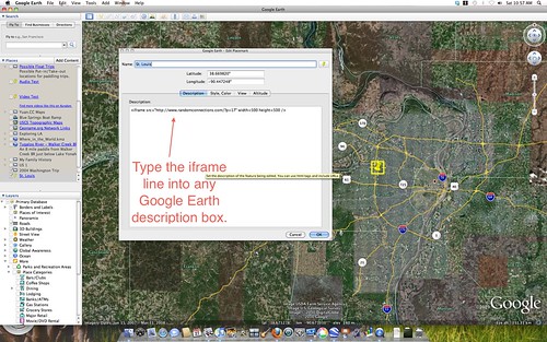
Here’s how it works. Just put the following line in any description box in Google Earth, be it placemark, overlay, folder, etc…
<iframe src=”http://www.someURL.com” />
Make sure to replace “www.someURL.com” with your website. The website will appear in the placemark’s balloon when you click on it. Depending on your Internet connection speed, it may take a moment or two for it to load.
You’ll probably notice that the balloon is rather small for the website, and that you have to scroll right and left to see anything. That’s not good, so I suggest increasing the size of the page as follows:
<iframe src=”http://www.someURL.com” width=500 height=500 />
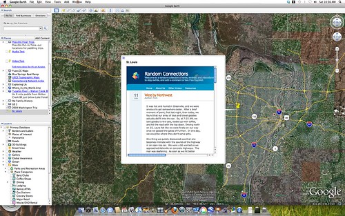
This gives you a bit more screen real estate. You don’t want to get too large with the bubble because it will cover too much of your Google Earth map. Unfortunately, scrolling will have to be a part of this, but at least you can make it large enough so that it can be read without too much trouble. Below is an example using a 500X500 and embedding a link to one of the posts from this website…
There are other properties you can use with <iframe> in Google Earth. This table lists them, along with the proper syntax. Keep in mind that their examples assume that you are embedding the frame in another website, rather than in Google Earth.
I’ve found that Flash components tend to crash when embedded into an <iframe> in Google Earth. If the website you want to use has video or audio, it’s probably not going to work. In fact, the simpler the website and the less formatting, the better. If you’re design savvy, you could structure some CSS to detect a smaller screen and format the content appropriately.
So, how might you use this? Here are a couple of ideas…
1. Location-Related News
Create a Google Earth file that embeds news articles for specific locations for a “What’s Happening Around the World” activity.
2. Travel Blogging
Set up a travel blog on Blogger.com or similar service. Have the <iframe> reference the URL for specific blog posts rather than the entire blog.
I would have love to have know about this when we did our trek across country in 2004, or had taken our London trip in 2006. I may try it for our next excursion.
by chance have you found it to be possible to embed the Google Earth itself (initial Globe view) into a web page so that visitors can swoop down from space into your area of focus?
Jimbo – About the only way to do that used to be with the Google Earth plugin. However, Google Maps has just released it’s “Earth” view, which can be embedded. I haven’t played with it, but what you describe seems possible with this new release.