Skip to content

Random Connections

A collection of photography and exploration focusing on Upstate South Carolina and beyond.

  • Home
  • About Us
  • Photos
  • Resources
  • Other Voices
  • Post Archives
  • Podcast
  • Home
  • Geocaching and Maps
  • Page 7

Category: Geocaching and Maps

0

Where were you born?

Posted on July 11, 2011 By Tom No Comments on Where were you born?
EdTech, Geocaching and Maps, Internet

Dear Twitterites, Facebook Friends, Google Plussers, and RandomConnections Readers: I need your help with a project.  This summer I’m doing several workshops for SCETV on Google products, including Google Earth and Google Docs. I’m hoping to include some information on Google Fusion Tables as part of the workshop, and in order to do that I … Read More “Where were you born?” »

More Obsessions and New Tools

Posted on June 20, 2011 By Tom No Comments on More Obsessions and New Tools
Geocaching and Maps, History and Genealogy

Chick Springs Springhouse and Gazebo

Photo by Flickr photographer markemark4

I have yet another location-based obsession, possibly even several more. First it was fire towers, then old schools, and lately it’s been ghost towns. You would think I’d have enough abandoned historic stuff to go traipsing about the countryside to photograph and document. But wait! There’s still more!

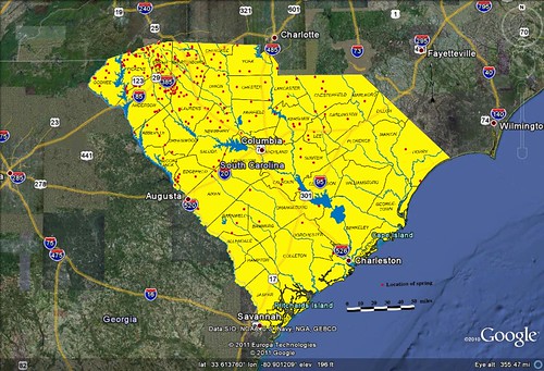
While visiting Laurens County recently we stopped by Stomp Springs, and this past weekend we found the Shivar Springs bottling cisterns near Shelton in Fairfield County. That got me thinking about mineral springs, and where these might be located.

A 2004 Department of Natural Resources report by H. Lee Mitchell (PDF) gives some of the background of the springs and their locations. The report mentions the historical significance of springs, as well as the development of resorts and bottling facilities. These dot the state, but most are located inland of the Fall Line, as indicated by the map in the report (which I’ve imported into Google Earth as an overlay.)

Mineral Springs GE

Read More “More Obsessions and New Tools” »

Revisiting Eastern Fairfield County

Posted on June 18, 2011 By Tom 3 Comments on Revisiting Eastern Fairfield County
Geocaching and Maps, History and Genealogy, Photography

Blair General Merchandise

A couple of weeks ago Glynda and I had been down to see the parents, and had stopped back by Renno and Stomp Springs. On Friday we had made another trip to Prosperity, and decided we would catch a couple more locations on the way back this time. We passed through some truly remote areas and visited a few towns that could just about qualify as ghost towns.

Back in January we had taken the parents on a right through the southwestern corner of Fairfield County, and along the eastern shore of Lake Monticello. This time we extended that earlier trip, with stops in Jenkinsville and points further north on Highway 215.

Shiloh Methodist

Read More “Revisiting Eastern Fairfield County” »

Geocaching on Lake Marion

Posted on June 13, 2011 By Tom No Comments on Geocaching on Lake Marion
Geocaching and Maps, Paddling, Photography

Lake Marion Paddling

Another second Saturday, and it was time for another epic paddling trip with Lowcountry Unfiltered. This one was truly epic. This time our explorations took us to the eastern part of Lake Marion to do some geocaching around Persanti Island.

Our launching point was Carolina King Landing, just north of the Santee National Wildlife Refuge. It’s a private landing with cabins for rent, and was quite the happening place when I arrived. It turns out that this was the day for the Sparkleberry Poker Run up at the north end of the lake. Lots of camouflaged boats were getting ready for departure.

Lake Marion Geocaching-2Lake Marion Geocaching-1Lake Marion Geocaching-4

Alan arrived, and we entertained ourselves with Cokes, Moon Pies, and conversation with the proprietors of the local shop. These turned out to be very nice folks, and were very helpful suggesting parking and launch spots for the boats. They also had some interesting taxidermy.

Read More “Geocaching on Lake Marion” »

GNIS Dilemma

Posted on June 6, 2011 By Tom No Comments on GNIS Dilemma
Geocaching and Maps, Internet

The Geographic Names Information System(GNIS) is one of the greatest boons to those of us who love maps. It’s an extensive database of place names created by the US Geological Survey, and includes cities, towns, communities, crossroads, schools, churches, mountains, rivers, etc,. etc. Basically, any place in the US that has a name is in the database. The database includes coordinates, county, and other basic information about that location.

I’ve used and referenced the GNIS data on this blog many times. The raw data is freely available for download, and I have downloaded just the South Carolina data to create my South Carolina Place Names application. If you’ve ever used a GPS or looked up a location on an online mapping system, you’ve encountered GNIS data. Unfortunately, some companies use this freely available data to flood the web with crappy websites that pollute search results and interfere with the ability to do any meaningful online research about an area.

Here an example…

Yesterday my sister Glynda and I drove through the communities of Stomp Springs and Renno on our way back from visiting our parents in Prosperity. It’s a historical area, and we snapped a few photos and looked at the ruins of the old towns. When I got home I wanted to find more information about the area, so I did a quick Google search for Renno, SC. Here’s the first page of results. You’ll want to click to enlarge…

Renno1.png by RndConnections on Aviary

Most of the pages are for “hometown locators” and various real estate companies. There were even multiple websites for various cable companies. This goes on for multiple search pages – basically a spamming of the Internet based on the GNIS data.

Read More “GNIS Dilemma” »

More on Elevation Profiles

Posted on April 27, 2011 By Tom No Comments on More on Elevation Profiles
EdTech, Geocaching and Maps

A couple of posts back I wrote about discovering Elevation Profiles for Paths in Google Earth. I’ve spent a little bit more time working with this, and came up with another neat activity for a classroom.

In the last post I created a path with only two endpoints – basically a straight-line cross section. I also did this across fairly large areas of land, entire states, in fact. This activity focuses in on the details a bit, and uses the directions section of Google Earth.

First, go to the Directions tab and input two locations. These can be addresses, lat-long coordinates, or any other type of locator. For this activity, I suggest keeping the distances fairly short, probably within about 50 miles. Here are some suggestions:

  • From your home to your school, workplace, or church
  • Between two cities
  • Between your house and your best friend’s house

In the example below, I used Greenville and Spartanburg.

Screen shot 2011-04-27 at 6.17.33 AM

When you hit Enter or click on the magnifying glass search icon, you get driving directions between the two cities. For some strange reason Google Earth chose Wade Hampton Boulevard instead of I-85. I guess it went with the shortest route rather than the quickest. No matter – I can still illustrate the point.

Read More “More on Elevation Profiles” »

Elevation Profiles in Google Earth

Posted on April 18, 2011 By Tom 4 Comments on Elevation Profiles in Google Earth
EdTech, Geocaching and Maps

File this one under “How the heck did I let this one slip past me?” I’ve just discovered Elevation Profiles for Paths in Google Earth. I have no idea when this became a part of Google Earth (years ago?) but I came across this feature as I was plotting my river routes for my Backyard to Ocean post.

For any given path in Google Earth, you can select Elevation Profile and it will display a graph showing the rise and fall of that path from sea level. This works for ANY path, regardless of length or the number of anchor points. For demonstration sake, though, I like to use a path with only two anchor points – a beginning and and end.

Let’s say, for example, that you create a straight line path across the continental United States. You have two anchor points – one on the west coast, and one on the east coast. Your path would look something like this…

US Selection

Once you have saved that path to My Places, you can right click on the path and select Show Elevation Profile from the menu. That would give you a graph like this…

United States

Read More “Elevation Profiles in Google Earth” »

From Backyard to Ocean

Posted on April 16, 2011 By Tom 11 Comments on From Backyard to Ocean
Geocaching and Maps, Paddling

Backyard2Ocean

Last night Laura and I were sitting out on our deck look out over the backyard and down to the lake. I wondered what would happen if I were to put my kayak in the water here and paddle it all the way to the ocean. What would I encounter? What rivers would I paddle?

Actually, I’ve got a pretty darn good idea. I’ve paddled and/or explored some sizeable chunks of that route, so I know a bit about it. My paddle route would take this path…

Lake Fairfield –> Brushy Creek –> Enoree River –> Broad River –> Congaree River –> Santee River –> Atlantic Ocean

I’d love to be able to do that whole route without ever having to leave the boat. Unfortunately, there are a few things like shoals, trees, strainers, and a few dams in the way, not to mention Parr Shoals Reservoir and Lake Marion.

Read More “From Backyard to Ocean” »

Geotagging “Threat”

Posted on March 4, 2011 By Tom No Comments on Geotagging “Threat”
Geocaching and Maps, Internet, Photography

Just when you thought it might be safe to let the kids out of the house, the news media comes up with even more scary stuff that you didn’t know about. This time geotagged photographs are the culprit. Two separate news outlets – MSNBC and ABC, have aired segments on the dangers of posting geotagged … Read More “Geotagging “Threat”” »

Flickr to Panoramio – One More Attempt

Posted on February 18, 2011 By Tom No Comments on Flickr to Panoramio – One More Attempt
Geocaching and Maps, Photography

I really want to contribute to Panoramio.  Really, I do.  I would love to have my photos show up in a native layer on Google Earth without having to use a third-party KML/KMZ file.  So I’ve been looking for work-arounds for their security problems and inability to upload more than 10 images at a time. … Read More “Flickr to Panoramio – One More Attempt” »

Posts pagination

Previous 1 … 6 7 8 … 21 Next

Categories

  • EdTech (197)
  • Entertainment (201)
  • Family (123)
  • Gear (114)
  • General Technology (98)
  • Geocaching and Maps (208)
  • History and Genealogy (275)
  • Internet (142)
  • Local (458)
  • Miscellaneous (559)
  • Music (202)
  • Paddling (267)
  • Photography (781)
  • Podcast (19)
  • Rambling (233)
  • Rants (162)
  • Recipes (37)
  • Religion (48)
  • Restaurants (165)
  • Science (48)
  • Things Overheard (29)
  • Travel (413)
  • Uncategorized (143)
  • Washington Sabbatical (113)
  • Weirdness (60)

Recent Posts

  • Exploring Lake Summit
  • The End of Days
  • Double-Dipping on the Edisto
  • Jerk Chicken a la Farehouse
  • How’s the House, Part 3

Recent Comments

  • Kathleen on A Stonecutter’s Tale
  • Karl Plenge on Exploring Lake Summit
  • Virginia Pepper on Exploring Lake Summit
  • John Guerrant on Carolina Ghost Towns – Merrittsville
  • Laura A Davenport on Brandon Mill Cemetery Clean-up

Tags

blogging cemetery Christmas Columbia Edisto River edtech Entertainment family Flickr Florida Furman Furman University gear Georgia geotagging Ghost Town Ghost Towns Google Earth Google Maps GPS Greenville Greenville Chorale history Instructional Technology kayaking Lake Jocassee LCU Lowcountry Unfiltered maps Music North Carolina Paddling Photography rambling restaurant Restaurants review singing social networking South Carolina time-lapse Travel video Washington Washington State
September 2025
S M T W T F S
 123456
78910111213
14151617181920
21222324252627
282930  
« Aug    

Copyright © 2025 Random Connections.

Theme: Oceanly by ScriptsTown