Last night Laura and I were sitting out on our deck look out over the backyard and down to the lake. I wondered what would happen if I were to put my kayak in the water here and paddle it all the way to the ocean. What would I encounter? What rivers would I paddle?
Actually, I’ve got a pretty darn good idea. I’ve paddled and/or explored some sizeable chunks of that route, so I know a bit about it. My paddle route would take this path…
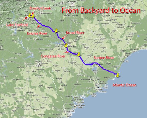
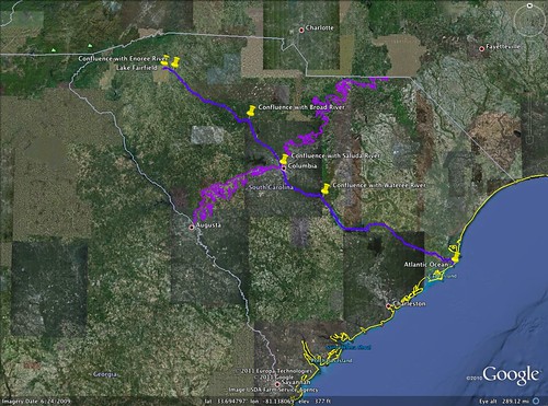
Lake Fairfield –> Brushy Creek –> Enoree River –> Broad River –> Congaree River –> Santee River –> Atlantic Ocean
I’d love to be able to do that whole route without ever having to leave the boat. Unfortunately, there are a few things like shoals, trees, strainers, and a few dams in the way, not to mention Parr Shoals Reservoir and Lake Marion.
Brushy Creek – 8.70 Miles
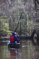
Brushy Creek heads up in the hills just below Piney Mountain. It flows past a chicken processing plant and through a few neighborhoods before combining with McCarter Creek to form Lake Fairfield. The creek is only navigable by kayak a few yards beyond our house, so our backyard would really be the starting point.

Once past the dam for our lake, the creek is no longer navigable. It flows generally eastward past just about every neighborhood of note on Greenville’s Eastside. As with our neighborhood, overbuilding in the flood plain increased problems with flooding, and houses are being removed all along the creek by the county. The school where I taught for many years, Brushy Creek Elementary School, takes its name from the creek.
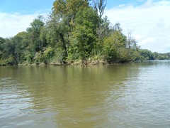
The creek takes on a more cultivated feel as it flows through the high priced Thornblade Country Club, then takes a quick trip back to its wilder roots as it turns southward through an industrial area. It passes under I-85, then ends its stretch at its confluence with the Enoree River at the water treatment plant in Pelham.
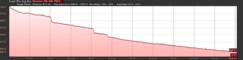
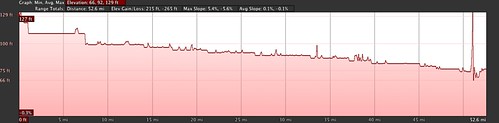
As seen in the Elevation Profile below, Brushy Creek drops about 145 over the course of the 8.70 mile section, or about 16 feet per mile. The peaks on the graph are a bit misleading – water doesn’t defy gravity and mysteriously flow uphill. Those are either anomalies in Google Earth, or they are where my mouse strayed over a higher bank when drawing the river route.
Enoree River – 85.1 Miles
This is the river I first started paddling in my teens, and the one I know most intimately. I’ve done a fair amount of the river, mostly through Laurens and Newberry Counties.
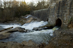
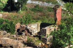
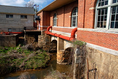
Just past its confluence with Brushy Creek the Enoree flows through the old Pelham Mill Dam. The river once provided power for the first textile mill in Greenville County at this location. All that remains are ruins, but the county has turned the area into a park.
Still narrow and rocky, the river sneaks past a few more neighborhoods and past some of the remaining farmland in the county. On the west bank is the Enoree Landfill, which I’m sure adds a lovely bouquet to the route, as well as its own special spices to the river.
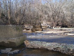
Here the Enoree serves as the boundary between Greenville and Spartanburg Counties. It flows past largely rural areas. At the community of Crescent the the current slows down at the site of an old dam, then takes a sudden plunge down Van Patton Shoals.
At Van Patton Shoals our family (along with many others) used to come wading at the river and have picnics. I’ve launched at least one float trip from this location, and I’ve even rappalled off of the bridge into the river. Good times.
There are a few more bumps and shoals, but then slows back down to its rural nature until it reaches its namesake town of Enoree. Another textile mill and another dam for power interrupt the free flow of the water. Just below the dam is the start of another one of my high school paddling trips.
The Enoree continues its slow rural flow downstream for many miles along the border of Laurens and Spartanburg Counties. It’s accented with a few shoals, usually also the location of historic mills. These include the shoals at Yarborough Mill and Horseshoe Falls at Musgrove Mill. Musgrove Mill is also the site of a Revolutionary War battle, and is now a park.
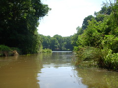
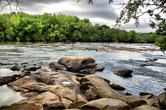
Here the river enters a more secluded stretch that includes long passages through the Sumter National Forest. The name “Enoree” means “river of muscadines” and it is here that the reason for the name becomes apparent. The character of the river doesn’t change much through this section – most of the shoals are upstream. However, tree limbs and the eponymous vines can cause tangles and strainers on the river.
The river continues like this past the town of Whitmire and through more of Sumter National Forest. Finally it reaches its confluence with the Broad River.

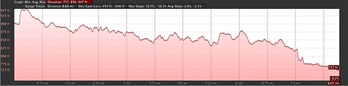
The Enoree doesn’t drop as steeply as Brushy Creek. However, it still loses about 6 feet per mile over its course, for a total drop of about 491 feet in elevation. The Elevation Profile shows a couple of significant drops over dams and shoals, but mostly a steady decline over the 83 mile course.
Broad River – 39 Miles
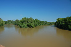
The Broad River already lives up to its name by the time the Enoree flows into it. At this point the river’s current and water levels are influenced by power production at Parr Shoals and how much water is being released over the dam. The only time I’ve paddled it, it was lake-like, and with a strong headwind the current didn’t count for much at all.
A main north-south railroad parallels the river, and communities such as Blair, Alston, Peak, and Shelton line the banks. About five miles downstream from the Enoree confluence and the community of Blair, one hits the headwaters of Parr Shoals. The V. C. Summers Nuclear Power Plant is located on Parr Shoals’ sister lake, Monticello Reservoir.
On the other side of the dam the river splits around Hampton Island, but rejoins at the community of Peak. An old railroad trestle that once connected Alston Station with Peak has been converted into part of the Palmetto Trail, and one can cross the river on foot on the old bridge.

From this point the river flows on down unobstructed toward Columbia. For a huge stretch there is no public access until you reach Harbison State Forest just above the state capital. A few miles above that the river hits the Fall Line, right at its confluence with the Saluda River. Together they form the Congaree River.
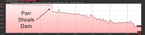
The elevation profile for the Broad River shows a significant drop. The Parr Shoals Dam can be seen on this graph as a vertical drop. Over all, though it loses only 136 feet in elevation over the entire course of the river.
Congaree River – 52.9 Miles
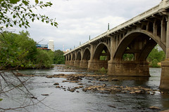
The city of Columbia was planned and laid out along the banks of the Congaree by a guy named Thomas Taylor. It’s located smack in the geographical center of the state, and right on the Fall Line. There is probably no clearer illustration of the Fall Line than right here. Upstream on the Saluda and Broad Rivers are significant shoals and drops. Water transportation was tricky, but those drops could be used to power mills. Downstream of the Fall Line the rivers enter the broad coastal plain, where they slow and broaden out. There is a historical economic distinction between the Piedmont and Upstate, and the Lowcountry, and it’s all (well, partly) due to the Fall Line. The Fall Line is shown in purple on this map…
As with most cities, Columbia treated the Congaree as an annoyance – something to bridge or ford – or as a convenient water source/dumping ground for industry. At one time the state prison was on the waterfront. The city has recognized the aesthetic value of this resource and built parks and greenways along both banks. There is the historical water works, Three Rivers Park, and several developed landings for kayaking and boating.
Once past the city public access to river extremely limited, all the way down to the Highway 601 bridge. The river drops through the midlands sand hills, then meanders in large loops past the cypress, tupelo, and loblolly forests of the Congaree Swamp.
Just below the Highway 601 bridge, the river joins the Wateree to form the Santee River.
The Elevation Profile for the Congaree clearly shows drops along the fall line, but then evens out. There is one spike toward the end where apparently I got lazy and let my mouse wander over one of the high bluffs along the banks as I was drawing the route. The river only drops 50 feet over its entire 52 mile run with less than 1 foot per mile in elevation change. Most of that occurs right at the Fall Line.
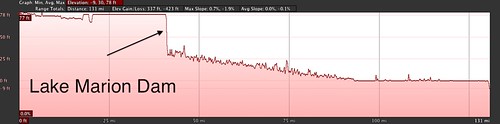
Santee River – 132 Miles
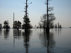
The Santee starts out and almost at once is subsumed by the backwaters of Lake Marion and the great Rimini/Sparkleberry Swamp. It does manage to maintain its identity as a river for about 10 miles past the confluence into the open water of the lake. However, channels open out right and left into the swamp. The area is wild and achingly beautiful.
Lake Marion itself is a wide body of water with one of the longest dams in the state. It’s a favorite for fishermen, and the town of Santee caters to tourism on the lake.
The Santee drops over the Santee Dam and here things get a little confusing. Canals have been built leading from Lake Marion to Lake Moultrie below, then leading out of Moultrie back to the Santee River. The river itself winds and loops through lowland forests. It follows this route across the coastal plain for the next 45 miles until it reaches its delta, splitting into a northern and lower branch.
Along the delta the river comes under tidal influences. Lowland forests give way to rice plantations and spartina marsh grass. The two main branches of the river delta finally reach the Atlantic Ocean between the towns of McClellanville and Georgetown.
The Elevation Profile shows the greatest change right at the Lake Marion Dam. The last 40 miles or so are relatively flat, and it’s this part that comes under tidal influences. Despite the large drop on the graph, the river only loses 86 feet over its 132 mile course, for an average loss of about 0.65 feet per mile. Most of that actually takes right at the dam.
So, could it be done? Could I paddle from my backyard all the way to the Atlantic Ocean? I think I could portage the dams, but the upper reaches of Brushy Creek and Enoree River are nearly impassible. It would be a long, wet hike while dragging a boat.
Despite the fact that I’ve paddled lots of these rivers I’ve never take a long expedition like this, and I’m not sure how I personally would hold up. However, I do have some experience with a trip like this. In 2007 I served as a consultant on a project by SCETV where nature photograph Richard Bernabe paddled from the North Carolina/South Carolina line on the Broad River all the way down to Charleston. His trip is documented on the RiverVenture website and includes video segments showing the sites along the way. My friend, SCETV producer Patrick Hayes, asked me to help with the blogging and mapping segments of the project.
Author and Wofford English professor John Lane actually did a Backyard to Ocean Paddle a couple of years ago. He lives on Lawson’s Fork Creek in Spartanburg, which has a much clearer path to the Pacolet River, then to the Broad River, than my route along Brushy Creek. Instead of following the canals to Charleston as Richard Bernabe did, he followed the actual river route down the Santee to the Ocean.
It can be done, but it would certainly be a trial as well as an adventure – 317.7 miles and an overall drop of about 900 feet. Below is an interactive map of the route, and you can download a Google Earth file here.
Interesting. If it were me, I’d consider bearing right across lake Multrie and ending up in a bar in Charleston to ease the aches and pains of a long journey. 🙂
My daughter and I are planning the trip from the Alston Bridge to charleston.will be late may before we can leave
How did that trip from Alston to Charleston go? I have not paddled the Broad River above Columbia before. I have done Columbia to Charleston before though.
Thanks, this is helpful! Some friends and I were looking to make a trip like this.
Great write-up. I was researching the trip from Charleston to Columbia and back with a bigger boat in mind. Stumbled upon this route. When I was at school at Clemson, I pondered paddling from Clemson to Savannah, but it never happened. Hope you have more will power than we did!
Tom.
How are you doing? Hope well. I got 2 Questions for ya. First do I read this as you live on Lake Fairfield? That is where I was raised. First My folks owned a split level on the upper end of the lake, the section of Lake Fairfield dr. that they removed. We always called it the swamp. Then up on the upper end of Hermitage on top of the hill. Then around the lake again to Linwood Ave. As a Kid I fish and ran the creek, lake and woods all summer long for years.
Lol. Now the important question. Below Van Patton Shoals on the Enoree River. 100 yards or so. I have seen what I thought were the remains of a dam. Was there a dam, maybe power station there?
Thanks
Tripp
Tripp, we do live on Lake Fairfield. It seems like most of the lake is swamp now. We used to be able to launch kayaks from behind our house, but we can’t now. Sometimes I wish there was a way to restore the lake, but we still enjoy the wetlands and wildlife.
There was a dam at Van Pattons, but it was upstream from the shoals, not downstream, as far as I know. I couldn’t find any historical topo maps of the area, but a 1921 soil survey map of Spartanburg County shows the water backing up around an island just upstream from the shoals.
The usual practice on Upstate rivers was to place the dam above any waterfall or shoals. This way they could take advantage of the height difference in order to drive turbines, etc.
I can’t remember the year. I’m thinking the early – mid 70’s they did some dredging on the lake and the creeks. Dumped the dirt in the area at the bottom of Selwyn Dr (Dead Man’s Hill). Back in the day those houses along Hermitage were lake front. I had a friend living in one of the houses. I think that house is gone now. Wow that lake has changed!
OK, I was able to find a 1935 Topo map on the Historical Map Viewer. It shows a power plant at that location, but doesn’t really indicate where the dam might have been.
That’s interesting. So maybe there was a dam and power house below the shoals, Maybe it broke and they rebuild above the shoals? Or just like you say, a better location for the fall height, rebuilt and removed the other dam. I would like to go back and see what is still there and get pictures. I want to say there was a round tower, not very tall and some places in the rocks, I assume where for securing something.
Tom so when are we going to paddle this whole thing all at once?