Skip to content

Random Connections

A collection of photography and exploration focusing on Upstate South Carolina and beyond.

  • Home
  • About Us
  • Photos
  • Resources
  • Other Voices
  • Post Archives
  • Podcast
  • Home
  • Geocaching and Maps
  • Page 13

Category: Geocaching and Maps

0

Creating Media-Rich Lessons with Google Earth

Posted on May 20, 2008 By Tom 3 Comments on Creating Media-Rich Lessons with Google Earth
EdTech, Geocaching and Maps

Sometimes it just clicks. As many workshops as I have done on Google Earth, I hadn’t really, truly understood its implications for the classroom. In most of my workshops, I had been focusing on the mechanics – basically how to navigate and create interactive placemarks. Now I’m going to emphasize using Google Earth as a … Read More “Creating Media-Rich Lessons with Google Earth” »

Seero – Geospatially Aware Video

Posted on May 12, 2008 By Tom No Comments on Seero – Geospatially Aware Video
Geocaching and Maps

In my discussions about geotagging, one of the questions that always arises is the issue what location should be tagged. If you’re tagging photographs, should you tag the location where you took the shot, or should you tag the location of the subject. For example, if you were standing on an overlook on the Blue … Read More “Seero – Geospatially Aware Video” »

Hey! What’s That?

Posted on April 29, 2008 By Tom No Comments on Hey! What’s That?
Geocaching and Maps

Via the blog Free Geography Tools, I’ve learned about one of the coolest new applications to take advantage of the Google Maps/Earth interface. The service is called “Hey! What’s That?” and it allows users to create panoramas from any point on Earth. Think of it this way… You’re up on the Blue Ridge Parkway and … Read More “Hey! What’s That?” »

Super Geotagged

Posted on April 28, 2008 By Tom No Comments on Super Geotagged
Geocaching and Maps, Photography

One of the problems with native KML support in Flickr is that it only displays the last 20 geotagged images from the specified search criteria. If you want a more inclusive display of Flickr geotagged images, you need to use something like Metaltoad, Flyr or Loc.alize.us. Flyr gives you better granularity of control for searches … Read More “Super Geotagged” »

SCETV Day 2

Posted on April 23, 2008 By Tom No Comments on SCETV Day 2
EdTech, Geocaching and Maps

Today’s workshops went very well. As with yesterday, I did a basic Google Earth workshop then an advanced session. Both sessions were well-received, and I got some good positive feedback. By sheer happenstance these workshops are following a logical progression. The basic session focuses on just getting used to the program. First, there is simple … Read More “SCETV Day 2” »

(Google) Earth Day

Posted on April 22, 2008 By Tom No Comments on (Google) Earth Day
EdTech, Geocaching and Maps

Since this is Earth Day, it seems only fitting that I spent the day doing workshops for SCETV on Google Earth. I did one basic session, which covered getting use the the controls, searching, basic placemarks, and learning how to manage layers and folders. The second session was an advanced session where we started embedding … Read More “(Google) Earth Day” »

New Imagery and Version for Google Earth

Posted on April 16, 2008 By Tom No Comments on New Imagery and Version for Google Earth
EdTech, Geocaching and Maps

Last week I was going to write a post about the new imagery for the city of Greenville in Google Earth. Things got busy over the weekend, and I had to delay writing about it. In the meantime, I learned that Google Earth was releasing version 4.3 this week, so I decided to hold off … Read More “New Imagery and Version for Google Earth” »

Creative Uses of GPS

Posted on April 11, 2008 By Tom No Comments on Creative Uses of GPS
Gear, General Technology, Geocaching and Maps

Forget geocaching and geotagging. Some folks are coming up with even more creative ways of using GPS technology. The New York Times ran an article about some of these new uses, which basically involve tracking valuables. Kathy Besa of Broomall, Pa., has a device about the size of a pocket pager attached to the collar … Read More “Creative Uses of GPS” »

Geotagging Lessons Learned

Posted on April 3, 2008 By Tom 2 Comments on Geotagging Lessons Learned
Gear, Geocaching and Maps

I had taken a couple of pictures at Furman the other day, and geotagged them. I was distressed to find that my RAW files had been corrupted, and I couldn’t use them at all. My trek through Laurens County was the first test of my new Qstarz BT-Q1000 GPS tracker. I clipped it onto my … Read More “Geotagging Lessons Learned” »

One More GPS Tracker – Qstarz BT-Q1000

Posted on March 30, 2008 By Tom 2 Comments on One More GPS Tracker – Qstarz BT-Q1000
Gear, Geocaching and Maps, Photography

After the miserable failure of the i-gotU GPS tracker, I decided to ship it back and purchase the Qstarz BT-Q1000 instead. The preliminary tests I’ve run on the unit just bear out the old adage – you get what you pay for. The i-gotU was around $50 and the Qstarz is nearly double that.

This is the updated unit to the one we bought Chip for his birthday. He had been very pleased with its performance, and I had read several other favorable reviews. This unit has double the memory capacity, but otherwise functions pretty much the same way and has the same features.

Qstarz comparison

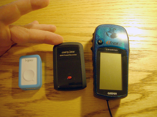
As can be seen in the photo above, the Qstarz (middle) is a good bit larger than the i-gotU, but still smaller than my Garmen eTrex. It’s still small enough to slip into a pocket, and it comes with a protective cover that has a belt loop.

Read More “One More GPS Tracker – Qstarz BT-Q1000” »

Posts pagination

Previous 1 … 12 13 14 … 21 Next

Categories

  • EdTech (197)
  • Entertainment (202)
  • Family (124)
  • Gear (114)
  • General Technology (98)
  • Geocaching and Maps (208)
  • History and Genealogy (276)
  • Internet (142)
  • Local (459)
  • Miscellaneous (561)
  • Music (202)
  • Paddling (268)
  • Photography (782)
  • Podcast (21)
  • Rambling (234)
  • Rants (162)
  • Recipes (37)
  • Religion (48)
  • Restaurants (165)
  • Science (48)
  • Things Overheard (29)
  • Travel (413)
  • Uncategorized (144)
  • Washington Sabbatical (113)
  • Weirdness (61)

Recent Posts

  • A Trip to Lando
  • Carolina Ghost Towns – Fort Motte, South Carolina
  • Carolina Ghost Towns Season 3 Trailer
  • Thanksgiving at Home
  • Home!

Recent Comments

  • Virginia Pepper on A Trip to Lando
  • julie niemeyer on Perryville Pickin’ and Grinnin’
  • Heath H Cowart on The Haunting of Farr’s Bridge
  • Sheryl Gunter Bingham on Chasing the Swamp Rabbit – Part 3, Sievern and Edisto Academy
  • Jerome A Mann on Update on Ghost Town Research

Tags

blogging cemetery Christmas Columbia Edisto River edtech Entertainment family Flickr Florida Furman Furman University gear Georgia geotagging Ghost Town Ghost Towns Google Earth Google Maps GPS Greenville Greenville Chorale history Instructional Technology kayaking Lake Jocassee LCU Lowcountry Unfiltered maps Music North Carolina Paddling Photography rambling restaurant Restaurants review singing social networking South Carolina time-lapse Travel video Washington Washington State
January 2026
S M T W T F S
 123
45678910
11121314151617
18192021222324
25262728293031
« Dec    

Copyright © 2026 Random Connections.

Theme: Oceanly by ScriptsTown