Skip to content

Random Connections

A collection of photography and exploration focusing on Upstate South Carolina and beyond.

  • Home
  • About Us
  • Photos
  • Resources
  • Other Voices
  • Post Archives
  • Home
  • Geocaching and Maps
  • Super Geotagged

Super Geotagged

Posted on April 28, 2008 By Tom No Comments on Super Geotagged
Geocaching and Maps, Photography

SuperGeotagged

One of the problems with native KML support in Flickr is that it only displays the last 20 geotagged images from the specified search criteria. If you want a more inclusive display of Flickr geotagged images, you need to use something like Metaltoad, Flyr or Loc.alize.us. Flyr gives you better granularity of control for searches based on tags, users, etc., and Metaltoad displays all geotagged images – good or bad – based on theA level of “interestingness” as determined by Flickr. Loc.alize.us uses Google Maps, and will sort according to date or interestingness. It provides clickable links for tags in its display.

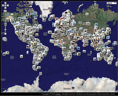
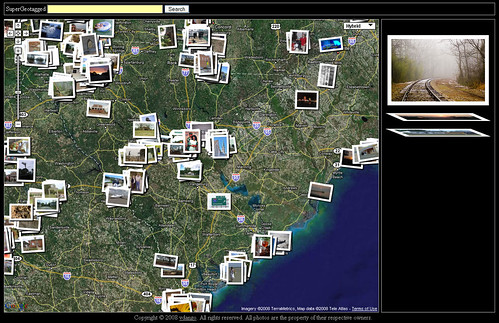
Now there is a new player in the geotagging field. Supergeotagged displays all geotagged images in Flickr on its map. These are displayed as thumbnail overlays on a Google Map, and as you can see in the image above, the effect is rather impressive. Images in the same location are shown as layers, as can be seen by this image zoomed into South Carolina.

SuperGeotaggedSC

The display is very impressive, and certainly gets across the concept of geotagging. I wish I’d had this available when I was teaching my classes last week. However, as far as functionality is concerned, there is not very much “super” about it. Sure, it displays all geotagged images from Flickr, but there is no way to sort or filter apart from zooming into an area, and there is no way to export the data to a KML file. Regardless, I think it’s a great effort, and I’m happy to see more and more people developing ways to view geotagged images from Flickr.

[tags]Supergeotagged, Google Earth, Google Maps, Flickr, geotagged, photography[/tags]

Tags: Flickr geotagged Google Earth Google Maps Photography Supergeotagged

Post navigation

❮ Previous Post: An Anniversary Dinner & Movie
Next Post: Hey! What’s That? ❯

Leave a Reply Cancel reply

Your email address will not be published. Required fields are marked *

This site uses Akismet to reduce spam. Learn how your comment data is processed.

Categories

  • EdTech (200)
  • Entertainment (201)
  • Family (120)
  • Gear (115)
  • General Technology (99)
  • Geocaching and Maps (208)
  • History and Genealogy (260)
  • Internet (144)
  • Local (449)
  • Miscellaneous (544)
  • Music (194)
  • Paddling (245)
  • Photography (779)
  • Podcast (6)
  • Rambling (226)
  • Rants (160)
  • Recipes (34)
  • Religion (48)
  • Restaurants (165)
  • Science (48)
  • Things Overheard (29)
  • Travel (410)
  • Uncategorized (129)
  • Washington Sabbatical (113)
  • Weirdness (60)

Recent Posts

  • Wilkinsville and a Mystery Church
  • A Farewell to the Greenville Chorale
  • Edisto River from Good Hope to Sullivan’s Landing
  • Paddling Lake Monticello
  • The Remnants of the City

Recent Comments

  • Kim Atchley on Journey to Nazareth
  • Tom on About Us
  • drew seibert on About Us
  • Doris Street on Orphaned Graveyards and Family Connections in Ninety Six
  • Tim Cathcart on Wilkinsville and a Mystery Church

Tags

blogging cemetery Christmas Columbia Edisto River edtech Entertainment family Flickr Florida Furman Furman University gear Georgia geotagging Ghost Town Ghost Towns Google Earth Google Maps GPS Greenville Greenville Chorale history Instructional Technology kayaking Lake Jocassee LCU Lowcountry Unfiltered maps Music North Carolina Paddling Photography rambling restaurant Restaurants review singing social networking South Carolina time-lapse Travel video Washington Washington State
May 2022
S M T W T F S
1234567
891011121314
15161718192021
22232425262728
293031  
« Apr    

Copyright © 2022 Random Connections.

Theme: Oceanly by ScriptsTown