Skip to content

Random Connections

A collection of photography and exploration focusing on Upstate South Carolina and beyond.

  • Home
  • About Us
  • Photos
  • Resources
  • Other Voices
  • Post Archives
  • Home
  • Google Earth

Tag: Google Earth

Jocassee Falls – A Preview

Posted on July 1, 2012 By Tom 2 Comments on Jocassee Falls – A Preview
Gear, Geocaching and Maps, Paddling

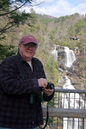
Houston at Whitewater Falls

My brother, Houston, recently informed me that he starts feeling anxious when I don’t update this blog often enough. I’m afraid I’ve given him ample reason to be irritated over the last week or so. I just haven’t had much about which to write. The usual excuses apply – work has been nightmarish, Laura’s sister and mother have been visiting, and a massive heat wave have combined to keep me away from any explorations this week. OK, so maybe those aren’t so usual.

Regardless, I’ve still got several projects in the works. So, to allay Houston’s anxiety I’ll provide a sneak preview…
Read More “Jocassee Falls – A Preview” »

If you build a dam here…

Posted on June 26, 2012 By Tom 5 Comments on If you build a dam here…
EdTech, Geocaching and Maps

Lake Union 1

While kayaking on Parr Shoals Reservoir last Saturday, Alan and I started discussing lakes in general. Specifically we were talking about the placement of dams and the hydrology of water backing up to fill in the space. We laughed at one of the last scenes of “O Brother, Where Art Thou“, where the lake comes flooding in as a torrent, rather than rising gently as it should. As far as movies go, “Deliverance” was a more realistic view of how lakes are created.

As the conversation proceeded, I reminisced about the time I participated in the SC-MAPS project when I was a teacher. This was a three-day workshop where we learned how to use topographic maps and satellite imagery in the classroom. This was long before the days of Google Earth, so the ability to look at overhead images of where you live was still a novelty.

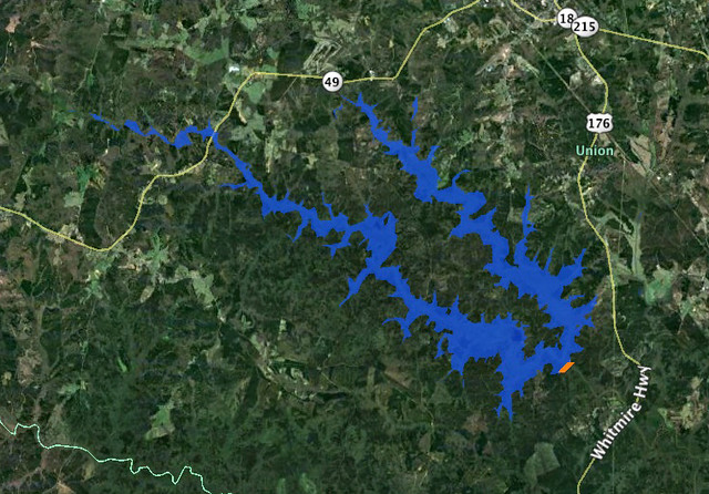
One of the activities they had us do was to draw a line across a river connecting contour lines at the same height. This line would represent a dam. Then we were to trace the contour line at that level all the way around, outlining the area that would be inundated by the new lake. It was a tedious process, but the results were fascinating. The lakes always turned out much larger than we expected.

As Alan and I talked, we wondered if there was some automated way to do this using Google Earth, so when I got home I started searching for a method. The automated systems I found were complex, requiring advanced knowledge of ArcGIS, hydrology, and GIS techniques in general. Even so, I think I’ve found a simple way in Google Earth. Here’s how…

Read More “If you build a dam here…” »

Local Paddling Venues

Posted on June 10, 2012 By Tom 1 Comment on Local Paddling Venues
Local, Paddling

After a spring full of multiple paddling trips, some on consecutive Saturdays, we finally had a weekend to ourselves with no paddling trips planned. Well, actually, I could have gone with my Lowcountry Unfiltered friends to Little Tybee Island on Saturday, but Laura and I really needed a weekend to ourselves at home. Even so, … Read More “Local Paddling Venues” »

Google Earth and Google Plus

Posted on February 15, 2012 By Tom 1 Comment on Google Earth and Google Plus
Geocaching and Maps, Internet

I hadn’t realized how far behind the times I’ve been with Google Earth until I ready on Frank Taylor’s blog that there is an update out for a version beyond the one I’m using. That means I’m two versions behind. Version 6.2 makes some changes to the overall appearance of the map, with a “pretty … Read More “Google Earth and Google Plus” »

Matching Reality to Google Earth

Posted on August 3, 2011 By Tom No Comments on Matching Reality to Google Earth
Geocaching and Maps

In Flight Photos-2

No matter how many times I’ve flown, the concept of this massive machine lifting into the air still strikes me as weird. I’m still fascinated. And unlike those jaded fliers who prefer the aisle seats, I still like to look out the windows at both the ground below and at unique cloud formations.

This summer I took a couple of trips across country, so I’ve had plenty of opportunity to look out windows. On the past several trips it’s struck me how similar the view is to Google Earth, and I began to wonder if I could match up locations with the same spots in Google Earth.

So, I grabbed my camera and started snapping out the window, trying to see if this could be done. Turns out it’s much, much harder than you might think.

Read More “Matching Reality to Google Earth” »

Quick Update

Posted on August 1, 2011 By Tom 2 Comments on Quick Update
Miscellaneous

I really hate these kinds of “weekend update” types of posts, and only do them as a last resort.  I feel that little blurbs about my day-to-day activities are best left to Twitter, Facebook and the like, where I would deeper explorations here.

Regardless, the last week of July is always a nightmare, and I haven’t had much of a chance to catch my breath, much less write a long blog post.  Here, then are a few things that have happened recently, for those that might be remotely interested…

Read More “Quick Update” »

Where were you born?

Posted on July 11, 2011 By Tom No Comments on Where were you born?
EdTech, Geocaching and Maps, Internet

Dear Twitterites, Facebook Friends, Google Plussers, and RandomConnections Readers: I need your help with a project.  This summer I’m doing several workshops for SCETV on Google products, including Google Earth and Google Docs. I’m hoping to include some information on Google Fusion Tables as part of the workshop, and in order to do that I … Read More “Where were you born?” »

More on Elevation Profiles

Posted on April 27, 2011 By Tom No Comments on More on Elevation Profiles
EdTech, Geocaching and Maps

A couple of posts back I wrote about discovering Elevation Profiles for Paths in Google Earth. I’ve spent a little bit more time working with this, and came up with another neat activity for a classroom.

In the last post I created a path with only two endpoints – basically a straight-line cross section. I also did this across fairly large areas of land, entire states, in fact. This activity focuses in on the details a bit, and uses the directions section of Google Earth.

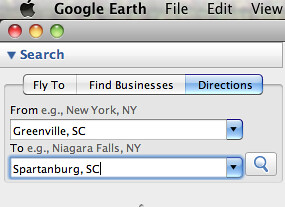
First, go to the Directions tab and input two locations. These can be addresses, lat-long coordinates, or any other type of locator. For this activity, I suggest keeping the distances fairly short, probably within about 50 miles. Here are some suggestions:

  • From your home to your school, workplace, or church
  • Between two cities
  • Between your house and your best friend’s house

In the example below, I used Greenville and Spartanburg.

Screen shot 2011-04-27 at 6.17.33 AM

When you hit Enter or click on the magnifying glass search icon, you get driving directions between the two cities. For some strange reason Google Earth chose Wade Hampton Boulevard instead of I-85. I guess it went with the shortest route rather than the quickest. No matter – I can still illustrate the point.

Read More “More on Elevation Profiles” »

Elevation Profiles in Google Earth

Posted on April 18, 2011 By Tom 4 Comments on Elevation Profiles in Google Earth
EdTech, Geocaching and Maps

File this one under “How the heck did I let this one slip past me?” I’ve just discovered Elevation Profiles for Paths in Google Earth. I have no idea when this became a part of Google Earth (years ago?) but I came across this feature as I was plotting my river routes for my Backyard to Ocean post.

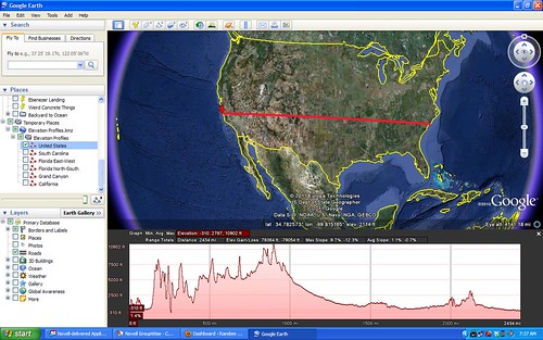
For any given path in Google Earth, you can select Elevation Profile and it will display a graph showing the rise and fall of that path from sea level. This works for ANY path, regardless of length or the number of anchor points. For demonstration sake, though, I like to use a path with only two anchor points – a beginning and and end.

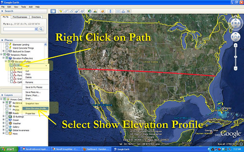
Let’s say, for example, that you create a straight line path across the continental United States. You have two anchor points – one on the west coast, and one on the east coast. Your path would look something like this…

US Selection

Once you have saved that path to My Places, you can right click on the path and select Show Elevation Profile from the menu. That would give you a graph like this…

United States

Read More “Elevation Profiles in Google Earth” »

Old School Charm

Posted on July 18, 2010 By Tom 8 Comments on Old School Charm
Geocaching and Maps, History and Genealogy, Local

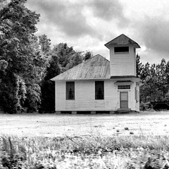
Old Shiloh School Textured

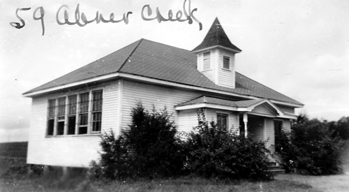
Perhaps it’s that I’m the son of a school principal, and had run of the various schools that I attended growing up. Perhaps it was the many reunions and covered dish suppers our family attended in various country community centers. Perhaps it was even because I spent college summers working maintenance – painting and waxing all of the schools in our district. It might, in some small part, have something to do with my own long career as an educator. Whatever the reason, I’ve always had a fascination with school architecture. Just about any school can be interesting, but what catches my attention most are the old wooden framed country schools.

Driving through the country these are easy to spot. The architecture is distinctive. The buildings tend to be squarish with hipped roofs. If it’s got an old bell tower, all the better.

Wheeland SchoolFish SchoolGowensville School HDR

Well, OK, they don’t all have to be white frame. There are some cool old brick schools, too.

Recently I was doing some research on the South Carolina State Archives website. There is a marvelous collection of photographs of old schools taken between 1935-1950 for insurance purposes.

Browsing this collection got me thinking about these old schools. They are great subjects for photography, and an excellent symbol of a bygone time. I wanted to see if I could find more of these old schools, and that meant making a list of potential targets using Google Earth.

Read More “Old School Charm” »

Posts navigation

1 2 … 5 Next

Categories

  • EdTech (200)
  • Entertainment (202)
  • Family (121)
  • Gear (115)
  • General Technology (99)
  • Geocaching and Maps (208)
  • History and Genealogy (266)
  • Internet (144)
  • Local (451)
  • Miscellaneous (550)
  • Music (196)
  • Paddling (248)
  • Photography (779)
  • Podcast (6)
  • Rambling (227)
  • Rants (161)
  • Recipes (34)
  • Religion (48)
  • Restaurants (165)
  • Science (48)
  • Things Overheard (29)
  • Travel (411)
  • Uncategorized (129)
  • Washington Sabbatical (113)
  • Weirdness (60)

Recent Posts

  • In Search of the Road Builder
  • The Phoenix Riots and Dr. Benjamin Mays – An MLK Day Ramble
  • An Obsession with Steak Knives
  • An Epiphany on Patriotism
  • Kayaking Bates Old River and Running Creek

Recent Comments

  • Walter Kokoszka on Mysterious Mayucha and The Wolf Pit
  • Elizabeth on The Temple of Health: Ground-Truthing in Antreville
  • The Bay Area Basketball Fan’s Guide to March Madness on FU All the Time!
  • Why You Should Root For This March Madness Underdog on FU All the Time!
  • Gregory Davis on Ghost Towns of the Pee Dee – Part 2, Centenary

Tags

blogging cemetery Christmas Columbia Edisto River edtech Entertainment family Flickr Florida Furman Furman University gear Georgia geotagging Ghost Town Ghost Towns Google Earth Google Maps GPS Greenville Greenville Chorale history Instructional Technology kayaking Lake Jocassee LCU Lowcountry Unfiltered maps Music North Carolina Paddling Photography rambling restaurant Restaurants review singing social networking South Carolina time-lapse Travel video Washington Washington State
March 2023
S M T W T F S
 1234
567891011
12131415161718
19202122232425
262728293031  
« Jan    

Copyright © 2023 Random Connections.

Theme: Oceanly by ScriptsTown