Skip to content

Random Connections

A collection of photography and exploration focusing on Upstate South Carolina and beyond.

  • Home
  • About Us
  • Photos
  • Resources
  • Other Voices
  • Post Archives
  • Podcast
  • Home
  • Photography
  • Page 21

Tag: Photography

Saluda Lake, Take Two

Posted on July 4, 2010 By Tom 1 Comment on Saluda Lake, Take Two
Local, Paddling, Photography

Saluda River

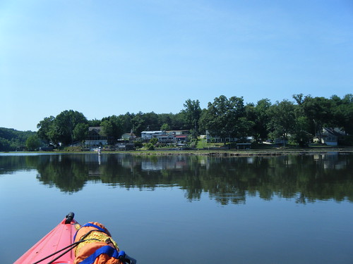
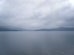
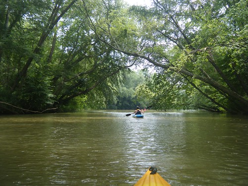
When Alan and I came out to Lake Saluda last week, I wasn’t feeling so hot. Well, actually, I was too hot – heat exhaustion plus a fever of over 100. Couple that with the fact that we missed the channel we were supposed to be taking, and it wasn’t an ideal trip. So, when Dave Freeland called and wanted a close paddling venue that would be good for his 13 year old son, Zach, I suggest heading back to Saluda.

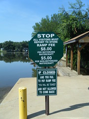
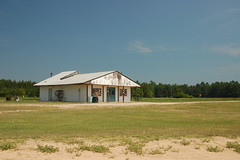
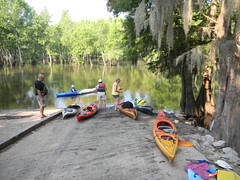
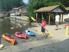
We made our way back down Motor Boat Club Road to Saluda Landing. Personally, I would love to find some other access point. These guys charge per boat, so to launch our three kayaks was $15. I don’t mind paying a parking fee, but the per boat fee is a bit steep. However, they have a monopoly on lake access, and they know it.

Zach and DaveZach Launches

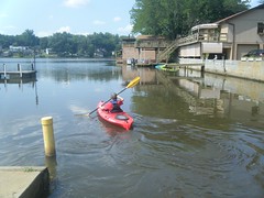
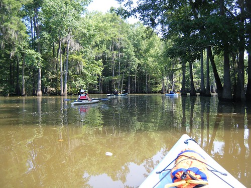
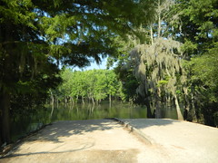
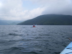
We paddled out, then southward to avoid the silted spit, then turned upstream. This time we hugged the right channel toward the river, rather than being tempted by the more open water of the west arm of the lake.

Read More “Saluda Lake, Take Two” »

Paddling Lake Saluda

Posted on June 26, 2010 By Tom 5 Comments on Paddling Lake Saluda
Paddling, Photography

Saluda Lake Siltation

When I mention Saluda Lake to my acquaintances, many don’t even know it exists. They usually reply, “Don’t you mean the Saluda River?” Or, they try to correct me by naming one of the many other lakes fed by the Saluda. Most don’t seem to be aware that there is a rather large lake on the west side of Greenville with that name.

I can see why Saluda Lake is overlooked. While it’s a nice lake, the banks are almost completely built up, and there is very little public access. There is limited access right at the dam, but no place where one could easily launch a boat. The only boat ramp is on the north end of the lake on Motor Boat Club Road. It’s privately owned, and the signs make you think the owners are somewhat less that friendly.

And we mean it!

Despite the limited access, Alan and I decided to give it a shot. The lake is relatively close, and I’d never been on it. The plan was to put in at the one boat ramp then paddle north up the Saluda River to at least Farr’s Bridge on Highway 183. For a variety of reasons, we didn’t quite make it that far.

Read More “Paddling Lake Saluda” »

Image-Stacking in Charleston

Posted on June 26, 2010 By Tom No Comments on Image-Stacking in Charleston
Photography, Travel

Guitarist

It’s been a very long, hard two weeks. Right after the funeral on Monday I drove straight down to Charleston for PowerSchool University – an intense training session on our new student database system. I learned some neat things I’m going to try when I get back to the office, but it was almost information overload. I did manage to sneak out for a couple of hours one evening to do some photography, and was keen to try out the new image-stacking techniques, as well as the content-aware fill tool in Photoshop CS5.

My friend Ken had given me the idea to use image stacking with crowd scenes. The idea was that there would be a blur of activity around a few static individuals. Since I was staying in the heart of Charleston’s tourist area, I figured I’d have ample opportunity to give this a try. Turns out it was a nice idea, but the process in Photoshop probably wasn’t the best choice of tools.

Read More “Image-Stacking in Charleston” »

Focus-Stacked Macros

Posted on June 22, 2010 By Tom 7 Comments on Focus-Stacked Macros
Photography

Lilly Focus Stacking

Last summer when we were in Maine one of the people staying at the B&B with us was also a photographer. Over breakfast one morning he told me about image focus stacking. The technique is similar to HDR photography, but instead of exposure, different images with various focus and depth of field are combined. Several shots are taken at various focal lengths, and the images are “stacked”, taking the best focused areas from each image to create a very sharp final image.

When I got home from Maine I downloaded Keith’s Image Stacker . Keith Wiley does astrophotography, and wrote the software to sharpen some of his images. I know some people who have gotten excellent results from his program, but I just couldn’t seem to get the hang of it. I lost interest. Last week I upgraded to Photoshop CS5, which has built-in image stacking, and my interest was renewed.

Read More “Focus-Stacked Macros” »

Sparkleberry Swamp

Posted on June 15, 2010 By Tom 1 Comment on Sparkleberry Swamp
Paddling, Photography

Sparkleberry Channel

I had been wanting to paddle Sparkleberry Swamp for quite awhile, but always seemed to miss opportunities. I had a solo trip planned for a couple of months ago, but had to cancel when my cat suddenly got ill. I did Jocassee instead. Another trip was planned for a month later, but we canceled because one of our paddlers got ill (we did Jocassee instead.) Several of the Greenville group were staying over after the Pinopolis Lock paddle and heading up on Sunday to paddle Sparkleberry, and this time it didn’t look like anyone was going to get ill, and we were nowhere near Jocassee, so I finally got my chance.

Sparkleberry Swamp, also known as Rimini Swamp, isn’t a natural swamp. It was formed when Lake Marion was created and the forests of the upper Santee River were flooded. Its boundaries are nebulous, depending on water levels and who you ask. Even though it’s not a natural swamp, it has all the characteristics of one. If you picture in your mind what a southern swamp is supposed to be, it probably looks a lot like Sparkleberry.

I spent the night in the town of Santee in a dumpy little motel that deserves its own blog post. Maybe, after therapy, I’ll write that one up. Our group met at the local Bojangles for breakfast, then crossed Lake Marion on I-95, then headed north along the east shore.

This part of the state is about as desolate as it gets. It’s on the lower edge of the Carolina sand hill region, so pine forests and sandy soil are the norm until you reach the actual swamp. We passed through the towns of Summerton and Rimini, which I didn’t even know existed.

When we got to Sparkleberry Landing it was already sweltering. The water was high, and even at the landing the scenery was fantastic. We unloaded the boats and were soon underway.

One of our group of seven had been to the swamp several times before, and served as our guide. It was a good thing. I would have followed the more open channels either north or south, and would have missed the real path through a narrow stand of trees. I was glad I had a functioning GPS and spare batteries.

Read More “Sparkleberry Swamp” »

Paddling the Pinopolis Lock

Posted on June 13, 2010 By Tom 4 Comments on Paddling the Pinopolis Lock
Paddling, Photography

Pinopolis Lock

I had two conflicting paddling opportunities this weekend. My buddies from Lowcountry Unfiltered were going to be paddling the lower Savannah River, and the Greenville Canoe and Kayak group were planning a paddle on Lake Moultrie through the Pinopolis Lock. It was quite the dilemma. Ultimately I decided on the Pinopolis Lock trip because it sounded more like a one-shot deal.

I had seen photos and even a couple of online videos of the Pinopolis Lock. The lock is the highest single-stage lock in the US, and the second-highest in the world. It raises and lowers boats 75 feet from Lake Moultrie to the Tail Race Canal, which then connects to the Cooper River and on to Charleston.

We wouldn’t be paddling quite that far, though. Our plan was to launch from the YMCA beach near the dam, paddle about a mile to our lunch spot, then enter the lock. We would then do a few miles on the canal, then cut back into Wabdoo Creek to our take-out.


View Lake to Lock Paddle in a larger map

Read More “Paddling the Pinopolis Lock” »

Lake Jocassee Waterfalls

Posted on May 23, 2010 By Tom 2 Comments on Lake Jocassee Waterfalls
Paddling, Photography

Dramatic Jocassee

The original plan for today was to paddle Sparkleberry Swamp at the upper end of Lake Marion. However, one of our fellow paddlers fell ill, and he was the one who had suggested the trip. While Sparkleberry would have been great, we used this as an excuse to stay a bit closer home, so Alan and I headed back up to Lake Jocassee.

The weather was not cooperating. I loaded the kayaks into the truck in a light sprinkling of rain, which increased to a downpour just after I got them tied in. It didn’t help that I found a bird’s nest in one of my boats. This is especially weird since I had used that same kayak just two weeks ago. This nest was complete, with broken eggs. Those birds must have been busy. Since the nest looked abandoned and broken I didn’t mind removing it.

It rained on us just a bit more as we drove up to Jocasee, but by the time we got there the rain had ended. There were clouds and fog, but it looked like we would be OK weather-wise.

Read More “Lake Jocassee Waterfalls” »

Charleston to McClellanville and Beyond

Posted on May 17, 2010 By Tom No Comments on Charleston to McClellanville and Beyond
Photography, Travel

Sewee Shell Ring Boardwalk HDR

So far we had already had a great trip to the South Carolina Low Country. Yesterday we explored Beidler Forest and the ACE Basin, and the weather looked great for more exploration today.  The day was already hot and humid, so we decided it would be more of a driving trek than hiking.  The trek took us through a large swath of the Francis Marion National Forest.

We started the day by driving onto the Charleston peninsula and touring the area South of Broad. There was the obligatory drive along the battery, but what we enjoyed most was driving through the residential areas and looking at the stately homes with their enclosed gardens.  For some reason, I wasn’t in much of a photography mood, so I don’t have any photos of that part of the trip.

From Charleston we crossed the new Cooper River Bridge into Mount Pleasant, then headed north on Highway 17.    Eventually we came to the Cape Romaine National Wildlife Refuge.  I had already checked online, and the ferry out to Bull’s Island doesn’t run on Sundays, so we walked out to the pier and watch birds and boat traffic out on the ICW.

Read More “Charleston to McClellanville and Beyond” »

ACE Basin

Posted on May 17, 2010 By Tom No Comments on ACE Basin
Photography, Travel

Donelley House

Our visit to Beidler Forest only took up half of the day, and we were ready to see more wildlife. Therefore, we cut across the country down toward the ACE Basin and the Donnelley Wildlife Management Area. Donnelley is only one small section of the ACE Basin. To the east is the Ernest Hollings National Wildlife Refuge. However, we prefer Donnelly because it’s a bit easier access, and it tends to be a bit quieter.

We entered from Bennett’s Point Road and immediately got turned around. We were taking a different direction, but eventually wound up where we wanted – at the old farm house that serves as a landmark for the rice field hiking trails.

Read More “ACE Basin” »

Francis Beidler Forest

Posted on May 17, 2010 By Tom 1 Comment on Francis Beidler Forest
Photography, Travel

Beidler Forest Boardwalk

I had been sneaking off on paddling trips for the past several weekends, so Laura decided it was time for both of us to get away. We headed down toward the coast, and one of our favorite locations, Francis Beidler Forest.

Beidler Forest is located in the Four Holes Swamp area, and is maintained by the Audobon Society. It features a mile-long loop trail on a raised boardwalk that winds through the cypress swamp. In addition to huge ancient trees, the swamp is home to many species of birds and other wildlife. This time of year is when the prothonotary warblers are in town, and we were hoping to spot a few.

Read More “Francis Beidler Forest” »

Posts pagination

Previous 1 … 20 21 22 … 29 Next

Categories

  • EdTech (197)
  • Entertainment (202)
  • Family (123)
  • Gear (114)
  • General Technology (98)
  • Geocaching and Maps (208)
  • History and Genealogy (275)
  • Internet (142)
  • Local (459)
  • Miscellaneous (560)
  • Music (202)
  • Paddling (268)
  • Photography (781)
  • Podcast (19)
  • Rambling (233)
  • Rants (162)
  • Recipes (37)
  • Religion (48)
  • Restaurants (165)
  • Science (48)
  • Things Overheard (29)
  • Travel (413)
  • Uncategorized (143)
  • Washington Sabbatical (113)
  • Weirdness (61)

Recent Posts

  • Helene One Year Later
  • Once Again, Up the Long Nose
  • Upstate Renaissance Faire
  • Exploring Lake Summit
  • The End of Days

Recent Comments

  • Gay on In Search of the Road Builder
  • Virgil Howell on The Ghost Towns of Lake Marion
  • Virgil Howell on Return to Ferguson
  • Mary Copeland Myers on Renno and Stomp Springs
  • Virginia Pepper on Helene One Year Later

Tags

blogging cemetery Christmas Columbia Edisto River edtech Entertainment family Flickr Florida Furman Furman University gear Georgia geotagging Ghost Town Ghost Towns Google Earth Google Maps GPS Greenville Greenville Chorale history Instructional Technology kayaking Lake Jocassee LCU Lowcountry Unfiltered maps Music North Carolina Paddling Photography rambling restaurant Restaurants review singing social networking South Carolina time-lapse Travel video Washington Washington State
October 2025
S M T W T F S
 1234
567891011
12131415161718
19202122232425
262728293031  
« Sep    

Copyright © 2025 Random Connections.

Theme: Oceanly by ScriptsTown