Long
Long before Google Earth came on the scene there was ArcGIS from ESRI. There are two (actually, multiple) flavors of this. There were the professional GIS versions consisting of ArcMAP and ArcServer, and a free viewer, ArcExplorer. I attended a couple of workshops on ArcExplorer, was impressed by its potential for the classroom, but never really got into it. Along came Terraserver making free satellite imagery available, then Google Earth took the world by storm, somewhat obscuring these previous free mapping services.
While working on another project I needed to check out ArcGIS Explorer once again, and was surprised to find that it now looks very much like Google Earth with a similar user interface. Navigation is essentially the same – you can zoom in, tilt, and pan just like in GE. There are search functions and you and create placemarks. While Explorer will open KML files, it’s designed to be more compatible with ArcGIS data.
Google Earth has a much larger user-contributed base. However, there is much more accurate GIS data available for Explorer from various GIS organizations around the world. When comparing the free versions of these programs, you could think of Google Earth as being more populist, and ArcGIS Explorer as more professional.
There are many other differences between the two programs that I won’t get into here. The most striking thing I found was what is not available in Google Earth that is available in Explorer. For example, on one of our photo journeys Houston and I drove through an area near Belton, SC that has lots of fuel storage tanks. Apparently this is a gasoline distribution center of some sort. It covers a large area, and we wanted to look it up, so we tried to find it in Google Earth. The image below is what you see in GE…
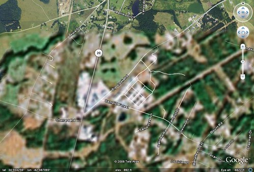
Note the top of the image. It’s much more detailed, while the area below has been blurred out. The prominent white blob on the middle left are the fuel storage tanks. This blurring is only around the tanks – everywhere else is in high resolution.
Now look at the same area in ArcGIS Explorer:
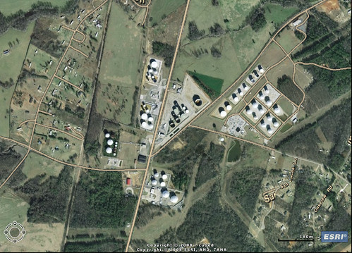
The tanks are clearly visible.
Seeing this, I was curious to check out another location that Google Earth blurs out, namely, the National Observatory and home to the Vice President. Here’s the image in Google Earth:
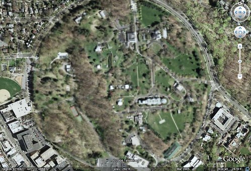
You may want to click on the image to see it, but all of the details are pixelated out. Here’s the same image in ArcGIS Explorer, which is very clear:
So I guess the moral of this story is that if you’re a terrorist plotting against either Belton, SC, or the Vice President, Use ArcGIS Explorer instead of Google Earth. Of course, this also highlights the silliness of trying to block these images in Google Earth. before Google Earth came on the scene there was ArcGIS from ESRI. There are two (actually, multiple) flavors of this. There were the professional GIS versions consisting of ArcMAP and ArcServer, and a free viewer, ArcExplorer. I attended a couple of workshops on ArcExplorer, was impressed by its potential for the classroom, but never really got into it. Along came Terraserver making free satellite imagery available, then Google Earth took the world by storm, somewhat obscuring these previous free mapping services.
While working on another project I needed to check out ArcGIS Explorer once again, and was surprised to find that it now looks very much like Google Earth with a similar user interface. Navigation is essentially the same – you can zoom in, tilt, and pan just like in GE. There are search functions and you and create placemarks. While Explorer will open KML files, it’s designed to be more compatible with ArcGIS data.
Google Earth has a much larger user-contributed base. However, there is much more accurate GIS data available for Explorer from various GIS organizations around the world. When comparing the free versions of these programs, you could think of Google Earth as being more populist, and ArcGIS Explorer as more professional.
There are many other differences between the two programs that I won’t get into here. The most striking thing I found was what is not available in Google Earth that is available in Explorer. For example, on one of our photo journeys Houston and I drove through an area near Belton, SC that has lots of fuel storage tanks. Apparently this is a gasoline distribution center of some sort. It covers a large area, and we wanted to look it up, so we tried to find it in Google Earth. The image below is what you see in GE…
Note the top of the image. It’s much more detailed, while the area below has been blurred out. The prominent white blob on the middle left are the fuel storage tanks. This blurring is only around the tanks – everywhere else is in high resolution.
Now look at the same area in ArcGIS Explorer:
The tanks are clearly visible.
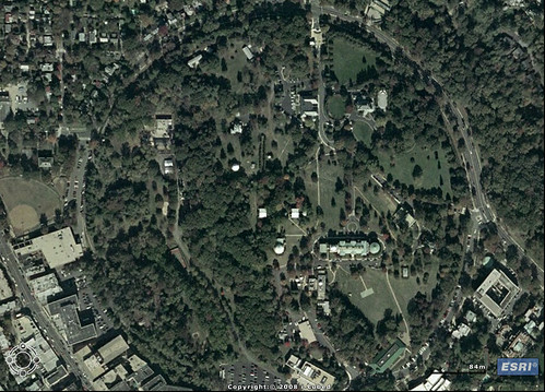
Seeing this, I was curious to check out another location that Google Earth blurs out, namely, the National Observatory and home to the Vice President. Here’s the image in Google Earth:
You may want to click on the image to see it, but all of the details are pixelated out. Here’s the same image in ArcGIS Explorer, which is very clear:
So I guess the moral of this story is that if you’re a terrorist plotting against either Belton, SC, or the Vice President, Use ArcGIS Explorer instead of Google Earth. Of course, this also highlights the silliness of trying to block these images in Google Earth.
It’s disturbing that the images are apparently blocked in Google Earth, but I don’t recall seeing anything that would indicate such a policy. Further, the large naval bases, like Mayport or the shipyard in Newport News, is clear as a bell. Rather strange.
I did a check on Oconee Nuclear plant and it is clear in Explorer while blurred in GE. Like you pointed out, doesn’t make much sense. Interesting software but I think I prefer GE because I’m familiar with it.
I didn’t check Oconee, but I figured it would be the same. As for the software, I’m the same way. The GE interface seems a little smoother and a bit more user-friendly. However, there are some things Explorer will do that the free version of GE won’t, and I’ll use it for those limited applications.
On another note, if you look at the White House in Google Earth it appears clear. They get around the blurring by using older imagery that doesn’t include the defense systems located on the top of the building. Same for the Capitol Building, which also used to be blurred in GE.
Maybe I missed something, but when i went to their site, I couldn’t make heads or tales of their software offerings. I have a PC at work (they don’t advertise a Mac version), but I didn’t see anything that indicated what software would run. But, I’m not an IT guy, and don’t think in terms of putting together modules and whatnot.
I have noticed little pockets of low res stuff on Google Earth, but am not sure I attribute it to censorship. My dad did point out, when we talked about this imagery, how valuable it could be to someone wanting to do mischief. Not sure I’d censor in order to protect against that, but I’m not sure that my attitude would differ if protection was my job.
The censorship is a documented fact. In the case of the National Observatory, one perfect circle is pixelated – everything else is clear. Likewise with the Belton site and several others. Here is a site that has a list of censored locations.
I liked the one comment on the circle at the Naval Observatory: “This circle is appearently blurred out due to it being the home the US vice president and the location of US Naval Observatory. But, then why isnt the White house censored?” The answer is obvious: you censor the center of power. 🙂
Disturbing, and yet another sign of our eroding liberties.
I agree – that one weird little feature of Google Earth, more than anything else, describes the state of things in Washington.
I took a look at some of these locations today. In addition to Keowee andBelton (haha), the Jocassee Dam was blurred. There’s a good deal of discussion on this blurring on the web. I was surprised that the tank farms in Camp Croft (SE Spartanburg) were not blurred, even though that seems a much bigger concentration. Chedder (near Belton) may be more important to shipping, though. Also, McGuire Nuclear (near Charlotte) was not blurred, though apparently a nearby place was (maybe a mistake). What really surpriesed me was that Yahoo Maps has a satalite imagery service with NO blurring that I could find. Further, the imagery was more up-to-date in some areas (SE jacksonville FL, Wilmington, WW Bridge S of DC), and the same as Google in others (and behind only on the Bay Bridge in SF/Oakland).
Some discussions attribute the Google problems to moves by the supplier of their imagery. However, with Google’s compliance with Chinese censorship laws, I wonder if they are not in fact to blame for this.