You would think that something that stands 100′ high would be easy to find. Certainly, when you’re close enough they are very visible. However, locating lookout tower sites on maps turns out to be harder than I had thought. I knew of several definite locations such as the Duncan Tower, Glassy Mountain, Paris Mountain, and the Big Knob. However, a complete listing of the towers is nowhere to be found. Furthermore, many of the towers that do appear on lists no longer exists, such as the Cleveland Tower north of Marietta.
I’ve been able to find several lists, and have been trying to combine these into one comprehensive listing. First there is the list created by the Forest Fire Lookout Association (FFLA) for South Carolina. This list has 154 sites, many simply labeled “Unknown.”
You can query the GNIS Name Server for the category “tower”, and that will return about 100 locations using either “lookout tower” or ‘fire tower” as a search term. The University of South Carolina’s GIS department has a listing of towers for the ArcGIS system, but this information seems to be identical to the GNIS data.
Both of these data sets, the GNIS data and the FFLA data, have advantages as well as flaws. The GNIS data is based on place name, so if the location doesn’t have the word “tower” in it, it doesn’t appear on the list. Therefore several of the most prominent towers, such as Paris Mountain, Glassy Mountain, and the Big Knob are not included on the GNIS. The FFLA data includes these sites, but the location information isn’t precise at all. While it does include the latitude and longitude, in only has degrees and minutes – no seconds. The GNIS locations are much more precise.
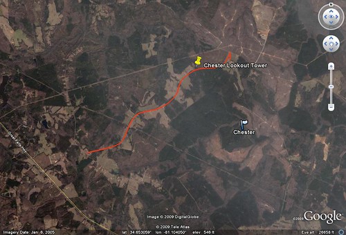
The image below illustrates this problem. The yellow pushpin shows the location for the Chester Lookout Tower in Chester County based on the GNIS data. The flag shows the location based on the FFLA data, which puts it about 1.3 miles away. The red line in the image is “Fire Tower Road”. Since the yellow pin is on that road, I’m guessing that is the more likely location. Obviously this endeavor is going to require some trial and error as well as hunting. I don’t even know if the Chester tower is still standing.
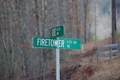
Speaking of “Fire Tower Road”, I found a lot of roads with this name in the state. Seems logical. But again, the names can be deceiving. For example, Firetower Road in Cleveland, SC now dead ends at a hunt club. The tower is no longer there.
One of the problems with creating these lists is a matter of ownership – who actually controls these towers. In cases it’s the South Carolina Forestry Commission. I think there might be some owned by the US Forest Service, but I haven’t been able to confirm that, and some had been constructed by private concerns. The SCFC has sold some of its towers. Some of these still stand in place, some have been dismantled, and some have been relocated. For example, in February of 2006 The State newspaper in Columbia reported that…
Charleston resident Tommy Hawkins recently bought himself an unusual birthday gift: two 100-foot lookout towers. One tower was dismantled from a Lake Murray site Monday, and the other in Ballentine is expected to start coming down today, his 68th birthday.
Hawkins is moving the towers to about 3,200 acres in Fairfield County, where he plans to retire. “I wanted to get out of the business and the city and get up into the country,” he said. As a child, he remembers climbing lookout towers for fun. He wanted to keep that memory alive, and he’s not alone. Today, lookout towers — once the primary method for spotting fires in wooded South Carolina — are being sold, mostly to individuals. In Richland and Lexington counties, six towers are up for sale or have been sold — for prices from $200 to $2,000.
The article goes on to say that the value of the 10-acre tracts that typically surrounded the towers has increased substantially, so that maintaining them even as “reserve space” becomes financially unviable.
As these locations are sold, the names may or may not be removed from the various lists that I have access to. Some towers that were put up privately to begin with may not be on my lists at all. For example, someone mentioned that there might be a tower at Camp Croft State Park in Spartanburg County. This was originally a military camp, and if there was a lookout tower, it would have been put up by the military and not the forest service, so it may not be on any of my lists.
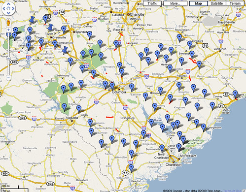
I did manage to combine all of the data that I’ve been collecting into one resource. I’ve got a master database that contains each list as a table. I’ve also included a table for all the roads in the state called “Fire Tower” or “Firetower” or “Lookout”. I took all of this data and plotted it on one master Google Earth KML file that I can update as I go along. Even though the FFLA data may not be accurate, it will get me to the general vicinity. Since everything is geocoded I can dump it all into my GPS units.
Of course the only way to really verify the data is to visit the locations. Sure, I could make a couple of phone calls and e-mails, and I’m sure I will be doing quite a bit of that as this project progresses. But it’s not nearly as fun as actually visiting the site and seeing what’s out there.


Tom,
I updated the FFLA South Carolina tower list earlier this year to include GPS coordinates with seconds, and we now list 179 locations. Plus I have an additional three that have not yet been added to the list (for a total of 182).
Sounds great, Ron! I’ll be sure to check it out.