This is going to be one of those multi-part posts. I’ve got tons of information on this subject, and it won’t be possible to put it all in one story.
I’ve always been fascinated by lookout towers. Near where I grew up in Laurens County there were two small monadnocks called the Little Knob and Big Knob. The Big Knob had a fire tower on it, and I longed to scale its steps and enjoy the view from the top. Some miles to the north is another prominent, larger monadnock with a fire tower – Paris Mountain. When I was around eight years old I did get to climb up the steps, but never made it into the cab at the top. I distinctly remember the trap door being padlocked when we got to the top.
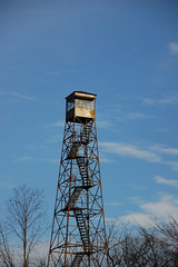
I had forgotten all about the towers until just this past week. I had been looking for locations to do long-exposure photographs of I-85 for traffic trails when I spotted the Duncan lookout tower on the way home from work on Friday. At the intersection of Danzler and Victor Hill Roads it had a perfect view of the Interstate, so I went to explore. I found the tower in the front yard of a house on Victor Hill Road. The fence around its base now had a dog house within, and it was clear that the tower had not been used in years. I gave up on using this location as a photography platform, but now I wanted to learn more about the towers themselves, so a new quest was born.
As soon as I got home I started doing a bit of research. I knew that most of these towers were no longer in use and falling into disrepair. I wanted to find out a bit of their history and if any were still being used.
The South Carolina Forestry Commission had some of the best initial information on their Pictures from our Past page…
South Carolina towers ranged from about 55′ tall (atop Sassafras Mountain in Pickens County) to 120′ tall. The taller towers were generally in the flatlands of the Coastal Plain.
Most tower sites consisted of 10 acres of land, the tower, and a year-round dwelling for the operator. The size of the property allowed tower operators to grow their own vegetables and feed for their domestic livestock. In the early days, most tower families had a milk cow, chickens, and raised a few hogs for their own use.
The tower operator €™s hours in the tower cab depended on the fire danger. If it was raining, they didn €™t go up at all; if danger was low, they might make a short check in the morning and afternoon; when danger was high, they might spend as much as ten hours per day in the cab.
When a smoke was spotted, each of two towers would record its direction using a large compass table and a sighting device called an alidade. The fire was located at the spot where these readings crossed when plotted on a map.
Towers were not routinely manned at night. During moderate to high danger, operators were required to make a “night check”, climbing the tower after dark to check for glows.
Towers were the public €™s fire reporting contact point, and served as the communications link for firefighters in the field.
From the 1960 €™s on, most South Carolina tower operators were women; frequently their husbands were employed as firefighters. In many cases, the tower became a family tradition, with adult children succeeding their parents as tower operators.
The page goes on to say that the tower system contributed to the spread of telephone service in rural areas.
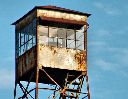
 The towers in South Carolina all have a similar appearance. Most of these were constructed by the Aermotor company, which was responsible for the iconic windmills found on farms across the United States and is still in operation today. The tower had two parts – the steel tower, built using the same steel engineering as the windmill tower, but on a larger scale, and a small cabin called a “cab”, which had a trap door in the bottom. The cabs were as small as 4″ X 4″, but were built up to 8″ X 8″. Most of the South Carolina towers have a 7″ X 7″ cab.
In 2003 The Sandlapper Magazine published a story about the towers (PDF). Mark Shaffer’s article quoted Ken Cabe, Information Officer from the State Forestry Commision…
The tower system worked very simply. Towers were built in a rough grid, based on visibility €”about 15 miles apart €”on the highest point of land available. The lower the land, the higher the tower and vice-versa. The tallest towers, up to 120 feet, were in the Low Country. The shortest, 54 feet, was in the upstate. Just a foot taller, the tower on Sassafras Mountain occupied the highest point above sea level in South Carolina.
With increased population density and the increase in aerial surveillance the towers fell out of use. By 1993 the Forestry Commission had decommissioned all towers. Now only about 60 or so still remain in possession of the Commission, and those are being used simply as space holders – retaining land that might be used for other tower space.
I feel just like Mr. Shaffer does when he states in his article that…
Occasionally, I drive past one of the old towers, standing like something out of Tolkien, ever watchful over the pulp pines and sand hills. The next time I pass by, I shall think of it as a monument to a nearly forgotten way of life and a timeworn truth: Where there €™s smoke, there €™s fire.
…and so I have a new mission. I want to visit these remaining sites and take pictures of them. If possible, I would love to arrange a visit that would allow climbing to the top and looking at the view from the interior of the cab. I don’t know if that is even possible now, with many of these now structurally unsound. I’ll document some of those visits here as I take the photos, and I invite any of my other fellow South Carolina explorers to come along for the ride.
To get started, I’ve placed my research notes from Google Notebook in a publicly available space. You can view those notes here, including links to other resources I didn’t quote in this post. I have also created a map from my South Carolina Placenames Database, searching on the terms “lookout tower” and “fire tower.”
- Map 1 – Lookout Towers
- Map 2 – Fire Towers
Since these two maps are based on place names, some sites, such as Big Knob, Paris Mountain, and Glassy Mountain in Pickens are not included. I hope to create one comprehensive map which includes these locations, along with notes about conditions, etc. It should be a fun project.

very interesting information! It reminds me a bit about light houses. A family would monitor it and live on the land.
I was thinking of those same light house/lookout tower parallels as I was writing this. Both are lonely jobs, etc. Of course, there is also the tower aspect.
Lookout towers tend not to be as photogenic as lighthouses, but to me they are every bit as interesting.
This is what I get when I read the top of the page/the most recent entry first. I missed all this background.
Ok, now I’m convinced that YOU should write a guide on SC lookout towers!
I’m flattered, especially with such high praise coming from a book vendor such as yourself, Laura. I might just have to write that book. We’ll see.
Two years ago I was driving from Columbia, SC to Athens, GA along back roads and came across the most amazing fire tower. You could climb to the top, and up there were old log books. I would love to go back, but I don’t know where it was exactly, and I’m hoping you can help me.
Based on the firelookout.org site and the route we most likely took, it seems there are firetowers in both Leesville and Saluda. The one we climbed was right on the road – we were literally driving by. I also have a photo of it, if that may help you identify it. Any help would be greatly appreciated!
I’m retired from the SC Forestry Commission (2000 – with 34 years of service) and I have some insights.
I agree with your artistic and nostalgic remarks. Although I did not climb them all, I had a “life list” and I ran to the top of everyone I ever visited. (And that was at least 50+.)
There was a need to place them on a prominence, but due to the flatness of the land they generally had to be 100′ tall to put them above the trees.
I spent two summers with the Forest Service in Washington state in the 60’s, and there the towers would be on mountain tops or ridges, but as short as 20′. They were 20′ x 20′ living spaces with a catwalk all around. (Not a place you want to be in a thunder storm.) Storms could be frequent, and the tower operator had a small stool with glass insulators on the bottom of each leg. The operator sat on the stool until the storm passed.
I helped build the last tower in South Carolina. It was Smith Tower in Lexington County, and it was the first tower removed. A great memory. It was pre-OSHA, with minimal safety gear – like monkeys on a frame. Homer Cook was the Ranger and he fed us Good.
As District Forester in Newberry, SC in the early 80’s, I was responsible for buying Big Knob Tower site. A thing I was most proud of. Prior to that, the Commission relied on the generosity of local landowners to provide tower sites.
Everyone doesn’t see the same thing. About 30 years ago as a member of the SC Public Relations Society, a group of us were riding from Hilton Head to Savannah. As we passed a tower, I remarked that “there was the most visible symbol” of the SC Forestry Commission. They didn’t know what I was talking about.
Thank you for this chance to reminisce and share. Rhett Bickley cell (803)622-2074