Skip to content

Random Connections

A collection of photography and exploration focusing on Upstate South Carolina and beyond.

  • Home
  • About Us
  • Photos
  • Resources
  • Other Voices
  • Post Archives
  • Podcast

Bad Creek Views

Posted on April 18, 2011 By Tom 2 Comments on Bad Creek Views
Local

The weather Sunday was beautiful, albeit a bit brisk. We decided that we needed to get out of the house for a bit, so Laura, her mother, and I hopped in the car for a drive and a picnic. We started by driving up scenic Highway 11 past Table Rock, then on up toward Lake … Read More “Bad Creek Views” »

Elevation Profiles in Google Earth

Posted on April 18, 2011 By Tom 4 Comments on Elevation Profiles in Google Earth
EdTech, Geocaching and Maps

File this one under “How the heck did I let this one slip past me?” I’ve just discovered Elevation Profiles for Paths in Google Earth. I have no idea when this became a part of Google Earth (years ago?) but I came across this feature as I was plotting my river routes for my Backyard to Ocean post.

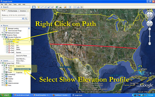
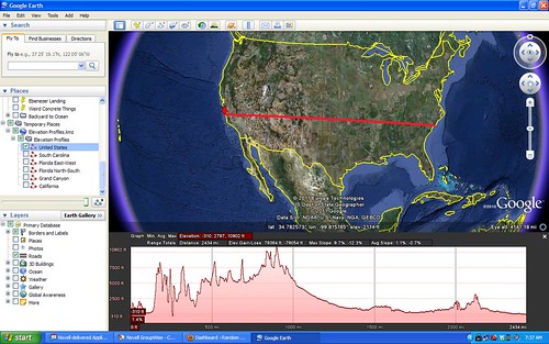
For any given path in Google Earth, you can select Elevation Profile and it will display a graph showing the rise and fall of that path from sea level. This works for ANY path, regardless of length or the number of anchor points. For demonstration sake, though, I like to use a path with only two anchor points – a beginning and and end.

Let’s say, for example, that you create a straight line path across the continental United States. You have two anchor points – one on the west coast, and one on the east coast. Your path would look something like this…

US Selection

Once you have saved that path to My Places, you can right click on the path and select Show Elevation Profile from the menu. That would give you a graph like this…

United States

Read More “Elevation Profiles in Google Earth” »

From Backyard to Ocean

Posted on April 16, 2011 By Tom 11 Comments on From Backyard to Ocean
Geocaching and Maps, Paddling

Backyard2Ocean

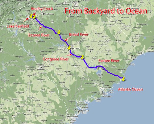
Last night Laura and I were sitting out on our deck look out over the backyard and down to the lake. I wondered what would happen if I were to put my kayak in the water here and paddle it all the way to the ocean. What would I encounter? What rivers would I paddle?

Actually, I’ve got a pretty darn good idea. I’ve paddled and/or explored some sizeable chunks of that route, so I know a bit about it. My paddle route would take this path…

Lake Fairfield –> Brushy Creek –> Enoree River –> Broad River –> Congaree River –> Santee River –> Atlantic Ocean

I’d love to be able to do that whole route without ever having to leave the boat. Unfortunately, there are a few things like shoals, trees, strainers, and a few dams in the way, not to mention Parr Shoals Reservoir and Lake Marion.

Read More “From Backyard to Ocean” »

A Couple of 3D Favorites

Posted on April 14, 2011 By Tom No Comments on A Couple of 3D Favorites
Photography

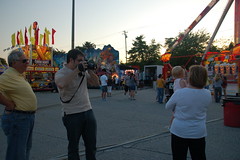
I haven’t been doing much with my binocular camera setup lately.  Quite frankly, I find the dual camera system a bit awkward and clumsy.  There is a little carnival set up at Haywood Mall this weekend, and I’m hoping to take it over there for a few shots of the rides, etc. In the meantime, … Read More “A Couple of 3D Favorites” »

Lowcountry Unfiltered Does Ebenezer Creek

Posted on April 11, 2011 By Tom No Comments on Lowcountry Unfiltered Does Ebenezer Creek
Paddling

LCU on Ebenezer Creek

For our April Second Saturday Lowcountry Unfiltered trip, the group decided to head back to Ebenezer Creek. The last time our group had paddled this tributary of the Savannah River was a snowy February in 2010. I had planned to go on that trip, but a rare snowstorm prevented my joining them. I heard tales and saw photos of a cold snow-covered paddle through beautiful cypress cathedrals. I hated missing the first trip, and was really looking forward to this one.

Ebenezer Creek flows into the Savannah River at Ebenezer Landing, about 10 miles above where I-95 crosses the Savannah. The area is overflowing with history, as the site of one of the earliest settlements in Georgia, and the location of one of the worst betrayals of the Civil War.

Ebenezer Creek GPS Track

Our plan was to put in at Log Landing and paddle down to Ebenezer Landing for a 10.4 mile trip. This added about 3 miles to the group’s previous trip.

Read More “Lowcountry Unfiltered Does Ebenezer Creek” »

Port Wentworth Friday Nights

Posted on April 9, 2011 By Tom 2 Comments on Port Wentworth Friday Nights
Restaurants, Travel, Weirdness

For these lowcountry kayaking trips I often come down on Friday night so that I don’t have to get up so early on Saturday.  Wherever I am I like to find some place quirky and local for dinner, and this trip was no exception.

I checked at the front desk of the motel on I-95, and was informed that there were two good restaurants just up the street.  I scooted round the corner to the first, Silverado’s.

DSCN6955

The van, radio station banner, and balloons should have alerted me to trouble.  I walked in the door and was greeted by a plume of smoke, and a boozy greeting from a woman with stringy hair and fewer teeth than I have.

Well, howdy, you sharp-dressed man, and welcome to Silverado’s!  Have a seat on this here bar stool and buy me a drink!

No, thank you.  I had just driven all the way down straight from the office, and my slacks and white shirt stood out from the jeans and cowboy boots.  I glanced around.  Even if I had wanted to stay, none of the sparse tables between the pool tables and dance floor were available.

I guess the sign advertising Lingerie Lunch today should have also tipped me off.  I’d already missed it, and the smoke was more than I could bear, so I left.  I was after quirky, not hazardous.

Read More “Port Wentworth Friday Nights” »

Jury Duty

Posted on April 8, 2011 By Tom 3 Comments on Jury Duty
Miscellaneous

IMAG0430

A couple of weeks ago this nice little letter from Paul Wickenseimer, Clerk of Court for Greenville County, arrived in my mailbox…

IMAG0431

Yep, a jury summons. I was to start my round of civic duty April 4.  I just completed it, and it was an interesting, yet unfulfilling experience.

Read More “Jury Duty” »

Cool 3D Tools

Posted on April 6, 2011 By Tom No Comments on Cool 3D Tools
Photography

Dogwood Anaglyph

I’ve discovered a treasure trove of 3D tools. Japanese developer Muttyan has put together HUGE collection of applications for viewing and creating stereoscopic images and videos. These include side-by-side stereographs as well as anaglyphs using a variety of color and polarizing schemes.

Screen shot 2011-04-06 at 7.31.06 AM

Online since 2003, the site design looks like it’s stuck in the 1990’s, but the content is current and comprehensive, and that’s what matters.

I first stumbled onto the site looking for a way to create 3D views of Google Earth.  I had wondered if there was a way to create an off-set image that could be converted to anaglyphs.  I found Muttyan’s Stereo Google Earth page, and started exploring.

This page uses two instances of the Google Earth plugin to present side-by-side images of chosen locations.  I started with an overhead screen capture, such as this one of downtown Greenville…

Read More “Cool 3D Tools” »

Greenville Historical Aerial Imagery

Posted on April 5, 2011 By Tom 3 Comments on Greenville Historical Aerial Imagery
History and Genealogy, Internet, Local

Downtown Sanford 1920

Sometime last week the Greenville Cageliner had an article about a new website from the Greenville County GIS Office (http://gis.greenvillesc.gov/historicalimagery/). The website features historical aerial photography imagery as a map, similar to Google Earth. Images are available for 1955, 1965, 1979, 1989, 1997, and 2009, and cover the downtown area, along with a bit of the county. Also included is the Sanford Insurance Map of the city from 1920.

I could spend a HUGE amount of time exploring the site. Looking at how the city has changed over the decades has been fascinating, and somewhat depressing. The patterns of urban sprawl are quite clear at a distance, and it can be sad to look back on landmarks that are no longer there. On the other hand, there have been some marked improvements in areas such as along the banks of the Reedy River, and these images show that very clearly.

I started with the area around the old Furman campus. I had never really understood the location of the old bell tower in relation to the rest of the campus, but this imagery makes it very clear. (Click on the images for a larger view.)

Old Furman Campus 1955

Read More “Greenville Historical Aerial Imagery” »

Eight Years of Blogging

Posted on April 4, 2011 By Tom 1 Comment on Eight Years of Blogging
Miscellaneous

Today marks the eighth year I’ve been blogging in some fashion or other. I never thought I’d keep at it for so long, but here were are in 2011 and I’m still writing. In 2003 blogs were fairly rare, and most people had never even heard the term. I had seen a couple of blogs, … Read More “Eight Years of Blogging” »

Posts pagination

Previous 1 … 118 119 120 … 297 Next

Categories

  • EdTech (197)
  • Entertainment (202)
  • Family (123)
  • Gear (114)
  • General Technology (98)
  • Geocaching and Maps (208)
  • History and Genealogy (275)
  • Internet (142)
  • Local (459)
  • Miscellaneous (560)
  • Music (202)
  • Paddling (268)
  • Photography (781)
  • Podcast (19)
  • Rambling (233)
  • Rants (162)
  • Recipes (37)
  • Religion (48)
  • Restaurants (165)
  • Science (48)
  • Things Overheard (29)
  • Travel (413)
  • Uncategorized (143)
  • Washington Sabbatical (113)
  • Weirdness (61)

Recent Posts

  • Helene One Year Later
  • Once Again, Up the Long Nose
  • Upstate Renaissance Faire
  • Exploring Lake Summit
  • The End of Days

Recent Comments

  • Replying to Moonlight on the Saluda – Daniel Brinneman on Moonlight on the Saluda
  • Tim White on A Feud, a Mule, a Senator, a Potter, and a Ghost Town or Two – Part One
  • Bill Frisbee on In Search of the Road Builder
  • Kristi on From Buzzards Roost to Chappells
  • Gay on In Search of the Road Builder

Tags

blogging cemetery Christmas Columbia Edisto River edtech Entertainment family Flickr Florida Furman Furman University gear Georgia geotagging Ghost Town Ghost Towns Google Earth Google Maps GPS Greenville Greenville Chorale history Instructional Technology kayaking Lake Jocassee LCU Lowcountry Unfiltered maps Music North Carolina Paddling Photography rambling restaurant Restaurants review singing social networking South Carolina time-lapse Travel video Washington Washington State
November 2025
S M T W T F S
 1
2345678
9101112131415
16171819202122
23242526272829
30  
« Sep    

Copyright © 2025 Random Connections.

Theme: Oceanly by ScriptsTown