Skip to content

Random Connections

A collection of photography and exploration focusing on Upstate South Carolina and beyond.

  • Home
  • About Us
  • Photos
  • Resources
  • Other Voices
  • Post Archives
  • Podcast
  • Home
  • Paddling
  • Page 22

Category: Paddling

0

Crowded Cunningham

Posted on August 30, 2010 By Tom No Comments on Crowded Cunningham
Local, Paddling

Traffic Jam

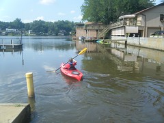
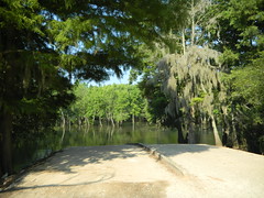
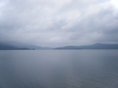
I hadn’t planned to go paddling this weekend. However, someone posted a last-minute trip on the Greenville Canoe and Kayak Meetup group for Lake Cunningham, and I made a last-minute decision to join them.

It turned out to be really last minute, because I overslept, and almost didn’t make it.  Fortunately, Lake Cunningham is close, so I tossed the boat and some gear in the back of the truck and headed out.  I kept it light – one camera, no GPS, and very little extraneous stuff.

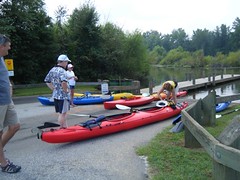
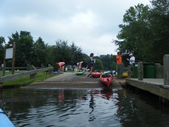
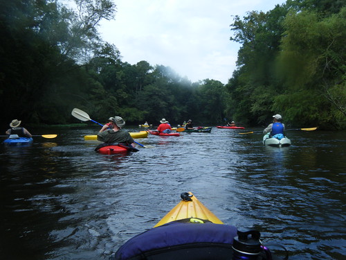
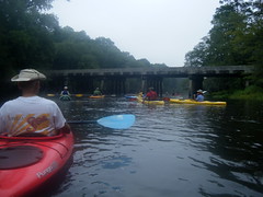
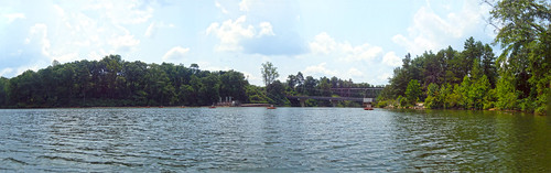
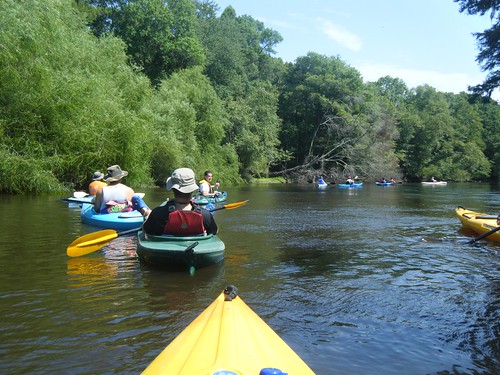
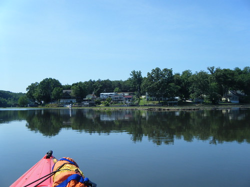
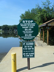
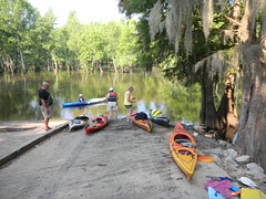
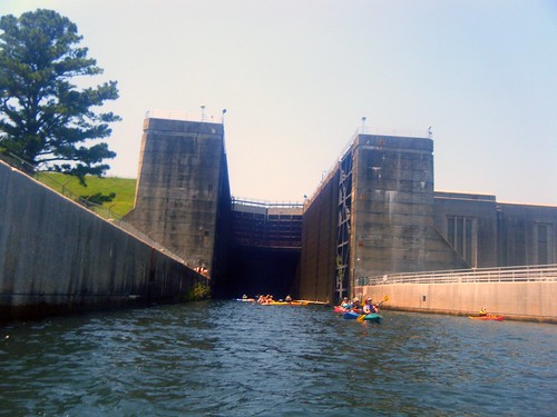
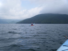
Eventually 20 boaters showed up at the put-in on Lake Cunningham – quite a crowd.  Both skill levels and boat types were quite varied.  There were a couple of us that had paddled the lake extensively, so I wound up as one of the defacto guides for the trip.

Launching at Lake CunninghamGetting Ready to Launch

Read More “Crowded Cunningham” »

Stormy Edisto

Posted on August 17, 2010 By Tom 5 Comments on Stormy Edisto
Paddling

Second Saturday of the month, and once again LowCountry Unfiltered is back on the Edisto. This time we did the section from Stokes Bridge down to Mars Old Field Landing. We had done this one once before, so we were covering somewhat familiar ground. This was by far the largest group we’ve had, with fifteen kayaks on the water.

It had rain most of Friday night. Saturday’s forecast called for a 50% chance of rain. I picked up Bob Donnan and we headed south in the early hours of the morning, with fog followed by cloudy skies once the sun came up. The clouds stayed with us for most of the day.

There was a slight delay as Bob and I went to the take-out instead of the put-in, but soon we rendezvoused with the rest of the group and got launched. Before we even got underway we had one spill, the first of three for the day.

Read More “Stormy Edisto” »

Kayaking around Burrows Bay

Posted on August 5, 2010 By Tom 1 Comment on Kayaking around Burrows Bay
Paddling, Travel

Monday, August 2, 2010

One thing I love about this is the abundance of paddling opportunities. There are flatwater lakes, swift moving rivers, and challenging open water courses. I never get to do as much kayaking as I would like when I’m up here, so this time I decided to make sure I got to paddle at least a little bit. I booked a five-hour tour with Anacortes Kayak Tours before we left South Carolina.

I set out early, planning to catch breakfast in one of my favorite joints in Anacortes before starting the tour. The bay between Samish and Fidalgo Islands was completely fogged in, but it looked like skies would be clearing. When I drove onto Fidalgo, the fog really set in. I found my way to my restaurant and had a fantastic breakfast while also putting out fires at work over the phone. So much for vacation.

I headed on over to the kayak place. I had been another another tour around Hat Island several years ago, but it turns out that it was a different group. This place not only had kayak tours, but also offered whale watching tours.

I was early, and got my instructions to meet the rest of the group on the other side of Fidalgo. Since I had some time, I stopped by Washington Park, which is just past the Anacortes Ferry Terminal. This early the road around the park was closed to auto traffic, so I walked around and took a few shots.

Pretty soon it was time to meet my group, so I headed to the Skyline Marina on Burrows Bay. In addition to myself and the guide, Ken, there were three others – Robbie from Tasmania, and sisters Sue and Carolyn. Robbie and I got single 17 foot Necky Looksha sea kayaks, and the two sisters got a tandem kayak. All of us were experienced kayakers, so Ken gave us some obligatory brief instructions, and we set out across the foggy water.

Our route would take us out around Burrows Island, with a stop at the lighthouse there. We would paddle on around Allan Island, then out to Williamson Rocks if we had time.

Read More “Kayaking around Burrows Bay” »

More Saluda Lake

Posted on July 17, 2010 By Tom 1 Comment on More Saluda Lake
Paddling

Saluda Lake Dam Panorama

Having never been on Saluda Lake before this summer, I’ve now paddled it three times in four weeks.  I’m actually surprised at how it’s become a nice quick paddling destination for when we want to get out on the water.

Friday Alan and I headed out and launched from Saluda Landing at the end of Motor Boat Club Road.  Once again we paid the steep access fee for our two little kayaks.  The more I think about this, the more I realize what a rip-off this is for kayakers.  Motor boats can launch for $8, but kayaks and canoes are $5 each.  A motor boat usually can carry more than one person, so it works out to be a better deal.

Again, we had the annoyance of having to paddle south to avoid the silted-in portion of the lake.  This time, though, we kept paddling south, out toward the main portion of the lake.  This would be new territory for us.

Read More “More Saluda Lake” »

Lazy Saturday on the Edisto

Posted on July 12, 2010 By Tom 4 Comments on Lazy Saturday on the Edisto
Paddling, Photography

Heading down the Edisto

It was a second Saturday, which can only mean one thing – another outing with the guys from Lowcountry Unfiltered. This time our target was once again the Edisto River. This was to be our “beer commercial” float, full of rope swings, mayhem, and general goofing off. And, that pretty much sums up the day.

For this trip we were doing a familiar stretch. The plan was to put in at Mars Old Field Landing, but this time we would paddle past Givhens Ferry State Park and take out at Messervy Landing, adding another three miles to our trek.

Edisto River paddling map - July 10, 2010

Read More “Lazy Saturday on the Edisto” »

Saluda Lake, Take Two

Posted on July 4, 2010 By Tom 1 Comment on Saluda Lake, Take Two
Local, Paddling, Photography

Saluda River

When Alan and I came out to Lake Saluda last week, I wasn’t feeling so hot. Well, actually, I was too hot – heat exhaustion plus a fever of over 100. Couple that with the fact that we missed the channel we were supposed to be taking, and it wasn’t an ideal trip. So, when Dave Freeland called and wanted a close paddling venue that would be good for his 13 year old son, Zach, I suggest heading back to Saluda.

We made our way back down Motor Boat Club Road to Saluda Landing. Personally, I would love to find some other access point. These guys charge per boat, so to launch our three kayaks was $15. I don’t mind paying a parking fee, but the per boat fee is a bit steep. However, they have a monopoly on lake access, and they know it.

Zach and DaveZach Launches

We paddled out, then southward to avoid the silted spit, then turned upstream. This time we hugged the right channel toward the river, rather than being tempted by the more open water of the west arm of the lake.

Read More “Saluda Lake, Take Two” »

Paddling Lake Saluda

Posted on June 26, 2010 By Tom 5 Comments on Paddling Lake Saluda
Paddling, Photography

Saluda Lake Siltation

When I mention Saluda Lake to my acquaintances, many don’t even know it exists. They usually reply, “Don’t you mean the Saluda River?” Or, they try to correct me by naming one of the many other lakes fed by the Saluda. Most don’t seem to be aware that there is a rather large lake on the west side of Greenville with that name.

I can see why Saluda Lake is overlooked. While it’s a nice lake, the banks are almost completely built up, and there is very little public access. There is limited access right at the dam, but no place where one could easily launch a boat. The only boat ramp is on the north end of the lake on Motor Boat Club Road. It’s privately owned, and the signs make you think the owners are somewhat less that friendly.

And we mean it!

Despite the limited access, Alan and I decided to give it a shot. The lake is relatively close, and I’d never been on it. The plan was to put in at the one boat ramp then paddle north up the Saluda River to at least Farr’s Bridge on Highway 183. For a variety of reasons, we didn’t quite make it that far.

Read More “Paddling Lake Saluda” »

Sparkleberry Swamp

Posted on June 15, 2010 By Tom 1 Comment on Sparkleberry Swamp
Paddling, Photography

Sparkleberry Channel

I had been wanting to paddle Sparkleberry Swamp for quite awhile, but always seemed to miss opportunities. I had a solo trip planned for a couple of months ago, but had to cancel when my cat suddenly got ill. I did Jocassee instead. Another trip was planned for a month later, but we canceled because one of our paddlers got ill (we did Jocassee instead.) Several of the Greenville group were staying over after the Pinopolis Lock paddle and heading up on Sunday to paddle Sparkleberry, and this time it didn’t look like anyone was going to get ill, and we were nowhere near Jocassee, so I finally got my chance.

Sparkleberry Swamp, also known as Rimini Swamp, isn’t a natural swamp. It was formed when Lake Marion was created and the forests of the upper Santee River were flooded. Its boundaries are nebulous, depending on water levels and who you ask. Even though it’s not a natural swamp, it has all the characteristics of one. If you picture in your mind what a southern swamp is supposed to be, it probably looks a lot like Sparkleberry.

I spent the night in the town of Santee in a dumpy little motel that deserves its own blog post. Maybe, after therapy, I’ll write that one up. Our group met at the local Bojangles for breakfast, then crossed Lake Marion on I-95, then headed north along the east shore.

This part of the state is about as desolate as it gets. It’s on the lower edge of the Carolina sand hill region, so pine forests and sandy soil are the norm until you reach the actual swamp. We passed through the towns of Summerton and Rimini, which I didn’t even know existed.

When we got to Sparkleberry Landing it was already sweltering. The water was high, and even at the landing the scenery was fantastic. We unloaded the boats and were soon underway.

One of our group of seven had been to the swamp several times before, and served as our guide. It was a good thing. I would have followed the more open channels either north or south, and would have missed the real path through a narrow stand of trees. I was glad I had a functioning GPS and spare batteries.

Read More “Sparkleberry Swamp” »

Paddling the Pinopolis Lock

Posted on June 13, 2010 By Tom 4 Comments on Paddling the Pinopolis Lock
Paddling, Photography

Pinopolis Lock

I had two conflicting paddling opportunities this weekend. My buddies from Lowcountry Unfiltered were going to be paddling the lower Savannah River, and the Greenville Canoe and Kayak group were planning a paddle on Lake Moultrie through the Pinopolis Lock. It was quite the dilemma. Ultimately I decided on the Pinopolis Lock trip because it sounded more like a one-shot deal.

I had seen photos and even a couple of online videos of the Pinopolis Lock. The lock is the highest single-stage lock in the US, and the second-highest in the world. It raises and lowers boats 75 feet from Lake Moultrie to the Tail Race Canal, which then connects to the Cooper River and on to Charleston.

We wouldn’t be paddling quite that far, though. Our plan was to launch from the YMCA beach near the dam, paddle about a mile to our lunch spot, then enter the lock. We would then do a few miles on the canal, then cut back into Wabdoo Creek to our take-out.


View Lake to Lock Paddle in a larger map

Read More “Paddling the Pinopolis Lock” »

Lake Jocassee Waterfalls

Posted on May 23, 2010 By Tom 2 Comments on Lake Jocassee Waterfalls
Paddling, Photography

Dramatic Jocassee

The original plan for today was to paddle Sparkleberry Swamp at the upper end of Lake Marion. However, one of our fellow paddlers fell ill, and he was the one who had suggested the trip. While Sparkleberry would have been great, we used this as an excuse to stay a bit closer home, so Alan and I headed back up to Lake Jocassee.

The weather was not cooperating. I loaded the kayaks into the truck in a light sprinkling of rain, which increased to a downpour just after I got them tied in. It didn’t help that I found a bird’s nest in one of my boats. This is especially weird since I had used that same kayak just two weeks ago. This nest was complete, with broken eggs. Those birds must have been busy. Since the nest looked abandoned and broken I didn’t mind removing it.

It rained on us just a bit more as we drove up to Jocasee, but by the time we got there the rain had ended. There were clouds and fog, but it looked like we would be OK weather-wise.

Read More “Lake Jocassee Waterfalls” »

Posts pagination

Previous 1 … 21 22 23 … 27 Next

Categories

  • EdTech (197)
  • Entertainment (202)
  • Family (123)
  • Gear (114)
  • General Technology (98)
  • Geocaching and Maps (208)
  • History and Genealogy (275)
  • Internet (142)
  • Local (459)
  • Miscellaneous (560)
  • Music (202)
  • Paddling (268)
  • Photography (781)
  • Podcast (19)
  • Rambling (233)
  • Rants (162)
  • Recipes (37)
  • Religion (48)
  • Restaurants (165)
  • Science (48)
  • Things Overheard (29)
  • Travel (413)
  • Uncategorized (143)
  • Washington Sabbatical (113)
  • Weirdness (61)

Recent Posts

  • Helene One Year Later
  • Once Again, Up the Long Nose
  • Upstate Renaissance Faire
  • Exploring Lake Summit
  • The End of Days

Recent Comments

  • Laura Jordan on A Stonecutter’s Tale
  • Tom Nicholson on The Schools of Edgefield and Saluda Counties
  • Replying to Moonlight on the Saluda – Daniel Brinneman on Moonlight on the Saluda
  • Tim White on A Feud, a Mule, a Senator, a Potter, and a Ghost Town or Two – Part One
  • Bill Frisbee on In Search of the Road Builder

Tags

blogging cemetery Christmas Columbia Edisto River edtech Entertainment family Flickr Florida Furman Furman University gear Georgia geotagging Ghost Town Ghost Towns Google Earth Google Maps GPS Greenville Greenville Chorale history Instructional Technology kayaking Lake Jocassee LCU Lowcountry Unfiltered maps Music North Carolina Paddling Photography rambling restaurant Restaurants review singing social networking South Carolina time-lapse Travel video Washington Washington State
November 2025
S M T W T F S
 1
2345678
9101112131415
16171819202122
23242526272829
30  
« Sep    

Copyright © 2025 Random Connections.

Theme: Oceanly by ScriptsTown