Skip to content

Random Connections

A collection of photography and exploration focusing on Upstate South Carolina and beyond.

  • Home
  • About Us
  • Photos
  • Resources
  • Other Voices
  • Post Archives
  • Podcast
  • Home
  • Geocaching and Maps
  • Page 12

Category: Geocaching and Maps

0

Dueling GPSs

Posted on January 4, 2009 By Tom No Comments on Dueling GPSs
Gear, Geocaching and Maps

New GPSs

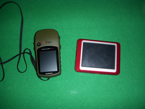
While on our trip to Florida over the holidays my trusty Garmin eTrex Legend GPS unit decided to become less trusty.  I had been having trouble with it prior to the trip.  Any power cable I got for it never seemed to work correctly, and now I was getting weird lines on the display.  It had served me well for five years, but it was now time to replace it.

I had gotten some Best Buy gift cards as well as some cash for Christmas.  I had enough so that I could either get a really nice handheld unit or a really nice unit for my car.  I decided to split the funds and get two GPSs, a handheld Garmin eTrex Venture HC for geocaching, geotagging, and hiking, and a Garmin Nuvi 205 for car navigation.  Here’s a quick review of both units, and my reasons for going this route instead of buying a single higher grade unit.

Read More “Dueling GPSs” »

From Lake Fairfield to Fairfield County

Posted on January 4, 2009 By Tom 1 Comment on From Lake Fairfield to Fairfield County
Geocaching and Maps, History and Genealogy, Photography, Travel

Monticello Store

My last Saturday before heading back to work after Winter Break, and I decided to do some geocaching and photography in Fairfield County.  I had new GPS units to test drive, I had specific locations I wanted to photograph, and I wanted to take some time to swing by my parent’s house.  I had ambitious goals for what I wanted to see and do, perhaps too ambitious.   It turned out to be a day of mixed results – delight and frustration, discovery and missed opportunities.

Read More “From Lake Fairfield to Fairfield County” »

Photo Navigation

Posted on December 3, 2008 By Tom 6 Comments on Photo Navigation
Gear, Geocaching and Maps, Photography

First a caveat – I try not to review or discuss specific gadgets here at RandomConnections unless I actually have the device in hand and have played with it, either having purchased it for myself, for work, or having swiped it from a friend for a test run. I don’t like to speculate on a device’s capabilities unless I’ve seen them myself. Also, especially this close to Christmas a favorable review might be taken as a “wish list”, and that’s not necessarily the case. So, I tend to stick with what I’ve actually seen.

Today I’m going to break with that policy somewhat. My intent was to discuss a capability rather than a specific device or brand, but it turns out that only one brand has this feature (so far.) I’m talking about photo navigation, the ability to navigate to a geotagged photo via GPS as an inherent capability of the device.

Read More “Photo Navigation” »

Secrets Revealed in ArcGIS Explorer

Posted on October 2, 2008 By Tom 8 Comments on Secrets Revealed in ArcGIS Explorer
Geocaching and Maps

ArcGIS-Explore-Screen-Captu

LongArcGIS-Explore-Screen-Captu

Long before Google Earth came on the scene there was ArcGIS from ESRI. There are two (actually, multiple) flavors of this. There were the professional GIS versions consisting of ArcMAP and ArcServer, and a free viewer, ArcExplorer. I attended a couple of workshops on ArcExplorer, was impressed by its potential for the classroom, but never really got into it. Along came Terraserver making free satellite imagery available, then Google Earth took the world by storm, somewhat obscuring these previous free mapping services.

While working on another project I needed to check out ArcGIS Explorer once again, and was surprised to find that it now looks very much like Google Earth with a similar user interface. Navigation is essentially the same – you can zoom in, tilt, and pan just like in GE. There are search functions and you and create placemarks. While Explorer will open KML files, it’s designed to be more compatible with ArcGIS data.

Google Earth has a much larger user-contributed base. However, there is much more accurate GIS data available for Explorer from various GIS organizations around the world. When comparing the free versions of these programs, you could think of Google Earth as being more populist, and ArcGIS Explorer as more professional.

Read More “Secrets Revealed in ArcGIS Explorer” »

Two Quick Earthly Diversions

Posted on July 1, 2008 By Tom No Comments on Two Quick Earthly Diversions
Geocaching and Maps

Here are two quick video links that I found while browsing my RSS feeds this morning. Oddly enough, both are hosted on Vimeo.com, but I found them linked from different sources. First is the video “Where the Hell is Matt?” found link in an article on BoingBoing.net. Matt is a 31 year old slacker who … Read More “Two Quick Earthly Diversions” »

Paddling Resume’

Posted on June 26, 2008 By Tom No Comments on Paddling Resume’
Geocaching and Maps, Paddling, Uncategorized

Tom Kayak OOB

In case you haven’t noticed, I love to paddle. My preference is for moving water, but a nice flatwater paddle on a river or lake can be fun, too. I started this obsession when I was about fifteen, running the Enoree River with my high school buddies in an army surplus inflatable raft that had more patches than original material. College years were more adventurous trips in large whitewater rafts, or lazy floats in inner tubes. When I started teaching I could afford a cheap Coleman canoe (which I still have), and now I paddle a Perception Torrent sit-in-top whitewater kayak. This being said, I have now put together my paddling resume’ in Google Earth KMZ format.

Read More “Paddling Resume’” »

Greenville in Street View!

Posted on June 11, 2008 By Tom 1 Comment on Greenville in Street View!
Geocaching and Maps

Much of the Upstate, including Greenville, is now available in Google Street View. Last night I discovered that Columbia and Charlotte had been added, and this morning Greenville was also on the list. The blue areas in the map below show the current coverage: In Google Earth, the coverage is a bit deceptive. There are … Read More “Greenville in Street View!” »

The Travels of JH, Junior

Posted on May 30, 2008 By Tom 4 Comments on The Travels of JH, Junior
Geocaching and Maps

In the summer of 2006 we made a trip to London and visited the Royal Observatory in Greenwich. While there I picked up a fuzzy little souvenir I intended to use as a Travel Bug for geocaching. Thus was born “JH, Junior.” JH, Junior. was named for John Harrison (1693-1776). Harrison was an English clockmaker … Read More “The Travels of JH, Junior” »

Embeddable Google Earth

Posted on May 29, 2008 By Tom No Comments on Embeddable Google Earth
Geocaching and Maps

The functionality of Google Earth is showing up in more and more places outside of the actual Google Earth software. Much of what you could do in GE is now available in Google Maps. Maps has had the ability to read KML/KMZ files for awhile now, and for the most part the imagery is the same for both systems. Well the folks at Google have blurred the line even more with the recent release of the Google Earth COM API.

The new API allows developers to create interfaces to the Google Earth data. Probably one of the best examples of this has been done by the folks at TakItWithMe.com. They have created a version of Google Earth than can be embedded into blog posts, web pages, etc.

In order to take advantage of this three things have got to be in place:

  1. Google Earth 4.x or higher must be installed on your computer.
  2. You have to install the Google Earth 3D plugin for the browser you plan to use.
  3. The KML/KMZ file you plan to use must be available online, either on hosted webspace or on the user’s My Maps folder in Google Maps.

If you have at least the first two of these already in place on your computer, you can click the link below to read more, and you’ll see a demonstration…

Read More “Embeddable Google Earth” »

Memorial Day Caching

Posted on May 26, 2008 By Tom 1 Comment on Memorial Day Caching
Geocaching and Maps

Today I went geocaching with John Kaup and his son, Richard. I’ve found that I enjoy geocaching with others more than just heading out on my own. I think that’s why I haven’t been very active lately – it’s been harder to coordinate times with friends who are interested. John and I were actually written … Read More “Memorial Day Caching” »

Posts pagination

Previous 1 … 11 12 13 … 21 Next

Categories

  • EdTech (197)
  • Entertainment (202)
  • Family (124)
  • Gear (114)
  • General Technology (98)
  • Geocaching and Maps (208)
  • History and Genealogy (276)
  • Internet (142)
  • Local (459)
  • Miscellaneous (561)
  • Music (202)
  • Paddling (268)
  • Photography (782)
  • Podcast (21)
  • Rambling (234)
  • Rants (162)
  • Recipes (37)
  • Religion (48)
  • Restaurants (165)
  • Science (48)
  • Things Overheard (29)
  • Travel (413)
  • Uncategorized (144)
  • Washington Sabbatical (113)
  • Weirdness (61)

Recent Posts

  • A Trip to Lando
  • Carolina Ghost Towns – Fort Motte, South Carolina
  • Carolina Ghost Towns Season 3 Trailer
  • Thanksgiving at Home
  • Home!

Recent Comments

  • Virginia Pepper on A Trip to Lando
  • julie niemeyer on Perryville Pickin’ and Grinnin’
  • Heath H Cowart on The Haunting of Farr’s Bridge
  • Sheryl Gunter Bingham on Chasing the Swamp Rabbit – Part 3, Sievern and Edisto Academy
  • Jerome A Mann on Update on Ghost Town Research

Tags

blogging cemetery Christmas Columbia Edisto River edtech Entertainment family Flickr Florida Furman Furman University gear Georgia geotagging Ghost Town Ghost Towns Google Earth Google Maps GPS Greenville Greenville Chorale history Instructional Technology kayaking Lake Jocassee LCU Lowcountry Unfiltered maps Music North Carolina Paddling Photography rambling restaurant Restaurants review singing social networking South Carolina time-lapse Travel video Washington Washington State
January 2026
S M T W T F S
 123
45678910
11121314151617
18192021222324
25262728293031
« Dec    

Copyright © 2026 Random Connections.

Theme: Oceanly by ScriptsTown