Skip to content

Random Connections

A collection of photography and exploration focusing on Upstate South Carolina and beyond.

  • Home
  • About Us
  • Photos
  • Resources
  • Other Voices
  • Post Archives
  • Home
  • Geocaching and Maps
  • Greenville in Street View!

Greenville in Street View!

Posted on June 11, 2008 By Tom 1 Comment on Greenville in Street View!
Geocaching and Maps

Much of the Upstate, including Greenville, is now available in Google Street View. Last night I discovered that Columbia and Charlotte had been added, and this morning Greenville was also on the list. The blue areas in the map below show the current coverage:

SC-Street-View-Coverage

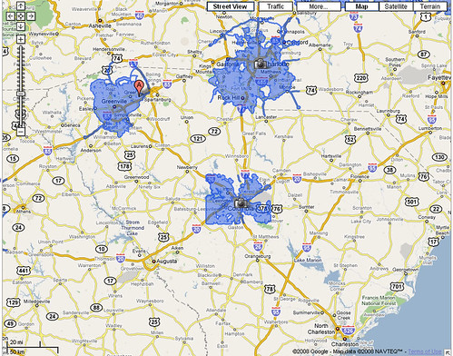
In Google Earth, the coverage is a bit deceptive. There are camera icons for Spartanburg and Anderson, but it is really only those areas in terms of spreading out from Greenville. So, for example, the Duncan, Lyman, Wellford areas are on the very eastern edge of the Greenville coverage. Since they are in Spartanburg County, Spartanburg gets a camera icon.

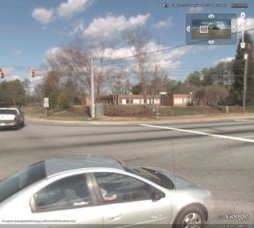
Of course, the first thing I had to do was find our house and my office:

My-House-Street-View

District Office Street View

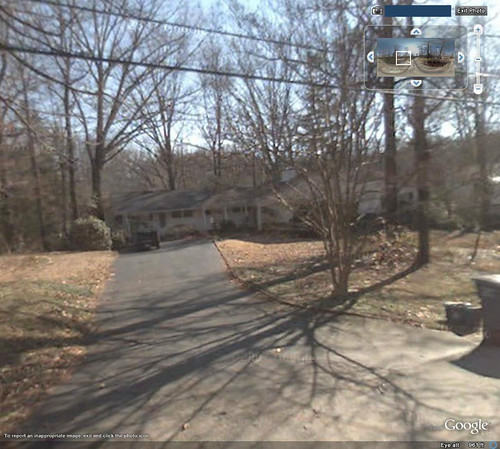
I did blank our our address on my house image.

It looks like these images were taken sometime last winter, probably in the January-February time frame. The new cul-de-sac at the end of our street has been completed, and our new neighbors across the street have one of those P.O.D.S. in their front yard. Since my garbage and recycling are out front and since only my truck is in the yard, this was probably taken on a Friday. I was able to find images from one of our new schools currently under construction, and it looks like it’s fairly far along.

It’s interesting to see which areas are covered and which are not. For example, downtown Spartanburg isn’t covered, but downtown Campobello is. It looks like the Google van took a road trip up along Highway 414 over to Landrum, then down I-26, but not many roads in-between. Speaking of the van, you can see its shadow in several views. The Immersive Media camera is clearly visible on a pole atop the car in the shadow.

While I’ve enjoyed visiting new places in Street View, visiting places that I know very well is equally interesting. Oddly enough, none of the coastal areas are currently covered. Charleston, Myrtle Beach, and Hilton Head – the more touristy areas – haven’t been visited by Google. I’m sure that’s just a matter of time.

[tags]Google Maps, Google Earth, Street View[/tags]

Tags: Google Earth Google Maps Street View

Post navigation

❮ Previous Post: A World of 3D Photography
Next Post: Father’s Day Rambles ❯

One thought on “Greenville in Street View!”

  1. DuckHunter says:
    June 17, 2008 at 8:45 pm

    Thanks to this post, I just used up another hour of my life. Still not far enough to reach my house, but closer.

    Reply

Leave a Reply Cancel reply

Your email address will not be published. Required fields are marked *

This site uses Akismet to reduce spam. Learn how your comment data is processed.

Categories

  • EdTech (200)
  • Entertainment (202)
  • Family (121)
  • Gear (115)
  • General Technology (99)
  • Geocaching and Maps (208)
  • History and Genealogy (266)
  • Internet (144)
  • Local (452)
  • Miscellaneous (550)
  • Music (197)
  • Paddling (251)
  • Photography (780)
  • Podcast (6)
  • Rambling (227)
  • Rants (161)
  • Recipes (34)
  • Religion (48)
  • Restaurants (165)
  • Science (48)
  • Things Overheard (29)
  • Travel (412)
  • Uncategorized (129)
  • Washington Sabbatical (113)
  • Weirdness (60)

Recent Posts

  • Washington Music Round-Up
  • Landsford Canal Lilies and the Catawba River
  • Paddling Up the Long Nose
  • A Bates Old River Two-fer
  • In Search of the Road Builder

Recent Comments

  • Kathy Jewell on Even More Echo Valley
  • Alan on Landsford Canal Lilies and the Catawba River
  • John Dorroh on A Long Wet Hike on Long Cane Creek
  • John Dorroh on A Long Wet Hike on Long Cane Creek
  • Emily on Paddling Up the Long Nose

Tags

blogging cemetery Christmas Columbia Edisto River edtech Entertainment family Flickr Florida Furman Furman University gear Georgia geotagging Ghost Town Ghost Towns Google Earth Google Maps GPS Greenville Greenville Chorale history Instructional Technology kayaking Lake Jocassee LCU Lowcountry Unfiltered maps Music North Carolina Paddling Photography rambling restaurant Restaurants review singing social networking South Carolina time-lapse Travel video Washington Washington State
June 2023
S M T W T F S
 123
45678910
11121314151617
18192021222324
252627282930  
« May    

Copyright © 2023 Random Connections.

Theme: Oceanly by ScriptsTown