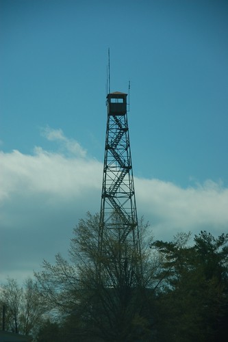
It seems like spring break got away from me without my being about to get out and visit the lookout towers like I wanted. This Friday was one of the best days, as far as weather was concerned, so I was able to visit some of the locations. My target would be those towers located in Northwestern South Carolina, along with any other interested tidbits I might discover along the way. It was a push, but I managed to visit eight tower locations in one day.
Category: Local
Local items of interest from Greenville and Upstate SC.
While out driving the rural highways of South Carolina you may have come across a road sign with this symbol… Seeing a road sign like this lets you know that you are on either the South Carolina Discovery Route, or the South Carolina Nature Route, both parts of the South Carolina Heritage Corridor. On the … Read More “South Carolina Heritage Corridor” »
I was reading my friend Duckhunter’s blog about his discovery of a house with “Haint Blue” paint on the porch. Duck does a great job of describing this practice, but it got me thinking about other, similar superstitions. In particular, I wondered if there were other superstitions like this, perhaps some even specific to the … Read More “Very Superstitious” »
The above photo is of a house near my office. It’s a bit blurry because I shot quickly as I was driving past. What caught my attention was the prominent initial “F” worked into the chimney masonry. In a post-mortgage fallout, post-“Flip this House” era, the idea of marking one’s house so indelibly seems quaint, almost laughable.
This is a very permanent mark. In many cases tan colored bricks are built into the chimney structure. Just about the only way to remove the initial is to tear down and rebuilt the chimney. Painting over it only partially obscures the letter, as the bricks that make up the initial are often of a different shape or orientation, so you can still see the outline.
The photo above is a panorama of the Liberty Bridge, Falls Park, and Reedy Falls area in downtown Greenville. It consists of five images taken at a wide angle 18mm focal length, then stitched together in Photoshop. It turned out to be quite a learning process and experiment in adaptation.
The first thing I tried was to load up all five shots and try to use the automatic panorama tool in Photoshop. Some of the buildings were completely obliterated, and it simply rejected one image that it couldn’t get to fit. I’m still using version CS2 of Photoshop, so there may have been improvements in the automated tool, but the results with my version were disappointing. It was time to go to manual mode.
The problem with using wide-angle shots is that you get some unusual perspective distortion at the edges. If you look at each photo individually, each looks OK.
Thursday evening I met up with several of my Flickr photographer friends for a photo walk. Tracy (Wilhemina Lump Lump), Eric (RestedTraveler), and James (James Wellman) and I gathered at the entrance to Falls Park for a downtown expedition. It turned out to be a great gathering, and we really learned quite a bit from each other about various photographic techniques.
When we first planned this outing we had scheduled it for a couple of weeks ago, right as the snow storm hit. The intent was to go out and try to do some long exposure photography. When we reschedule, we failed to take into account the time change, so we still had more daylight than we had planned. Oops.
Driving around town the past week or so I had been scouting for locations where I could get good shots of traffic trails. I wanted to avoid the Overbrook Overpass, where it seems everyone takes a photo, so something different was needed. Since I’d had dinner at The Clock, I decided to look for some … Read More “Traffic Trails Around Town” »
As long as I’ve lived in this area I can’t ever remember eating at The Clock on Wade Hampton. Tonight I was on my own for dinner, and I had some ideas for photography in the area, so I decided to give it a try. Background Located at the corner of Wade Hampton and Pleasantburg … Read More “The Clock on Wade Hampton” »
Well, it looks like my exuberance was premature. I was able to find some additional information on the Internet which lists this bridge as being of fairly modern construction.
Dale. J. Travis operates a website devoted to round barns and covered bridges, both fascinating structures. He has a comprehensive listing from across the US, not just of historic structures but of modern construction as well. Travis lists thirteen bridges for South Carolina, including Campbell’s and this one on Mayfield Road. Most of these are decorative, and are found on golf courses and gardens.
According to Travis’ information, the Mayfield Bridge was built in 1991 and is about 25 feet in length. I’m guessing that it hasn’t been kept up since that time, so the tin roof has rusted, making it look older than it is.
Which brings me to the statement the man on the side of the road gave me. The only thing I can think is that he was referring to the actual roadway bridge. Who knows? Then again, maybe Mr. Travis has incorrect information. However, with every reputable reference saying that Campbell’s is “the last”, it’s hard to refute the evidence that this isn’t an authentic structure.
According to South Carolina: A Day at a Time, Campbell’s Covered Bridge is “the only covered bridge still standing in South Carolina.” My friend Duckhunter pointed me toward DiscoverSouthCarolina.com which says that Campbell’s “is South Carolina’s only remaining covered bridge.” Several other websites repeat this sentiment. So, imagine my surprise when I found this just … Read More “The Bridges of Spartanburg County” »


