Skip to content

Random Connections

A collection of photography and exploration focusing on Upstate South Carolina and beyond.

  • Home
  • About Us
  • Photos
  • Resources
  • Other Voices
  • Post Archives
  • Podcast
  • Home
  • Local
  • Traffic Trails Around Town

Traffic Trails Around Town

Posted on February 26, 2009 By Tom 1 Comment on Traffic Trails Around Town
Local, Photography

I-385 Light Trails

Driving around town the past week or so I had been scouting for locations where I could get good shots of traffic trails. I wanted to avoid the Overbrook Overpass, where it seems everyone takes a photo, so something different was needed.

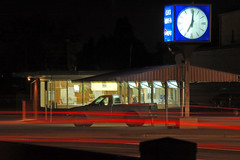
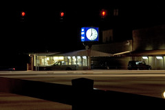
Since I’d had dinner at The Clock, I decided to look for some spots in the Wade Hampton/Pleasantburg area. I was hoping to take advantage of the “blue hour” – that time right after sunset when long exposure shots bring out a beautiful deep blue shade to the sky. Of course, skies were overcast, so I had to be content with the trails themselves.

My first target had long caught my eye. Over Pleasantburg Drive Bob Jones University has constructed a pedestrian walkway for its students. Because it’s such an imposing steel structure, and given BJU’s historic reputation (whether accurate or not), we had nicknamed it “Stalag Bob Jones”. Both ends of the structure are on publicly accessible sidewalks, so it looked like a great spot for a shot down the center of the road.

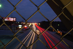
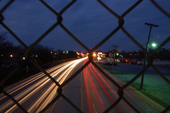
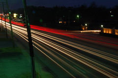
As you can see, the opportunities for traffic trails in both directions was excellent, but a chain link fence obscures the view. I was able to get unobstructed shots from the top landing of the staircase – off to the side, but still acceptable.

From here I drove back around the corner to The Clock. More specifically, I drove into Woodland Memorial Park Cemetery. The cemetery level is about ten feet above the street level, so there are good views of the intersection of Wade Hampton Blvd and Pleasantburg Drive. Since this is right across from The Clock, I tried to included it in the shots.

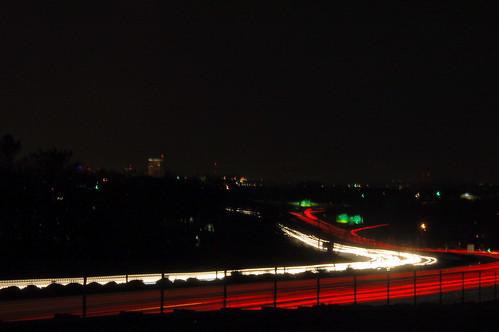
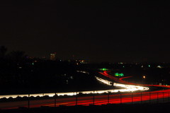
It was time to check out a couple of the interstate locations I had wanted to shoot. I drove around to Pelham Road, then took Villa Road, which runs right next to I-385. At one point the road widens where a lot is cleared for construction. This location had views of the downtown buildings in the distance as well as the Interstate. It worked OK, but there was more traffic on Villa Road than I had anticipated.

Those were the only places I actually took photos. On Independence Blvd near Roper Mountain there are some parking lots that might have views of I-385 and I-85. The Roper Mountain Road overpass provides some views of I-85, but none of these really caught my eye. Still, I think I found some good locations. Next time, I think I’ll try to find some spots downtown.


View Larger Map

Tags: long exposure Photography traffic trails

Post navigation

❮ Previous Post: The Clock on Wade Hampton
Next Post: Super Simple Time Lapse ❯

One thought on “Traffic Trails Around Town”

  1. Melbrooke says:
    February 26, 2009 at 9:47 am

    Those photos are beautiful!! Good eye…

    Reply

Leave a Reply Cancel reply

Your email address will not be published. Required fields are marked *

This site uses Akismet to reduce spam. Learn how your comment data is processed.

Categories

  • EdTech (197)
  • Entertainment (201)
  • Family (123)
  • Gear (114)
  • General Technology (98)
  • Geocaching and Maps (208)
  • History and Genealogy (275)
  • Internet (141)
  • Local (458)
  • Miscellaneous (557)
  • Music (202)
  • Paddling (264)
  • Photography (781)
  • Podcast (15)
  • Rambling (233)
  • Rants (161)
  • Recipes (36)
  • Religion (48)
  • Restaurants (165)
  • Science (48)
  • Things Overheard (29)
  • Travel (413)
  • Uncategorized (142)
  • Washington Sabbatical (113)
  • Weirdness (59)

Recent Posts

  • Six Layer Bourbon Grits Bowl
  • How’s the House? Part 2
  • Carolina Ghost Towns – Merrittsville
  • Gimme Shelter
  • From Kingsbury to Stoneboro – Rambling in Lancaster County

Recent Comments

  • Curtis V Fink on Chasing the Swamp Rabbit – Part 3, Sievern and Edisto Academy
  • Bobby Stan Gillespie on Exploring Jacks Township
  • Richard Thornton on Paddling Up the Long Nose
  • John Guerrant on From Kingsbury to Stoneboro – Rambling in Lancaster County
  • John Guerrant on Gimme Shelter

Tags

blogging cemetery Christmas Columbia Edisto River edtech Entertainment family Flickr Florida Furman Furman University gear Georgia geotagging Ghost Town Ghost Towns Google Earth Google Maps GPS Greenville Greenville Chorale history Instructional Technology kayaking Lake Jocassee LCU Lowcountry Unfiltered maps Music North Carolina Paddling Photography rambling restaurant Restaurants review singing social networking South Carolina time-lapse Travel video Washington Washington State
May 2025
S M T W T F S
 123
45678910
11121314151617
18192021222324
25262728293031
« Apr    

Copyright © 2025 Random Connections.

Theme: Oceanly by ScriptsTown