Skip to content

Random Connections

A collection of photography and exploration focusing on Upstate South Carolina and beyond.

  • Home
  • About Us
  • Photos
  • Resources
  • Other Voices
  • Post Archives
  • Podcast
  • Home
  • 2012
  • June
  • 26

Day: June 26, 2012

If you build a dam here…

Posted on June 26, 2012 By Tom 5 Comments on If you build a dam here…
EdTech, Geocaching and Maps

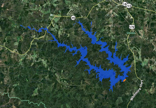
Lake Union 1

While kayaking on Parr Shoals Reservoir last Saturday, Alan and I started discussing lakes in general. Specifically we were talking about the placement of dams and the hydrology of water backing up to fill in the space. We laughed at one of the last scenes of “O Brother, Where Art Thou“, where the lake comes flooding in as a torrent, rather than rising gently as it should. As far as movies go, “Deliverance” was a more realistic view of how lakes are created.

As the conversation proceeded, I reminisced about the time I participated in the SC-MAPS project when I was a teacher. This was a three-day workshop where we learned how to use topographic maps and satellite imagery in the classroom. This was long before the days of Google Earth, so the ability to look at overhead images of where you live was still a novelty.

One of the activities they had us do was to draw a line across a river connecting contour lines at the same height. This line would represent a dam. Then we were to trace the contour line at that level all the way around, outlining the area that would be inundated by the new lake. It was a tedious process, but the results were fascinating. The lakes always turned out much larger than we expected.

As Alan and I talked, we wondered if there was some automated way to do this using Google Earth, so when I got home I started searching for a method. The automated systems I found were complex, requiring advanced knowledge of ArcGIS, hydrology, and GIS techniques in general. Even so, I think I’ve found a simple way in Google Earth. Here’s how…
Read More “If you build a dam here…” »

Rambling through Greenwood

Posted on June 26, 2012 By Tom 1 Comment on Rambling through Greenwood
Photography, Rambling

Dino Cafe Sign

I got a note from fellow explorer Mark Elbrecht the other day mentioning that they were offering tours of Cokesbury College as part of Greenwood’s Festival of Flowers. Mark was able to do the tour on Saturday, but I was off paddling Parr Shoals. My brother Houston was in town, so we stopped by to pick up my sister Glynda and headed down toward Greenwood.

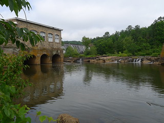
The route from Gray Court to Greenwood cuts across the Laurens County countryside. Southwest of Hickory Tavern we found ourselves at Boyds Mill Pond, an impoundment on the Reed River with a small hydroelectric plant. We stopped to take a few photos.

Boyds Mill Pond Jun 24, 2012 11-039Boyds Mill Pond Jun 24, 2012 11-036

The river below the dam has several fishing access spots. One point looked like it would be an excellent place to launch a kayak, but it was very trashy. There were several folks fly-fishing downstream.

Read More “Rambling through Greenwood” »

Categories

  • EdTech (197)
  • Entertainment (201)
  • Family (123)
  • Gear (114)
  • General Technology (98)
  • Geocaching and Maps (208)
  • History and Genealogy (275)
  • Internet (141)
  • Local (458)
  • Miscellaneous (557)
  • Music (202)
  • Paddling (265)
  • Photography (781)
  • Podcast (17)
  • Rambling (233)
  • Rants (161)
  • Recipes (36)
  • Religion (48)
  • Restaurants (165)
  • Science (48)
  • Things Overheard (29)
  • Travel (413)
  • Uncategorized (143)
  • Washington Sabbatical (113)
  • Weirdness (59)

Recent Posts

  • Carolina Ghost Towns – Mitchellville
  • Carolina Ghost Towns – Paper Towns
  • Kayaking on Wolf Creek Lake
  • Carolina Ghost Towns – Colonial Dorchester
  • Six Layer Bourbon Grits Bowl

Recent Comments

  • Eric Kincaid on Kayaking and Coffee
  • Daniel S Mawn on Remembering the Walke
  • Judy Hall on The Clock on Wade Hampton
  • Charles Johnson on In Search of the Road Builder
  • Anthony h hannig on From Kingsbury to Stoneboro – Rambling in Lancaster County

Tags

blogging cemetery Christmas Columbia Edisto River edtech Entertainment family Flickr Florida Furman Furman University gear Georgia geotagging Ghost Town Ghost Towns Google Earth Google Maps GPS Greenville Greenville Chorale history Instructional Technology kayaking Lake Jocassee LCU Lowcountry Unfiltered maps Music North Carolina Paddling Photography rambling restaurant Restaurants review singing social networking South Carolina time-lapse Travel video Washington Washington State
June 2012
S M T W T F S
 12
3456789
10111213141516
17181920212223
24252627282930
« May   Jul »

Copyright © 2025 Random Connections.

Theme: Oceanly by ScriptsTown