Skip to content

Random Connections

A collection of photography and exploration focusing on Upstate South Carolina and beyond.

  • Home
  • About Us
  • Photos
  • Resources
  • Other Voices
  • Post Archives
  • Podcast
  • Home
  • 2010
  • April

Month: April 2010

Google Earth Meets Google Maps

Posted on April 28, 2010 By Tom No Comments on Google Earth Meets Google Maps
Geocaching and Maps

Google Earth is now accessible through a browser via the Google Maps page.  The plug-in for Google Earth has been available for quite some time now, so this is only a natural progression.  On the Maps page there is now an “Earth” view in addition to Map and Satellite.  Terrain has been relegated to the … Read More “Google Earth Meets Google Maps” »

Adding Google Earth to PowerPoint – Another Method

Posted on April 26, 2010 By Tom 3 Comments on Adding Google Earth to PowerPoint – Another Method
Geocaching and Maps

Google Earth

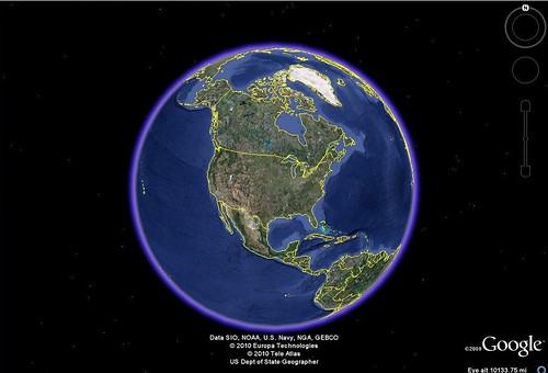
I recently received a request for help from one of my readers regarding Google Earth and PowerPoint.  The reader wanted to know how to put a Google Earth tour into PowerPoint.  This website gets lots of hits from folks wanting to learn how to embed Google Earth into their presentations, but Google hasn’t made it easy.  Therefore, I’ve put together a tutorial for one method, but first it might be helpful to clear up a few things.

  1. Google Earth Tours – Yes, you can create and save tours.  However, the files that are created are KMZ files that can only be opened in Google Earth.  These are NOT video files, and they cannot be easily imported into another program.
  2. Embedding Google Earth – Right now there is no good way to get Google Earth to play in a PowerPoint slide.  You could create a link on your slide that opens a KMZ file outside of PowerPoint in Google Earth itself.  You could also embed a web page that has the Google Earth plug-in for web enabled, but that get’s to be more complicated than it’s worth.

I’ve already demonstrated how it’s possible to add PowerPoint slides to Google Earth.  However, I still get inquiries for the other way around – adding Google Earth to PowerPoint, even though the two points above make it difficult, if not impossible.   Well, there are a couple of ways, but they’re not perfect.  The first involves just exporting static images from Google Earth and putting those images into your slides.  The other involves video screen capture.  Here’s how it’s done…

Read More “Adding Google Earth to PowerPoint – Another Method” »

I’m Sorry, I’ll Read That Again

Posted on April 23, 2010 By Tom 1 Comment on I’m Sorry, I’ll Read That Again
Entertainment

Before Monty Python brought his (in)famous Flying Circus to British TV and film, there was a BBC radio show entitled “I’m Sorry, I’ll Read That Again” (ISIRTA). The show was pure silliness, and starred David Hatch as the hapless announcer, and also featured voices of John Cleese, Graeme Garden, Tim Brooke-Taylor, Jo Kendall, and Bill … Read More “I’m Sorry, I’ll Read That Again” »

Return to Long Branch

Posted on April 18, 2010 By Tom 7 Comments on Return to Long Branch
History and Genealogy, Religion

Long Branch Pentecostal Holiness Church

Long Branch Pentecostal Holiness Church…

The name is long in our family lore. The church was established by my grandfather in 1911, as were many of the Pentecostal Holiness churches of this area. My father pastored the church for most of the 1960’s, and it is here that I have my earliest memories of church.

The church was small, and our large family made up a sizable bit of the congregation. My father preached and led the singing, and my mother played the piano after Mrs. Annabelle Brown left that position. It was just a tiny, unique country church, but its effect on us was indelible. The place is etched in our memories, and the myths and legends of Long Branch have grown over time, and have been embellished through retelling. So, today, nearly forty years since I last set foot in the church, I decided to see how close those myths were to today’s reality.

Read More “Return to Long Branch” »

Lake Jocassee Morning Paddle

Posted on April 18, 2010 By Tom 1 Comment on Lake Jocassee Morning Paddle
Paddling, Photography

Lake Jocassee

The weekend didn’t turn out exactly as I had planned. I had a meeting in Columbia on Friday, so Thursday night I loaded up the boat on top of my car. The plan was to drive down for the meeting, then continue southward to Lake Marion and Sparkleberry Swamp.  Unfortunately, our cat Percy decided to get his paw hurt, so I had to drive back from my meeting earlier than expected to get him to the vet.  He’s OK – just a small cut and possible sprain, but nothing broken.

I really didn’t want to drive back down I-26 again, but I still had the kayak on top of the car and still wanted to go paddling somewhere.  All of my paddling partners were otherwise occupied, so I was on my own.  I finally decided on Lake Jocassee as a reasonable target.

Last time I was here I had just gotten my Old Town Dirigo, and was wanting to see as many waterfalls as I could.  This time I had the Pungo, but wasn’t really sure where I wanted to paddle.  There was one waterfall from the last trip that I didn’t get to see because some bozo parked a pontoon boat right in front of it and showed no signs of moving.  I decided to make that my first target. From there I wasn’t sure where I’d wind up.

The air temperatures were OK, but the water was quite chilly as I unloaded the boat and got set to head out.  There was a little activity at the boat ramp, but nowhere near as much as my last visit.  A boy and his son were taking a canoe out, and one pontoon boat launched.  Another trio was spending lots of time fussing over a tandem rec boat.  I talked with them, and one man and his brother were planning to paddle the entire length of the Savannah River, but not all at once.  On today’s trip they were heading up to the North Carolina River.  I hated to tell them that they weren’t on the Savannah, and wouldn’t be for quite awhile.  However, I’m sure they knew that.

Read More “Lake Jocassee Morning Paddle” »

Hans and Franz

Posted on April 16, 2010 By Tom 5 Comments on Hans and Franz
Restaurants

0415001826

One of my paddling buddies accused me of posting “food porn.” Sorry, James, but here’s some more…

For months now I’ve seen signs for Doner Kabob, and have wondered about the food being advertised. To me, a kabob is meat on a stick with vegetables, cooked on a grill.  Little did I know that it’s actually a type of German sandwich, in this case sold from a large trailer that moves from place to place.

One of our office co-workers offered to get sandwiches for everyone at lunch, and they were quite good.  Mine was a very spicy turkey on a flat sort of bun.  Along with the discovery of the sandwich came the discovery of a new German restaurant in the community of Pelham.  So, with Laura out of town, tonight was the perfect night for my sister Glynda and I to give Hans and Franz a try.

Background

First, the building – this was one of the original 1860’s buildings for the Pelham Mills.  It was a barn structure to support the main mill, which made Confederate uniforms during that war.  For awhile recently Rocky Creek Bakery occupied the building.  Glynda and I had a couple of lunches here, and loved the old structure and wonderful bread.  We were both thrilled to see the new restaurant here.

It’s my understanding that Hans and Franz is an enterprise by the folks that own Addy’s Dutch Restaurant in downtown Greenville.  They have been wanting to branch out into German cuisine, which has been sorely lacking in the area since the demise of Haus Edleweiss.  While not owned by them, the Doner Kabob trailer works in partnership with the restaurant in a symbiotic relationship.

Read More “Hans and Franz” »

Edistoing Perfection

Posted on April 11, 2010 By Tom 1 Comment on Edistoing Perfection
Paddling, Photography

Edisto Skies

Edistoing (verb) – kayaking down the river, fun, rope swings, lots of fun, owls, loads of fun, funny side up, fossils, funtatious, sun burn, funtastic,endless oxbows, a heapin good time of fun, firecrackers, funsational, swimming with the gators, having fun, cypress knees, funasoric, beer, too much fun, and the Lowcountry Unfiltered Guys. (reference, John Ring)

Edisto (noun) – a state of blissful near-perfection brought on by the act of Edistoing; also the name of a blackwater river in the lowcountry of South Carolina.

I had my choice of paddling venues today. I could have joined the throngs in Spartanburg County for the Tame the Tyger river race, or I could join the Lowcountry Unfiltered gang for another trek on the Edisto River. I chose the latter. It turned out to be of paddling nirvana, with incredibly blue skies, cypress cathedrals, and camaraderie all around.

I got up early Saturday morning and drove down to Clinton to pick up Bob Donnan.  By 6:30 we were on our way to the river.  I set up my Nikon S50 on the dashboard and had it taking 10 second time-lapse photos to produce the video below:

Read More “Edistoing Perfection” »

Vote Greenville for Google Fiber!

Posted on April 7, 2010 By Tom 1 Comment on Vote Greenville for Google Fiber!
General Technology, Local

Google’s at it again with another product that everyone wants. This time it makes more sense than Buzz or Wave. Google is looking for a community to serve as a test bed for its 1 gigabit fiber optic Internet connection, and Greenville wants it. Of course, so do several other cities. Topeka, Kansas notoriously renamed … Read More “Vote Greenville for Google Fiber!” »

The Saluda at Piedmont

Posted on April 3, 2010 By Tom 6 Comments on The Saluda at Piedmont
Paddling, Photography

Tim on the Saluda

The weather forecast was for unseasonably warm weather with clear skies – perfect weather for paddling. My friend Tim Taylor joined me, and we headed for a new paddling venue. This time we were headed to Piedmont, SC, and to the Saluda River.

I was aware of this stretch from creating my Paddling Guide, but I hadn’t scouted it. The Greenville Canoe and Kayak Meetup did a paddle along this stretch last November, so I had seen their photographs. Since it was close and a section I hadn’t paddled, I decided to give it a try.

Piedmont across the lake

Tim and I loaded up the boats and drove on down to Piedmont. The town is a mill village with a dam on the Saluda River. It’s possible to put in above the dam and paddle upstream against the slight current, then return. Most of the trek is lake-like flat water paddling.

The put-in was a rather steep dirt road that led down to a public river access. The road was rough, and I wouldn’t recommend it for nice cars. Unfortunately, the area was very trashy. There was the detritus that normally washes down rivers, but it looked like people had been using the area as a dumping ground. Both the river and especially the mud at the put-in absolutely stunk. I was starting to have second thoughts about this trip.

Read More “The Saluda at Piedmont” »

Skyuka Road

Posted on April 2, 2010 By Tom No Comments on Skyuka Road
Travel

Skyuka Road

Tryon Mountain looms large over travelers on I-26. I knew there was a road to the top somewhere, and a bit of research revealed it to be Skyuka Mountain Road. I decided to take one of my days of spring break to go exploring and see if I could find it. That, I did, and the day turned out to be a trek through the North Carolina mountains, through Tryon, Lake Lure, Chimney Rock, Black Mountain, and Asheville.

I started out with a straightforward drive to Tryon – no stops at Campbell Covered Bridge or any of the other interesting points along the way. When I got to Tryon I noticed an antiquarian bookstore on the main street, and had to pull in. There were lots of theological texts, so I wondered if there were any hymnals. The proprietor soon came out, and I discovered that this is the same bookstore that I used to visit down at Stony Point near Greenwood.

Read More “Skyuka Road” »

Categories

  • EdTech (197)
  • Entertainment (201)
  • Family (123)
  • Gear (114)
  • General Technology (98)
  • Geocaching and Maps (208)
  • History and Genealogy (275)
  • Internet (141)
  • Local (458)
  • Miscellaneous (557)
  • Music (202)
  • Paddling (265)
  • Photography (781)
  • Podcast (18)
  • Rambling (233)
  • Rants (161)
  • Recipes (36)
  • Religion (48)
  • Restaurants (165)
  • Science (48)
  • Things Overheard (29)
  • Travel (413)
  • Uncategorized (143)
  • Washington Sabbatical (113)
  • Weirdness (59)

Recent Posts

  • Carolina Ghost Towns – The Kingdom of Happy Land
  • Carolina Ghost Towns – Mitchellville
  • Carolina Ghost Towns – Paper Towns
  • Kayaking on Wolf Creek Lake
  • Carolina Ghost Towns – Colonial Dorchester

Recent Comments

  • Curtis V Fink on Carolina Ghost Towns – The Kingdom of Happy Land
  • Brendan W. on Gimme Shelter
  • Tom on From Kingsbury to Stoneboro – Rambling in Lancaster County
  • Eric Catoe on From Kingsbury to Stoneboro – Rambling in Lancaster County
  • Tom on From Kingsbury to Stoneboro – Rambling in Lancaster County

Tags

blogging cemetery Christmas Columbia Edisto River edtech Entertainment family Flickr Florida Furman Furman University gear Georgia geotagging Ghost Town Ghost Towns Google Earth Google Maps GPS Greenville Greenville Chorale history Instructional Technology kayaking Lake Jocassee LCU Lowcountry Unfiltered maps Music North Carolina Paddling Photography rambling restaurant Restaurants review singing social networking South Carolina time-lapse Travel video Washington Washington State
April 2010
S M T W T F S
 123
45678910
11121314151617
18192021222324
252627282930  
« Mar   May »

Copyright © 2025 Random Connections.

Theme: Oceanly by ScriptsTown