Skip to content

Random Connections

A collection of photography and exploration focusing on Upstate South Carolina and beyond.

  • Home
  • About Us
  • Photos
  • Resources
  • Other Voices
  • Post Archives
  • Home
  • Local
  • The Suburbs of Prosperity

The Suburbs of Prosperity

Posted on February 12, 2008 By Tom No Comments on The Suburbs of Prosperity
Local, Photography

Prosperity Depot Interior B&W

This past Sunday Laura and I rode down to Prosperity to visit my parents. We had a nice lunch out, and then we went for a Sunday afternoon drive. It was apparent that I come by my love of wandering naturally. My parents like to get in a car and drive aimlessly about as much as I do. I’ve got tons of memories of Dad loading all of us into the car and getting lost on some dirt back road somewhere.

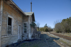
For this trip, we explored some of the communities that border the western banks of the Broad River. Our trip started with a quick tour around Prosperity, proper. We paused to let me take a couple of pictures of some of the old warehouses and the old train depot.

Prosperity Depot HDR HybridProsperity Depot Door HDR

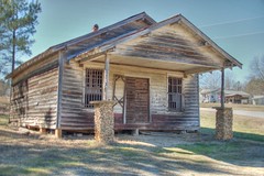
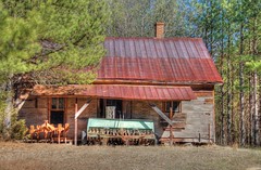
From Prosperity, we traveled to the little town of Pomaria, then turned onto New Hope Road just north of there. Dad was looking for a historic church he remembered visiting. While we passed several very old white frame churches, we didn’t find the one for which we were looking. We eventually reached the intersection of New Hope Road and Broad River Road, and paused so I could get a couple more shots of an old country store and a barn across the way.

New Hope Store HDRNew Hope Farm HDR

We headed south along the Broad River Road towards the town of Peak. The road wound through some very isolated areas, and crossed a couple of branches of Parr Shoals Reservoir. It was quite windy, and the lake was stirred with whitecaps.

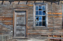
Peak is a U-shaped town. It’s limited by the Broad River on one side, with the train trestle being the only way across the river, apart from the main highway that bypasses the town. I was a bit disappointed that there weren’t more historic photogenic buildings, but the town does seem to be quite isolated.

I made particular note of the railroad, which has had the tracks removed. There are two prominent bridges/trestles in the area, and I understand that there is a move to convert these to trails. I also understand that the residents of Peak are against this. It’s my understanding that this has been resolved, and the railroad is set to become part of the Palmetto Trail system. I may have to come back this way with my mountain bike and explore a bit more.

We left Peak and meandered back towards Prosperity. It was a short Sunday outing, but I still got some good shots. I like to think of it as a scouting trip for further exploration.

Post navigation

❮ Previous Post: Pelham Mill Excursion
Next Post: RobotCam ❯

Leave a Reply Cancel reply

Your email address will not be published. Required fields are marked *

This site uses Akismet to reduce spam. Learn how your comment data is processed.

Categories

  • EdTech (200)
  • Entertainment (202)
  • Family (121)
  • Gear (115)
  • General Technology (99)
  • Geocaching and Maps (208)
  • History and Genealogy (266)
  • Internet (144)
  • Local (451)
  • Miscellaneous (550)
  • Music (196)
  • Paddling (248)
  • Photography (779)
  • Podcast (6)
  • Rambling (227)
  • Rants (161)
  • Recipes (34)
  • Religion (48)
  • Restaurants (165)
  • Science (48)
  • Things Overheard (29)
  • Travel (411)
  • Uncategorized (129)
  • Washington Sabbatical (113)
  • Weirdness (60)

Recent Posts

  • In Search of the Road Builder
  • The Phoenix Riots and Dr. Benjamin Mays – An MLK Day Ramble
  • An Obsession with Steak Knives
  • An Epiphany on Patriotism
  • Kayaking Bates Old River and Running Creek

Recent Comments

  • Walter Kokoszka on Mysterious Mayucha and The Wolf Pit
  • Elizabeth on The Temple of Health: Ground-Truthing in Antreville
  • The Bay Area Basketball Fan’s Guide to March Madness on FU All the Time!
  • Why You Should Root For This March Madness Underdog on FU All the Time!
  • Gregory Davis on Ghost Towns of the Pee Dee – Part 2, Centenary

Tags

blogging cemetery Christmas Columbia Edisto River edtech Entertainment family Flickr Florida Furman Furman University gear Georgia geotagging Ghost Town Ghost Towns Google Earth Google Maps GPS Greenville Greenville Chorale history Instructional Technology kayaking Lake Jocassee LCU Lowcountry Unfiltered maps Music North Carolina Paddling Photography rambling restaurant Restaurants review singing social networking South Carolina time-lapse Travel video Washington Washington State
March 2023
S M T W T F S
 1234
567891011
12131415161718
19202122232425
262728293031  
« Jan    

Copyright © 2023 Random Connections.

Theme: Oceanly by ScriptsTown