Early this week when I left work the sun was casting beautiful shadows across everything. I decided to take the long way home and look for something to photograph. My trek took me through the “Golden Box” area of Greenville, south of I-85 and the airport. This is the area after which all of the developers are lusting, but it still retains some vestiges of rural Greenville. It’s roughly bounded by Highway 101 on the east, Highway 14 on the West, I-85 on the north, and Reidville Road on the south.
I drove past our new elementary school under construction on Abner Creek Road and through the community of Liberty Hill. This is an interesting place that looks like it grew up around a prominent farm. I continued on Abner Creek across the Golden Box until I got to the community of Pelham, otherwise known as “Sugar Tit” by the locals, a reference to candy given to the children of the mill village.
I drove around the mill village that once was Pelham. It’s been bisected by the multi-lane Highway 14 and is in severe decline. I couldn’t believe the conditions of some of the houses where people were still living. I’m sure all of this will be bought up and turned into strip malls in the near future.
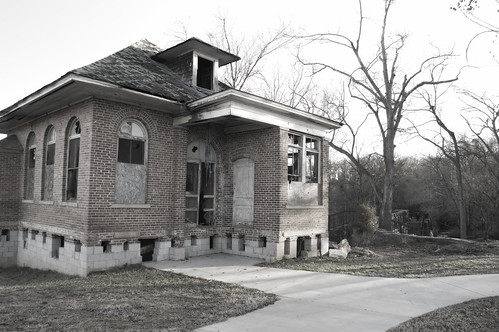
On the west side of the highway on the banks of the Enoree River one can see the remains of the old Pelham Mill, which supported the mill village, and the associated dam across the river. The most prominent structure is the old mill office building, which is in a severely dilapidated state. I wanted to get closer. There was a nice paved road a new parking area right next to the building which looked open to the public, but the entrance was also the entrance to a new water treatment plant. There was a truck parked in the area, and I wasn’t too sure if it was really public property. I decided to come back another day.
So, Thursday was another day, and another beautiful one at that. Rather than roaming all over Greenville I drive straight to Pelham Mill. This time there was no one around, so I drove on in and parked.
I guess I shouldn’t have worried about trespassing. There are several picnic tables, and this is obviously a park. Information that I’ve since been able to find online says that the park is temporarily closed and that it’s set to open again sometime this year. However, there was nothing to indicate that upon my visit.
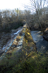
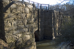
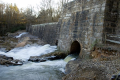
In addition to the old mill office building, there is a pathway leading to the top of the dam and a viewpoint where visitors can look both upstream and down. There is also a series of steps that leads up and over the dam to another viewpoint below, where visitors can see the spillways. On this visit there was lots of water coming through the spillways, and it made quite a noise.
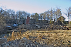
Below the spillway overlook are the brick ruins of the old mill itself. A remnant of a smokestack hovers of the corner of one foundation, and brick pilings march back from that. It is possible to walk down and explore the area. I was pleased to find that the area was relatively litter-free, with only an occasional piece of trash.
I stayed around and shot pictures until my camera battery ran low. All of my images from that trip can be seen here. This is already a great place to visit, but I’m hoping that are able to save the old office building. I look forward to when the park is officially reopened.
Great shot of the old office, Tom. Until about six years ago when the road was widened, the office was across the street. It was moved to the new location and there was a group raising money to renovate it. Guess they weren’t successful. The park at that time had become a hangout for “undesirables” so they closed it. But it’s an interesting place. The ruins are of a prominent textile factory that, I was told, was a major supplier of Confederate uniforms during the Civil War. Wonder if that’s true?
Stephen
I do seem to remember the old office being on the other side of the road.
As for Confederate uniforms, I don’t know.