Skip to content

Random Connections

A collection of photography and exploration focusing on Upstate South Carolina and beyond.

  • Home
  • About Us
  • Photos
  • Resources
  • Other Voices
  • Post Archives
  • Podcast
  • Home
  • Photography
  • Tilting the Space Needle

Tilting the Space Needle

Posted on September 24, 2007 By Tom 1 Comment on Tilting the Space Needle
Photography

Space Needle 1

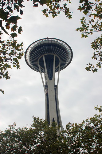
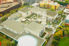
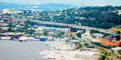
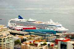
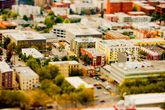
There was one batch of Washington photos that I think need special attention.  The Space Needle is a tilt-shifter’s dream come true.  You have 360 degrees of scenery, but it’s interesting enough to make great subject matter for fake tilt-shifts.  More importantly, the images aren’t distorted by window glass, so you’ve got even better starting material.

For tilt-shift to be effective, you need an overhead view. I tried some from the Peachtree Tower in Atlanta, but was never really happy with the results.  I got a decent tilt-shift from the Cumberland Gap overlook, but that was almost too far away.  The Space Needle isn’t so high that the surrounding neighborhoods lose their detail.  I think that’s whats missing from many aerial tilt-shifts – they are just too far away to be effective.

Regardless, here are a few the shots I shifted from that visit.  You really need to click on the links and view the images large to get the full effect…

Seattle 2

Seattle Neighborhood 1

Seattle 3

Seattle Science Museum 1

I5 and University of Washington

Cruise Ship

Monorail

Seattle 4

Post navigation

❮ Previous Post: Washington Photos
Next Post: Earth, Sky, and now Moon ❯

One thought on “Tilting the Space Needle”

  1. Ken C says:
    September 26, 2007 at 11:37 am

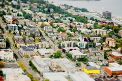
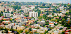
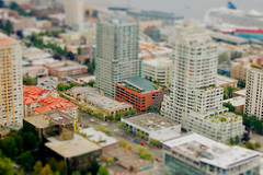
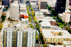
    Those cityscape pictures look eerily familliar. When i was in Junior High and High school, I drew these large cityscape pictures that were from about that kind of vantage point. Pen and color pencil. In mine, there were no cars to plug the streets. They were kind of my signature pieces for quite a few years. the origin was likely those drawings of the French countryside in teh Michelin travel guides. thing is, some of them were quite vast, with an amazing amount of detail. Brings back memories for sure.

    Reply

Leave a Reply Cancel reply

Your email address will not be published. Required fields are marked *

This site uses Akismet to reduce spam. Learn how your comment data is processed.

Categories

  • EdTech (197)
  • Entertainment (201)
  • Family (123)
  • Gear (114)
  • General Technology (98)
  • Geocaching and Maps (208)
  • History and Genealogy (275)
  • Internet (141)
  • Local (458)
  • Miscellaneous (557)
  • Music (202)
  • Paddling (265)
  • Photography (781)
  • Podcast (17)
  • Rambling (233)
  • Rants (161)
  • Recipes (36)
  • Religion (48)
  • Restaurants (165)
  • Science (48)
  • Things Overheard (29)
  • Travel (413)
  • Uncategorized (143)
  • Washington Sabbatical (113)
  • Weirdness (59)

Recent Posts

  • Carolina Ghost Towns – Mitchellville
  • Carolina Ghost Towns – Paper Towns
  • Kayaking on Wolf Creek Lake
  • Carolina Ghost Towns – Colonial Dorchester
  • Six Layer Bourbon Grits Bowl

Recent Comments

  • Eric Kincaid on Kayaking and Coffee
  • Daniel S Mawn on Remembering the Walke
  • Judy Hall on The Clock on Wade Hampton
  • Charles Johnson on In Search of the Road Builder
  • Anthony h hannig on From Kingsbury to Stoneboro – Rambling in Lancaster County

Tags

blogging cemetery Christmas Columbia Edisto River edtech Entertainment family Flickr Florida Furman Furman University gear Georgia geotagging Ghost Town Ghost Towns Google Earth Google Maps GPS Greenville Greenville Chorale history Instructional Technology kayaking Lake Jocassee LCU Lowcountry Unfiltered maps Music North Carolina Paddling Photography rambling restaurant Restaurants review singing social networking South Carolina time-lapse Travel video Washington Washington State
June 2025
S M T W T F S
1234567
891011121314
15161718192021
22232425262728
2930  
« May    

Copyright © 2025 Random Connections.

Theme: Oceanly by ScriptsTown