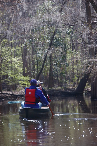
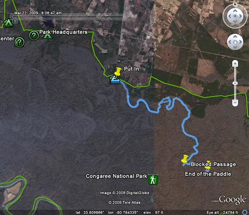
Early Saturday morning a small group of us gathered to paddle Cedar Creek, located in the Congaree Swamp National Park. Instead of kayaks, we decided that would take this trip in canoes. It turned out to be one of the longest paddling trips I’ve taken, covering about 6 miles of swamp, then paddling back.
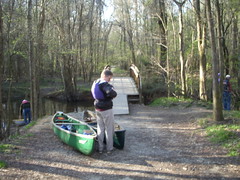
The issue of which boat to take was only resolved at the last minute. I knew Dwight was bringing his canoe. Whether or not I brought my kayak, or lugged my old battleship 15′ Coleman canoe depended on how many people decided to go. In the end, it was the Coleman, so I loaded it into the back of my pickup with about as much hanging off the tailgate as was actually in the bed of the truck.
Alan Russell and I met James Martin (who had joined us on our last flooded Congaree hike), Dwight Moffitt, and his friend Peter at the put in on South Cedar Creek Road. Dwight and Peter would be in one boat, Alan and I would be in mine, and James had his kayak. The plan was to paddle downstream a bit, then head back. According to Dwight this would take us through some of the more remote parks of the swamp, and away from the crowded boardwalks. Dwight assured us that paddling back upstream wouldn’t be a problem. Yeah, right.
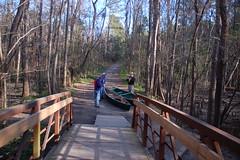
The access point is about 100 yards from the parking area, so we had to haul the boats. While steep, the access to the creek itself wasn’t too bad. At this point the trail continues over a bridge.
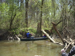
I’ve been doing so much kayaking lately that it took awhile adjust to the canoe. Not only was paddling and control different, but I had to get used to the stability (or lack thereof.) The old Coleman seemed very wobbly, especially with two of us in there. I also had forgotten how much space is available for cargo in a canoe, as opposed to a kayak. I was also impressed that as heavy as it is, the Coleman was was able to keep up with Dwight’s Bell.
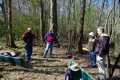
About a half mile from the put in we faced our first major obstacle. A deadfall completely blocked the stream, and there was no way through. A portage was required. As we lugged our boats across muddy banks, we saw another large group of canoeists launching from an access point just on the other side of the deadfall. We wondered how we might use that access point in the future and avoid the deadfall.
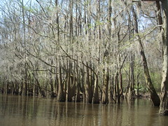
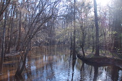
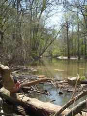
As Dwight had promised, the areas we paddled through were quite remote. Huge cypress trees lined the creek, and the flooded areas opened up side channels that could be confusing at times. Also, as promised, the current wasn’t strong, and we could paddle upstream when we took a notion to do so.

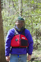
After a couple of hours of paddling we stopped for lunch. Dwight had to model his mosquito headwear while we checked the maps. I had my GPS running, but it was hard to gauge how for we had come. We figured we would paddle for a bit more, then turn and come back.
The channels got trickier and the current got stronger, but we pressed on. We should have taken it as a warning when Dwight said, “This is farther than I’ve ever been before.” We came to a place where another major channel branched off and it looked like it would take us to the Congaree River. We decided to head in that direction. However, just a few hundred yards down the channel we came to yet another deadfall. There was no getting through this one, either. We could have portaged, but it looked like there were more deadfalls downstream. We decided that perhaps we didn’t want to go to the river after all.
We took the other main channel, but now had no destination in mind. We had gone about another mile when it occurred to us A) it was getting late, B) the current was getting stronger, and C) we had to paddle all the way back. And so began the long journey home. At this point we ceased being sightseers and turned into machines. We stopped for one break at the exact same spot were we had lunch earlier, but for the most part kept going.
We finally reached the first deadfall that had caused us to detour, and decided to explore the access point. If it looked OK, we would just pull the boats out and walk to retrieve the cars. Dwight, James, and I went to explore, while Alan and Peter tended to the gear. We walked along a dirt road, past what appeared to be an experimental station. A little beyond that was a gate – apparently locked. This wasn’t going to work, so we trudged back down to the creek. Another party was pulling out, and told us that the gate wasn’t really locked. By this time we were so tired that we just dragged the boats on around the deadfall and kept going.
Finally we reached the take-out. It was about 6:30, and we had been on the river for about nine hours with only two fairly short breaks. Our arms ached, and with good reason. We had paddled nearly twelve miles. Even as tired as we were, it was fun, and I want to try this again.
Great account. Made me want to get the kayaks out. I live only about 20 minutes from the put-in you described and have paddled various stretches of Cedar Creek. At one point I thought I could talk the rangers into a remove-the-deadfall plan but they didn’t go for it. It seems to me by taking out the portages they could increase access. But they didn’t go for it.
The only thing missing from the account: Wildlife. Any birds?
I thought about that after writing this, Trey, and I did leave out wildlife descriptions. There were several ducks and a couple of kingfishers. I heard some palliated woodpeckers, but could only get a glimpse. Heard lots of barred owls.
To be honest, we were so busy paddling we didn’t take as much time to look as I would have liked. I had binoculars and a telephoto lens with me, but it seemed like we were paddling like crazy downstream to get to a certain point, then paddling like crazy just to make it back before dark. I prefer a more relaxed trip.
Hey Tom!
I recently paddled Cedar Creek in my new kayak (12′ pungo), and was looking for narratives just like this one to describe conditions one might expect downriver from South Cedar Creek Road landing. We paddled upstream for about an hour and a half (did this after work), with only one portage. Curious – are the trees as big and mysterious downstream from the bridge? Also, did you see anything that might work as a campsite along the way? Tempted to go on a solo yak-packing adventure this weekend to test out the new boat!
Patrick – depending on the water levels, the route is more open in some places, and can be completely blocked in others. There were sections where we were able to paddle multiple routes between huge cypress. Then there were some sections where we just couldn’t get through.
I know there are camping spots along the route from the Cedar Creek Landing to US 601. You would almost have to do that as an overnighter. I’m just not familiar with them.
Congrats on the new kayak! We’ll need to do some paddling together soon!
Hey Tom, you that man. Do you know what the minimum water gage levels would need to be to paddle this creek? Also, by the sound of your stroy, which I liked, there must not have been any rapids to be paddling back up….?
http://www.nps.gov/cong/planyourvisit/upload/canoe%20water%20level%20chart.pdf
I mean, You the man!