Even though most of my recent outings have involved kayaking, I haven’t abandoned my search for South Carolina’s lookout towers. I have the locations plotted on the GPS on my car, and as we have driven past I’ve made note of condition, and have stopped to check them out and photograph them, where possible.
This past trip took us by several towers, so I decided to document all of my findings over the last few months. Here they are..A couple of months ago I had a meeting in Columbia, and decided to check out a couple of locations west of the city.
Lake Murray Tower (33.997368°, -81.308990°)
First was the Lake Murray tower. I had my doubts about this one. A February 28, 2006 article in the State newspaper states that Tommy Hawkins purchased two towers from “a Lake Murray site Monday, and the other in Ballentine” to be dismantled and reconstructed on his farm in Fairfield County. I assumed this to be the Lake Murray Tower that was on my GPS. Sure enough, when I visited there was only a concrete base that remained.
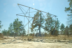
Gilbert Tower (33.879870°, -81.330935°)
The Gilbert Tower was a different story. I had Google Earth imagery that was showing the tower as intact. The tower was in the middle of nowhere, but I was able to find the location. Unfortunately, the tower was lying on its side. The cab was nowhere to be seen. Alas.
On my recent kayaking trip to Beaufort I was able to verify another tower.
Sheldon Tower (32.601850°, -80.791495°)
Sheldon Tower is on Highway 17, and should be clearly visible from that main road. I didn’t see it at all as I drove past. I assume it’s not there anymore.
And finally, on this most recent trip I caught several more towers. Our route took us by more locations, but I wasn’t paying attention at the time. Otherwise, I could have confirmed even more towers.
Cottageville Tower (32.925728°, -80.421212°)
We caught this one on the drive from Beidler Forest to the ACE Basin. The tower is no longer there, and has been replaced with a modern communications/cell phone tower.
Bull Island Tower (32.983333°, -79.600000°)
This one was a surprise, as it wasn’t really on our list. While at the Cape Romaine landing a tower was clearly visible out on Bull Island. So, I’m assuming that’s it’s name. I couldn’t determine its condition from this distance.
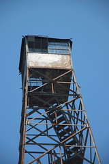
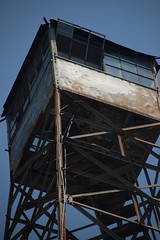
McClellanville Tower (33.081558°, -79.459508°)
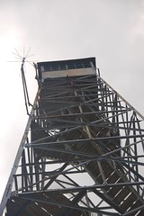
The McClellanville Tower was one of my must-see destinations for this trip. The tower is located in the town park, and one article I’d read said that there were plans to incorporate the tower into the local history museum and open it to the public.
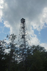
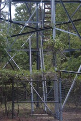
Alas, the tower wasn’t open. The tower was in excellent condition, but there was a tall fence and No Trespassing signs.

Honey Hill Tower (33.173502°-79.561179°)
This is another one that snuck up on us. I spotted it on the GPS just as we were approaching. The tower was off to the left, and looked to be in good condition.
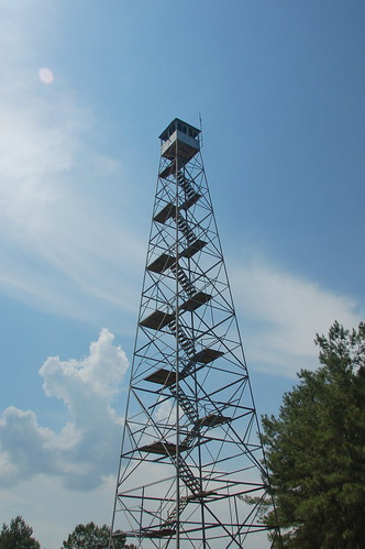
Pineville Tower (33.440776°, -80.066193°)
The Pineville Tower was at the entrance to a National Forest recreation area. It appeared to be in good condition, but the lowest set of steps had been removed.

So, one by one the towers are either confirmed or found to be missing. I’ve updated the data on my Fire Tower Google Earth File. Maybe this summer I’ll be able to knock out a few more of these in my furlough time.