Houston and I had another photo trek planned, but this time we had convinced our other brother, Steve, to join us. We rendezvoused at out parents house in Prosperity Friday night, then drove down to meet Steve the next morning.
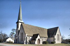
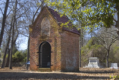
Our first stop was Holy Cross Episcopal Church. This church is made of “rammed earth.” Basically, a form is made and earth is packed inside. Holy Cross is also the burial place of Joel R. Poinsett.
The church hasn’t been used since 2000. Apparently there has been extensive termite damage. However, the church has received a grant to restore the facility.
The town of Stateburg doesn’t really exist anymore, although at one point it was a thriving area. Thomas Sumter had wanted Stateburg to be the state capital, hence the name.
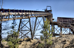
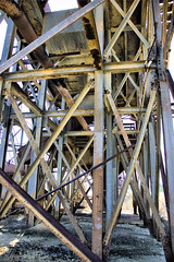
We drove through some fairly desolate countryside and came to a place that looked like an old mine or quarry. We didn’t see any No Trespassing signs, so we decided to explore. Desolation is an understatement. The mine was abandoned, with only rusting equipment left in place.
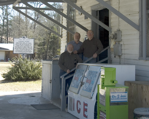
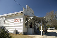
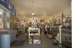
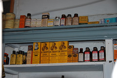
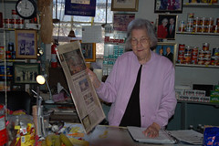
Soon we found ourselves in the community of Horatio, and stopped at the Lenoir Store. The Lenoir Store opened in 1760 and has been run by the Lenoir family that entire time. Inside we met 87 year old Carrie Lenoir, the current proprietor and former post mistress. Apparently she also used to drive the town fire truck, and she has authored several legal texts. Photographs of her with various presidents and politicians line the wall behind the counter. Quite a woman. The store itself is a step back in time. Antique remedies line the walls along with modern goods. We stayed for quite awhile talking to Mrs. Lenoir and her daughter.
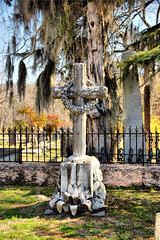
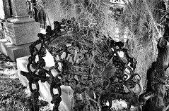
From Horatio and the Lenoir store we set our sites on the Thomas Sumter Memorial Park. Unfortunately, by this time I was feeling pretty lousy. I had picked up a bug, and it was getting progressively worse as the day wore on. The park itself was in a relatively obscure location. I didn’t even get out of the car, but let Steve and Houston explore and take pictures of General Sumter’s grave site.
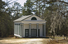
Our route took us by the High Hills Baptist Church of Santee. This was an unusual looking white frame church with lots of green trim. It was located behind a chain-linked fence. Houston was able to get through the gate to take some closer shots, but I planned to just hang out at the car. As we were there, a man pulled up in a truck and invited us to come in and get a glimpse of the inside of the church.
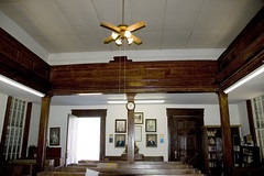
The interior was very simple, but its most prominent feature was the old slave gallery. Unlike a normal church balcony, the slave gallery was located very high so that the slaves would not be seen, nor could they really participate in the service. There was a separate exterior entrance for the slaves. We really wanted to go up for a look, but our tour guide told us that they had some structural problems.
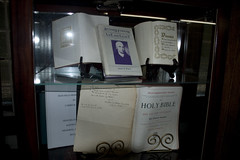
High Hills Baptist is also known as one of the first pastorates for Richard Furman, founder of Furman University. There were portraits of Furman around the church, and a cabinet with books and other historical documents on display. As sick as I felt, I was glad that I got out of the car to explore.
By this time, I really was feeling sick, and it was only noon. Our plans had originally called for more exploration in this area with Steve, then Houston and I were going to check out some spots in Fairfield County on the way home the next day. That just wasn’t going to happen. Houston drove me back to Prosperity, and I managed to make my way home from there. Despite the illness, it was a good trip, and I hope to have more like it.
Cool trip. I thought Holy Cross was as beautiful a church from the outside as I’ve seen, but regretted not getting to go inside. Likewise with Furman’s church; we didn’t get to go in. That is an intriguing area that kinda got left behind as the state grew elsewhere. I was amazed at the vista from atop the bluffs over the Wateree River. “High Hills” is definitely not a misnomer. (My trip there was perhaps a decade ago.)
I’m a 5 x great granddaughter of Richard Furman. I’m trying to determine exactly where the High Hills of the Santee is. Could anyone give me a general idea, especially the names of highways and roadways it is near? Any other information about the location would be appreciated.
Felicia Furman
Felicia – the church is located off of Garners Ferry Road, between Columbia and Sumter. Here’s a link to the Google Map – https://www.google.com/maps/place/High+Hills+Baptist+Church/@33.9786773,-80.5390924,13z/data=!4m2!3m1!1s0x88ff5cbcd3c2aa97:0xa61372176a88be81