Skip to content

Random Connections

A collection of photography and exploration focusing on Upstate South Carolina and beyond.

  • Home
  • About Us
  • Photos
  • Resources
  • Other Voices
  • Post Archives
  • Home
  • Travel
  • Do You Know the Way to San Jose?

Do You Know the Way to San Jose?

Posted on June 3, 2008 By Tom No Comments on Do You Know the Way to San Jose?
Travel

Wing

Apparently we do.

Our flight left at a leisurely mid-morning, with a brief stop in Dallas. We said goodbye to the cats, loaded up my camera gear, and headed to GSP.

The flight to Dallas was uneventful, just as we like. Hanging out in the Dallas airport we sat and watched the crowds, mostly consisting of self-absorbed business-types with cell phones firmly implanted. One woman boarded the next leg of the flight with us, spewing a constant stream of business babble that sounded like it was created by some automatic online jargon generator. Please airlines, never allow cell phones on fliights. We need some escape from this.

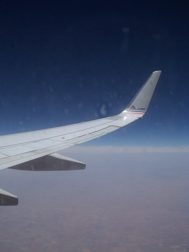
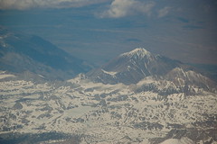
The flight from Dallas to San Jose took us across some spectacular scenery. We had great views of the Grand Canyon, Lake Meade, and the Sierra Nevadas.

Grand Canyon from the airSIerra Nevadas from air

We arrived to absolutely beautiful weather in San Jose. The airport is under construction, so finding our way around was a challenge. When we got to our rental car location we had another surprise. The only car available for us was a Chrysler Sebring convertible. How terrible. Instead of the Chevy Malibu we had expected to drive around the coast of California, we had to take this convertible.

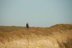
We got settled in our hotel, had a quick dinner, and Laura decided she needed to see ocean. We dropped the top on the car and took highway 17 southwest to Santa Cruz. The road from San Jose to Santa Cruz is beautiful, but a challenge to drive, especially at rush hour. We made it to Santa Cruz, then faced the challenge of finding beach access. Our first attempt took us to a large seaside amusement park, but not what we wanted. We did find one overlook, but decided it was a bit crowded. We were also on the south side of a peninsula, so a sunset view wasn’t to be had. We decided to continue up highway 1 north toward Half Moon Bay.

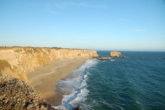
Highway 1 is known for its spectacular views of the Pacific, and this stretch is especially scenic. There is very little development along this stretch. Farms spread out all the way down to the ocean, and there are cliffs overlooking the beaches. We stopped at several overlooks, and found us a place to let the sun sink into the ocean.

California CoastLaura on Cliff

We continued on up to Half Moon Bay, then took a road back across the mountains and back to San Jose. By this time we had been traveling for hours. We collapsed back at our hotel.

Since I don’t have Photoshop on this laptop, I’m only uploading one or two photos at a time. There will be more when we get back and I get a chance to process the images.

Tags: California Photography Travel

Post navigation

❮ Previous Post: Cul-de-sac Party
Next Post: Bridges, Woods, Fog, and Wind ❯

Leave a Reply Cancel reply

Your email address will not be published. Required fields are marked *

This site uses Akismet to reduce spam. Learn how your comment data is processed.

Categories

  • EdTech (200)
  • Entertainment (202)
  • Family (121)
  • Gear (115)
  • General Technology (99)
  • Geocaching and Maps (208)
  • History and Genealogy (266)
  • Internet (144)
  • Local (451)
  • Miscellaneous (550)
  • Music (196)
  • Paddling (248)
  • Photography (779)
  • Podcast (6)
  • Rambling (227)
  • Rants (161)
  • Recipes (34)
  • Religion (48)
  • Restaurants (165)
  • Science (48)
  • Things Overheard (29)
  • Travel (411)
  • Uncategorized (129)
  • Washington Sabbatical (113)
  • Weirdness (60)

Recent Posts

  • In Search of the Road Builder
  • The Phoenix Riots and Dr. Benjamin Mays – An MLK Day Ramble
  • An Obsession with Steak Knives
  • An Epiphany on Patriotism
  • Kayaking Bates Old River and Running Creek

Recent Comments

  • Walter Kokoszka on Mysterious Mayucha and The Wolf Pit
  • Elizabeth on The Temple of Health: Ground-Truthing in Antreville
  • The Bay Area Basketball Fan’s Guide to March Madness on FU All the Time!
  • Why You Should Root For This March Madness Underdog on FU All the Time!
  • Gregory Davis on Ghost Towns of the Pee Dee – Part 2, Centenary

Tags

blogging cemetery Christmas Columbia Edisto River edtech Entertainment family Flickr Florida Furman Furman University gear Georgia geotagging Ghost Town Ghost Towns Google Earth Google Maps GPS Greenville Greenville Chorale history Instructional Technology kayaking Lake Jocassee LCU Lowcountry Unfiltered maps Music North Carolina Paddling Photography rambling restaurant Restaurants review singing social networking South Carolina time-lapse Travel video Washington Washington State
March 2023
S M T W T F S
 1234
567891011
12131415161718
19202122232425
262728293031  
« Jan    

Copyright © 2023 Random Connections.

Theme: Oceanly by ScriptsTown