We decided that today’s travels would take us north. Our plans were to explore the Golden Gate area, Muir Woods, and Point Reyes.
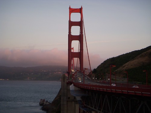
After a breakfast at the hotel, we dropped the top on the convertible and headed north. As we approached San Francisco the fog increased, and soon it was so thick it was just shy of a light rain. We continue on with the top down, regardless. We made our way along Highway 1 through the city until we got to the Golden Gate Bridge.
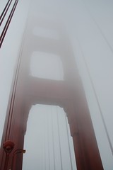
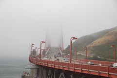
The bridge was almost invisible in the fog. As we drove across, Laura snapped pictures. We stopped at the vista point on the other side of the bridge and started taking more shots. We then took the pedestrian walkway across the bridge to the first tower. It was a bit cold and windy, so we decided that was about as far as we could make it.

From the bridge we drove on up through Sausolita and continued along Highway 1 toward Muir Woods. The road at this point is incredibly narrow and twists and turns through the canyons. It is quite the drive. The fog still hung over everything, but it seemed a bit clearer where we were going.
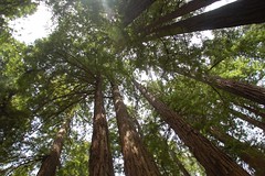
Eventually we reached the woods. The tour buses looked a bit ominous, but we continued on. The last time we were here we pretty much had the place to ourselves, but this time it looked like we would have company.
Laura and walked the paved trail, pausing to meditate among the redwoods. The trees were as impressive as ever. However, the smaller oaks are being killed off by some disease that was hit in 2005. There were lots of brown leaves on dying trees.
We got to Cathedral Grove and a sign indicated that this was to be a quiet zone. Of course, that only works if your visitors can read signs written in English. Several spoke loudly in foreign tongues, disrupting the meditative spirit.

Since it was lunch, we stopped at the local cafe for sandwiches, then browsed through the gift shop.
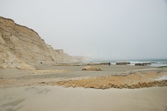
We continued northward(ish) along Highway 1. The road twists so much that you’re never really headed in one direction for long, but the overall effect is northward. There were supposed to be fabulous views of the coast from the road, but the fog really socked things in. We stopped at the Muir Beach overlook, and thought we had arrived at the end of the world.

The road eventually descended out of the fog and we reached the valleys leading out to Point Reyes. The road out to the point was much, much longer than I thought. It continued it’s narrow, twisty path. As we headed westward, the fog descended again. We passed historic ranches with cows bathed in fog.
Finally we reached the parking area for the Point Reyes Lighthouse. It was cold, windy, and foggy, and the sign stating that the lighthouse was closed today did not lift our spirits above the weather. Disregarding the sign, we decided to try to hike the half-mile to the point to at least catch a glimpse of the lighthouse.
The wind and mist increased as we continued. The path was lined with yellow lupine that would probably be gorgeous on a sunny day, but now just looked dreary. We did stop to admire the amazing rock formations that led up to the lighthouse. When we got to the lighthouse, we found a locked gate, and beyond that a steep set of stairs leading down to the light, proper. The lighthouse itself was nowhere to be seen in the fog. I lingered in the biting wind for a bit, hoping against hope that it would clear. It became all to apparent that nature was against us today, so we hiked back.
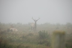
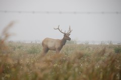
I had spotted Drakes Beach on the map, and it looked like it was on the leeward side of the point. Being out of the wind, yet being near surf was appealing, so we took the side road out that way. The beach was a bit calmer, but only marginally. We looked in the tide pools and watched gulls fly along the cliffs for a bit, then headed on back. Along the road we saw one car stopped, and saw that a herd of elk were resting in the fog nearby.
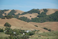
As we approached the main road further inland, the fog gave way to blue skies. We decided we really needed some coffee to counteract the fog’s effects, so we stopped briefly at Point Reyes Station, a quaint little town on Highway 1. Our plan had been to drive on up to Bodega Bay, infamous as the setting for Alfred Hitchcock’s “The Birds.” However, after reading the guidebooks and looking at maps, we decided to cut across to US 101, have dinner, then head back toward San Jose.
We drove across spectacular rolling hills dotted with farms. The brown grasses, green trees, and blue skies created a wonder palette of earth tones.
Soon we reached the town of Petaluma. Laura and I both wondered why the name, apart from being unusual, sounded so familiar to us. I finally figured out that it was because it sounded so much like “Metaluna”, the mythical planet from the 1950’s SciFi classic, This Island Earth. Laura couldn’t remember why the name stuck with her.
Regardless, it was a lovely little town on the banks of a river. We walked along the main street and riverfront for a bit, then found a little Italian restaurant called Rissibissi’s. The food was incredible, highlighted with a local pinot noire from the nearby Sonoma Valley.
Our plan had been to cross the other two bay bridges the evening, just to say that we had done so. However, we were tired, and that would take us miles out of our way, so we decided on the direct route back across the Golden Gate. When we got there, the skies were clear, and the setting sun was lighting up the bridge and the city across the bay. We stopped for just a few more shots, then headed on back for the evening.
What an awesome job describing your day.