On our latest Lowcountry Unfiltered trip down to Bonneau Ferry I enjoyed creating some composite images from old photographs. These show a historic photo of of the plantation superimposed over a present-day photo. The photos proved popular, and I wondered if I could do more with local historic photos.
I love historic photos. I’m a sucker for those little historic images books from Arcadia Press. When I first got involved with multimedia design for the classroom, one of my first projects was to create an interactive display comparing historic images of Greenville taken from the same vantage point over time.
Finding suitable images can be tricky. Copyright issues aside, I could scan the images from my books, but I’d prefer to find something available online. The best, most extensive collection is the Coxe Collection. The Greenville Historical Society has those locked away, available only at low resolution and watermarked to hell and back. The Library of Congress has some good images, as do the South Carolina Digital Library collection and the Greenville County Library.
Recently I discovered that Greenville History Tours had been posting some cool photos of Greenville on their Facebook page. Some of these were perfect for my project, and I spent one afternoon greedily downloading images from their site.
Thursday of this week was a beautiful day, and seemed like a perfect opportunity to put my project to the test. I printed out copies of the historic images so that I could try to line up my photos with the original. I think some of these turned out quite well. I’m going to be posting larger than usual images in this post because of the nature of the project, so I apologize ahead of time to the bandwidth-challenged.
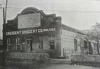
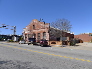
After a wonderful brisket quesadilla at Mac’s Speed Shop, I stopped at an old warehouse that used to house the Crescent Grocery Store, located just down from Fluor Field on Pendleton Street. It now has professional offices, but some years ago there was an indoor climbing venue here. Here’s the historic view:
Here’s the photo I took (one of many):
…and here’s the composite:
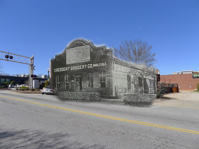
Even though I had the historic photo with me, lining up an exact angle to match is tricky. I didn’t get it exactly right in the image above, and had to do a bit of image distortion in Photoshop to get it to work.
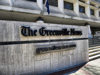
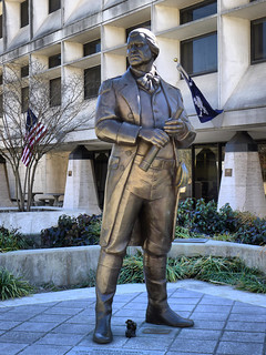
The next target was the Main Street Bridge over the Reedy River and the Falls Park area. I drove from the Flour Field area down Main, and parked around on Spring Street. As I rounded the block I paused to take a few photos of the Greenville News Building, now scheduled for demolition. I guess someday I may be using these photos to create a now and then image with whatever comes next. I did take some photos of the statue of Greenville’s namesake, Nathaniel Greene.
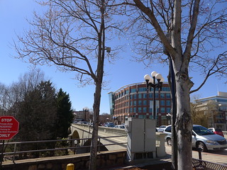
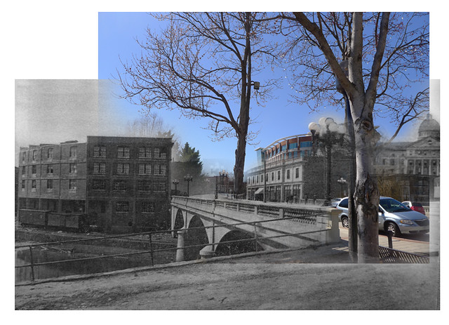
I continue toward the Main Street Bridge where I had three photos I wanted to recreate. First up is this image of the bridge:
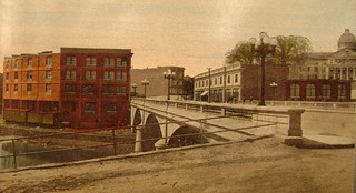
What I love about this image is that the dramatic dome of Chicora Collage looms above the river on the right. It looks like it was a beautiful building, and I wish it could have been preserved (though I think it was destroyed by fire.) I tried to match up the photo I took as best as I could:
In the modern photo a couple of cedar trees block the view of the restored Falls Building. I left a bit of Falls Place where High Cotton is located to show the context. Here is the composite image:
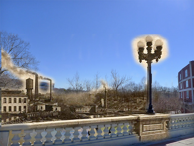
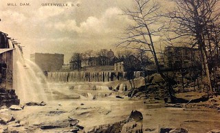
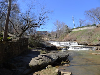
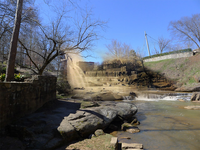
In the middle of the bridge I had an image looking downstream that shows the textile mills that lined the river. Just below the falls the river was dammed, and another mill was located below it:
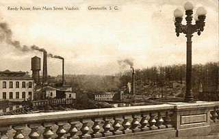
Amazingly, I was able to find the exact spot based on the concrete guardrail and light fixtures. The modern light fixtures are reproductions and are slightly different, but are pretty darn close.
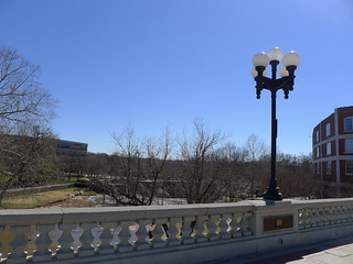
As with the previous two images, it wasn’t an exact match, but was very close. Here is the composite, with the overlay very obvious in sepia:
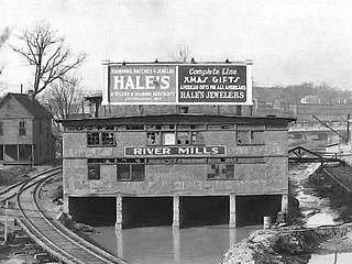
On the other side of the street, looking up stream I had a view of the Reedy from sometime between 1920 and 1940. Railroads crisscrossed the area, including the Swamp Rabbit. In the middle of the river was River Mills. The house on the left is in about the same location as the O-Cha Tea Bar. In this photo it features a billboard advertising Christmas goods that would have been clearly visible from the Main Street Bridge:
Here’s the photo that I took:
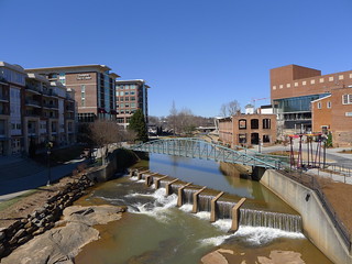
I think this one turned out best of all of the composite photos I created. It was easy to line up the Swamp Rabbit trestle with the present-day dam. Most helpful, though, was the River Street Bridge in the background. I was able to match it up almost exactly.
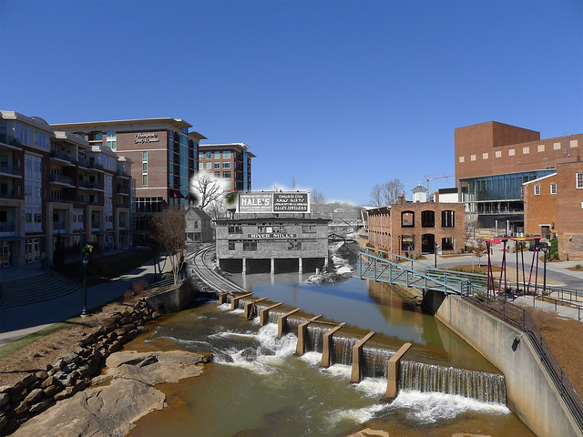
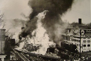
River Mill burned in the 1940s. In this image you can see the railroads even more clearly, including the old Duke’s Mayonnaise building, now the Wyche Pavilion.
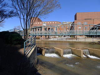
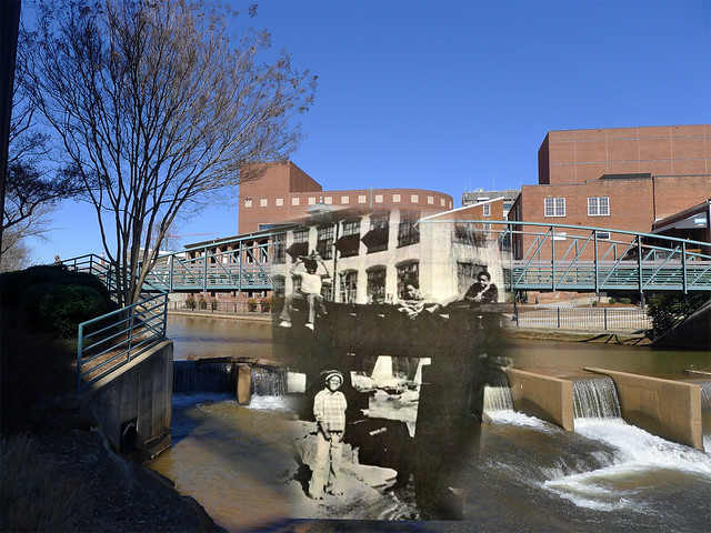
Down next to the river I had another target. I had a 1973 photo of some kids playing on the old Swamp Rabbit trestle. In the background is the Duke’s Mayonnaise building. The front part of that building was demolished, and the rear was preserved as the Wyche Pavilion.
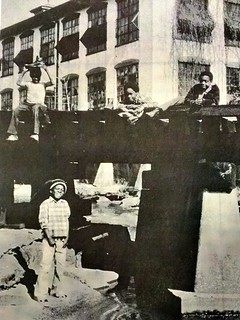
Trying to get this one lined up was especially tricky. I had to guess where the building extended.
I wasn’t entirely successful. I had to do quite a bit of distortion in order to get it to fit. I tried to use the cupola on top of the building , which was visible in both images, for alignment.
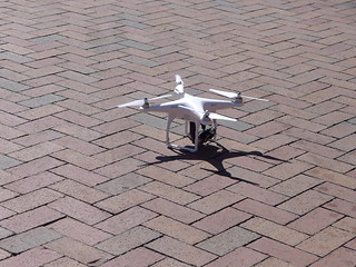
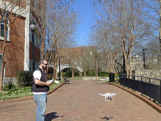
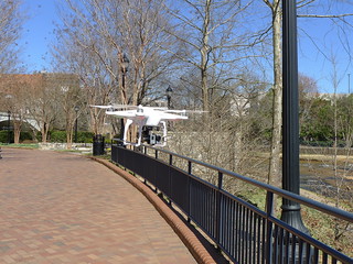
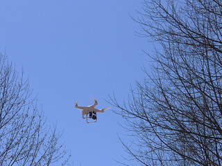
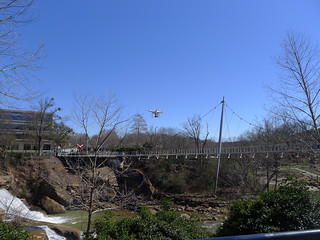
As I walked on into the park a spotted something that made me intensely jealous. A guy was out flying a Phantom quadcopter over the falls. I paused to chat and express my admiration. The guy was a professional videographer, and had just gotten the unit. He was testing it out before going on a shoot this weekend.
I had a view of Falls Cottage, aka Mary’s Restaurant before the park was restored:
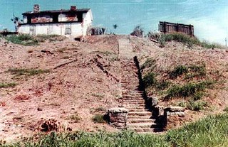
At first I thought the structure on the right was another building, but I think it was a billboard. I tried to line this up with the steps as best as possible:
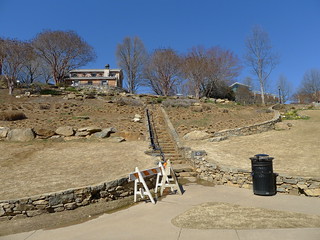
It looks like the steps extended all the way up to the street at one time. Now the gardens block that path. In this winter shot, though, this doesn’t look much better than pre-restoration with all of the brown grass.
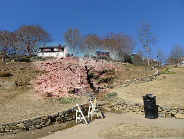
Here’s the composite result:
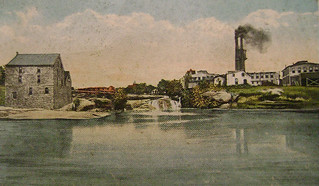
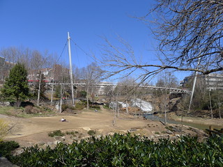
Down at the base of the falls across the river I wanted to match up one of the classic scenes of Greenville. Here’s one version, an old post card showing the old mills, with McBee Mill on the left bank and Camperdown Mill on the right bank:
Again, I had to make several attempts to get everything lined up. I took several photos from different angles.
Here’s the composite:
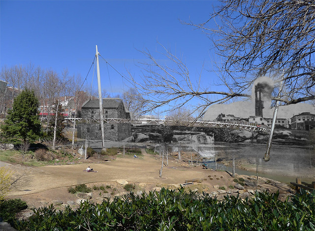
A brick wall is all that remains of McBee Mill, and can be seen along the walkways just below the Liberty Bridge:
I had one last photo I wanted to attempt before I got a parking ticket. Further downstream I had a photo of the mills that showed the dam and a clear view of Chicora College.
This one was trickier, still. I couldn’t get to the exact spot without getting my feet wet. I got as close as I could.
When I put the two together, I was able to match up the building at the top of the hill almost exactly. I knew I had the correct angle. The results weren’t great, though, because I couldn’t match the wall with water running over it.
I think I got some good results. Now I want to do more of these. I may also experiment with some other methods of doing overlays, such as animated GIFs or some sort of video, where one image fades into the other. Another may be a half and half composite. Those will work best for street scenes where there isn’t a clear landmark. We’ll see. Until then, this was a good start.
These are great! I especially like the one featuring River Mill and the one featuring McBee Mill.
Good stuff Tom.
as it so happens civillian drone usage is in the news today–some of the legal obstacles to quadcopter-cams might be falling away. http://motherboard.vice.com/read/commercial-drones-are-completely-legal-a-federal-judge-ruled
These are phenomenal! Could look at them for hours. They belong in our History Museum. It is so interesting the way you have done them. THank you!!
Fantastic!