Skip to content

Random Connections

A collection of photography and exploration focusing on Upstate South Carolina and beyond.

  • Home
  • About Us
  • Photos
  • Resources
  • Other Voices
  • Post Archives
  • Podcast
  • Home
  • Geocaching and Maps
  • Page 16

Category: Geocaching and Maps

0

Paddle Journeys and RiverVentures

Posted on September 2, 2007 By Tom No Comments on Paddle Journeys and RiverVentures
EdTech, Geocaching and Maps, Local, Travel

I mentioned briefly that I was working on a project with SCETV. That project is about to get off the ground. On September 6, nature photographer Richard Bernabe will begin a journey from the North Carolina border paddling all the way to the Charleston Harbor. SCETV will follow Bernabe through its RiverVenture series on the … Read More “Paddle Journeys and RiverVentures” »

Google Maps Gets Even Easier

Posted on August 23, 2007 By Tom No Comments on Google Maps Gets Even Easier
Geocaching and Maps, Internet

Google was on a roll yesterday with new product releases. Google Sky took the limelight, but there was another little change that seemed somewhat inconsequential, but has far-reaching implications for the wider use of Google Maps in applications all over the web. If you go to Google Maps and enter any address, you will see the following in the upper right corner of the map…

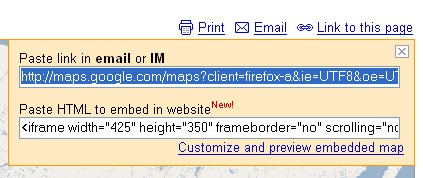
Clicking on the “Link to this page” link brings up a dialog box with two boxes of information. The first is a direct link to the map. The second is a bit of HTML which will let you embed the map into various web pages.

Prior to this little innovation, users could either link directly to the Google Maps page, or they could go through the process of getting a Google Maps API, setting up the javascript code, then hoping that it all worked in their particular map. Embedding maps into Blogger and other hosted sites was difficult, at best. With this new application, it’s a snap. For example, if I wanted to show the location of the restaurant where I had dinner last night, it’s not problem. I find it in maps and use this new embed feature.


View Larger Map

The only problem is that sometimes the iframe HTML tag isn’t interpreted correctly within the WordPress framework. Other than that, it’s a snap.

Read More “Google Maps Gets Even Easier” »

The pipes, the pipes are calling

Posted on August 22, 2007 By Tom 2 Comments on The pipes, the pipes are calling
EdTech, Geocaching and Maps, Internet

For a couple of months now I’ve been playing with and trying to understand Yahoo Pipes. I’ve still got a lot to learn, but at least now I think I have enough understanding to write about it.

In its most basic form, Yahoo Pipes is a feed aggregator. You can take any RSS feed and view the output. If there happens to be geographic data in the feed, it will automatically parse that information and display it on a map. However, Pipes takes it a step further by providing tools for combining feeds from various sources, analyzing feeds for keywords or location data, or allowing users to input or control parameters for various feeds. For example, you could set up a Pipe to return RSS items from Craig’s List that shows red couches for sale within 30 miles of Greenville. In a stunning example of cooperation, Yahoo even plays nice with their rival, Google, and provides a link to a Google Earth KML output for any geocoded data.

Some of the most interesting items are the mash-ups that can be created. For example, one Pipe takes the feed from Reuters, parses it through the geonames.org RSS-to-geoRSS webservice, then displays the news items on a map. Another will takes the feed from the NY Times, analyzes it for key words, takes that output and uses it to find corresponding photographs in Flickr.

Read More “The pipes, the pipes are calling” »

Looking up instead of down – Google Sky

Posted on August 22, 2007 By Tom No Comments on Looking up instead of down – Google Sky
EdTech, Geocaching and Maps, Internet, Science

Today Google released a new version of Google Earth, version 4.2, which includes a cool new feature called Google Sky.  You can basically toggle between views – looking downward, then looking upward from the exact same lat/long coordinates for a view of the night sky.  A toggle button now appears on the toolbar that allows … Read More “Looking up instead of down – Google Sky” »

Native KML Support in Flickr

Posted on August 12, 2007 By Tom No Comments on Native KML Support in Flickr
Geocaching and Maps, Internet, Photography, Uncategorized

I’m not sure how this slipped past me.  Since I don’t pay attention to the RSS subscription notices on my Flickr page, I really hadn’t spotted it, but there it was…   …a direct link to a KML file for my Flickr photos.   But wait!  Since this is a network link, it dynamically updates, loading … Read More “Native KML Support in Flickr” »

Take It With You

Posted on July 19, 2007 By Tom No Comments on Take It With You
Geocaching and Maps

I love standards. When companies adopt and use these, it can make life so much easier. This is the case with the recently announced Garmin Communicator API. This new API allows developers to create applets that will allow geocoded web data to be sent directly to a GPS or downloaded as a GPX file. According … Read More “Take It With You” »

Geocaching with William

Posted on July 7, 2007 By Tom 1 Comment on Geocaching with William
Geocaching and Maps

I had gotten my nephew, William, hooked on geocaching sometime last fall.  For Christmas, he got a new GPS, and I had been promising I teach him how to use it and would take him geocaching again.  I finally got around to fulfilling that promise yesterday. First, I got Will set up with one of … Read More “Geocaching with William” »

Get ’em while you can

Posted on July 5, 2007 By Tom 1 Comment on Get ’em while you can
Gear, Geocaching and Maps

I needed a new power cable for my Garmin GPS. I’ve gone through three of these things since getting this GPS a couple of years ago. Two came apart, and one actually popped a fuse on the cigarette lighter on both of our cars. These things weren’t designed very well. The last one I bought … Read More “Get ’em while you can” »

Geotagging Dilemma

Posted on July 4, 2007 By Tom 1 Comment on Geotagging Dilemma
EdTech, Geocaching and Maps, Internet, Photography

A couple of days ago I mentioned about my problem with Flickr geotagging. The Flickr user in question didn’t limit her geotagging to just her residence, but seems to have polluted the entire area with pictures of herself in lingerie (or less.) Despite my earlier comments, none of them are family-friendly, and almost all of … Read More “Geotagging Dilemma” »

Google Voyeurism

Posted on June 29, 2007 By Tom 1 Comment on Google Voyeurism
Geocaching and Maps, Internet

As I’ve stated previously, the things that tend to generate the most buzz about Google Earth/Maps have been those of a more pruirient nature – bikini girls in StreetView, or supposedly topless sunbathers in Google Earth.  I’ve even been asked to block Google Earth because of bad language in its Panoramio application. So far I’ve … Read More “Google Voyeurism” »

Posts pagination

Previous 1 … 15 16 17 … 21 Next

Categories

  • EdTech (197)
  • Entertainment (202)
  • Family (124)
  • Gear (114)
  • General Technology (98)
  • Geocaching and Maps (208)
  • History and Genealogy (276)
  • Internet (142)
  • Local (459)
  • Miscellaneous (561)
  • Music (202)
  • Paddling (268)
  • Photography (782)
  • Podcast (21)
  • Rambling (234)
  • Rants (162)
  • Recipes (37)
  • Religion (48)
  • Restaurants (165)
  • Science (48)
  • Things Overheard (29)
  • Travel (413)
  • Uncategorized (144)
  • Washington Sabbatical (113)
  • Weirdness (61)

Recent Posts

  • A Trip to Lando
  • Carolina Ghost Towns – Fort Motte, South Carolina
  • Carolina Ghost Towns Season 3 Trailer
  • Thanksgiving at Home
  • Home!

Recent Comments

  • Virginia Pepper on A Trip to Lando
  • julie niemeyer on Perryville Pickin’ and Grinnin’
  • Heath H Cowart on The Haunting of Farr’s Bridge
  • Sheryl Gunter Bingham on Chasing the Swamp Rabbit – Part 3, Sievern and Edisto Academy
  • Jerome A Mann on Update on Ghost Town Research

Tags

blogging cemetery Christmas Columbia Edisto River edtech Entertainment family Flickr Florida Furman Furman University gear Georgia geotagging Ghost Town Ghost Towns Google Earth Google Maps GPS Greenville Greenville Chorale history Instructional Technology kayaking Lake Jocassee LCU Lowcountry Unfiltered maps Music North Carolina Paddling Photography rambling restaurant Restaurants review singing social networking South Carolina time-lapse Travel video Washington Washington State
January 2026
S M T W T F S
 123
45678910
11121314151617
18192021222324
25262728293031
« Dec    

Copyright © 2026 Random Connections.

Theme: Oceanly by ScriptsTown