Skip to content

Random Connections

A collection of photography and exploration focusing on Upstate South Carolina and beyond.

  • Home
  • About Us
  • Photos
  • Resources
  • Other Voices
  • Post Archives
  • Podcast
  • Home
  • Internet
  • Page 12

Category: Internet

Earth, Sky, and now Moon

Posted on September 29, 2007 By Tom No Comments on Earth, Sky, and now Moon
Geocaching and Maps, Internet

Google brought us the earth, then the sky.  So it was natural that they turn their sights to the moon.  Unlike Earth and Sky, Moon is not a separate application, but is accessed online similar to their Maps program.  Users can zoom in and out (to a certain extent) and can pan across the terrain … Read More “Earth, Sky, and now Moon” »

More Google Earth 4.2 Discoveries

Posted on September 5, 2007 By Tom No Comments on More Google Earth 4.2 Discoveries
Geocaching and Maps, Internet

The start of school has kept me very busy, to the point that I haven’t had a chance to explore Google Sky very much.  However, version 4.2 has some other enhancements that I’ll briefly mention.  First there’s the flight simulator hidden as an Easter egg.  Pressing CTRL-ALT-A will fired it up.  There’s already been lots … Read More “More Google Earth 4.2 Discoveries” »

Geotagging Workflow, revised

Posted on September 4, 2007 By Tom 5 Comments on Geotagging Workflow, revised
Gear, Geocaching and Maps, Internet, Photography

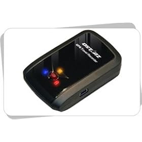
In preparation for an upcoming trip to Italy, Chip got a Qstarz BT-Q1000 GPS data recorder for his birthday. He wanted a small device that would record tracks for geotagging, but would be relatively inconspicuous. This fits the bill perfectly. As we played with this thing, both of us revised our workflows for geotagging images – Chip with his new gizmo and I with my trusty Garmin eTrex Legend. Here’s a breakdown of what I learned over the weekend…

Data Recorders

In an earlier post about geotagging workflow, my mantra was keep the GPS running. If you don’t have the geographic data, manual tagging is your only choice. At the time of that writing, there was only one real option for dedicated tracking for consumers – Sony’s GSP-CS1. That device was fraught with problems, from not being very accurate to taking too long to lock onto satellites. Sony has since updated the tracker, but it’s been joined by lots of other options.

Devices such as the BT-Q1000 have a new generation of GPS chipsets. These are more accurate, and can maintain satellite locks while in a pocket or in a backpack. This makes them much more convenient for travel, as you don’t have to have a bulky handheld GPSr with clear view of the sky all the time. Since there is no display, battery life is much better. The Qstarz unit boasts a 32 hour battery life.

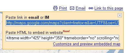
Not having an LCD screen isn’t a problem, though. Many of these, such as the BT-Q1000, have BlueTooth so that they can take advantage of the displays on mobile devices. As with discovered with the BT-Q1000, its BlueTooth function won’t allow export of track data. That has to be done through the USB connection.

Read More “Geotagging Workflow, revised” »

Google Maps Gets Even Easier

Posted on August 23, 2007 By Tom No Comments on Google Maps Gets Even Easier
Geocaching and Maps, Internet

Google was on a roll yesterday with new product releases. Google Sky took the limelight, but there was another little change that seemed somewhat inconsequential, but has far-reaching implications for the wider use of Google Maps in applications all over the web. If you go to Google Maps and enter any address, you will see the following in the upper right corner of the map…

Clicking on the “Link to this page” link brings up a dialog box with two boxes of information. The first is a direct link to the map. The second is a bit of HTML which will let you embed the map into various web pages.

Prior to this little innovation, users could either link directly to the Google Maps page, or they could go through the process of getting a Google Maps API, setting up the javascript code, then hoping that it all worked in their particular map. Embedding maps into Blogger and other hosted sites was difficult, at best. With this new application, it’s a snap. For example, if I wanted to show the location of the restaurant where I had dinner last night, it’s not problem. I find it in maps and use this new embed feature.


View Larger Map

The only problem is that sometimes the iframe HTML tag isn’t interpreted correctly within the WordPress framework. Other than that, it’s a snap.

Read More “Google Maps Gets Even Easier” »

The pipes, the pipes are calling

Posted on August 22, 2007 By Tom 2 Comments on The pipes, the pipes are calling
EdTech, Geocaching and Maps, Internet

For a couple of months now I’ve been playing with and trying to understand Yahoo Pipes. I’ve still got a lot to learn, but at least now I think I have enough understanding to write about it.

In its most basic form, Yahoo Pipes is a feed aggregator. You can take any RSS feed and view the output. If there happens to be geographic data in the feed, it will automatically parse that information and display it on a map. However, Pipes takes it a step further by providing tools for combining feeds from various sources, analyzing feeds for keywords or location data, or allowing users to input or control parameters for various feeds. For example, you could set up a Pipe to return RSS items from Craig’s List that shows red couches for sale within 30 miles of Greenville. In a stunning example of cooperation, Yahoo even plays nice with their rival, Google, and provides a link to a Google Earth KML output for any geocoded data.

Some of the most interesting items are the mash-ups that can be created. For example, one Pipe takes the feed from Reuters, parses it through the geonames.org RSS-to-geoRSS webservice, then displays the news items on a map. Another will takes the feed from the NY Times, analyzes it for key words, takes that output and uses it to find corresponding photographs in Flickr.

Read More “The pipes, the pipes are calling” »

Looking up instead of down – Google Sky

Posted on August 22, 2007 By Tom No Comments on Looking up instead of down – Google Sky
EdTech, Geocaching and Maps, Internet, Science

Today Google released a new version of Google Earth, version 4.2, which includes a cool new feature called Google Sky.  You can basically toggle between views – looking downward, then looking upward from the exact same lat/long coordinates for a view of the night sky.  A toggle button now appears on the toolbar that allows … Read More “Looking up instead of down – Google Sky” »

Native KML Support in Flickr

Posted on August 12, 2007 By Tom No Comments on Native KML Support in Flickr
Geocaching and Maps, Internet, Photography, Uncategorized

I’m not sure how this slipped past me.  Since I don’t pay attention to the RSS subscription notices on my Flickr page, I really hadn’t spotted it, but there it was…   …a direct link to a KML file for my Flickr photos.   But wait!  Since this is a network link, it dynamically updates, loading … Read More “Native KML Support in Flickr” »

It Just Doesn’t Fit

Posted on August 12, 2007 By Tom No Comments on It Just Doesn’t Fit
Internet

Confession time – I am not a neat person. This is born out by the deplorable state of both my home and work offices. For some reason, entropy intensifies around any space I occupy. While my real world may be cluttered, I like for my cyber worlds to be nice and neat. That means having … Read More “It Just Doesn’t Fit” »

Tumblin’ with Tumblr

Posted on July 15, 2007 By Tom No Comments on Tumblin’ with Tumblr
Internet

Chip hooked me up with a new blogging service called Tumblr.  The interface is super-simple, and there is an excellent "Share on Tumblr" applet that will automatically post videos, images, whatever into the Tumblr blog at the push of a button.  As Chip states in his tagline, "Tumblr, because I’m too lazy to blog." Having … Read More “Tumblin’ with Tumblr” »

Whither CB?

Posted on July 10, 2007 By Tom No Comments on Whither CB?
EdTech, Gear, Internet

I was reorganizing all the various gadgets I have in my car – GPS, XM, phone charger, etc.  All of these require power from the cigarette lighter, which got me thinking about probably the first device that used the lighter as a power outlet – the CB Radio. In pre-Internet days, the CB was the … Read More “Whither CB?” »

Posts pagination

Previous 1 … 11 12 13 … 15 Next

Categories

  • EdTech (197)
  • Entertainment (202)
  • Family (123)
  • Gear (114)
  • General Technology (98)
  • Geocaching and Maps (208)
  • History and Genealogy (275)
  • Internet (142)
  • Local (459)
  • Miscellaneous (560)
  • Music (202)
  • Paddling (268)
  • Photography (781)
  • Podcast (19)
  • Rambling (233)
  • Rants (162)
  • Recipes (37)
  • Religion (48)
  • Restaurants (165)
  • Science (48)
  • Things Overheard (29)
  • Travel (413)
  • Uncategorized (143)
  • Washington Sabbatical (113)
  • Weirdness (61)

Recent Posts

  • Helene One Year Later
  • Once Again, Up the Long Nose
  • Upstate Renaissance Faire
  • Exploring Lake Summit
  • The End of Days

Recent Comments

  • Gay on In Search of the Road Builder
  • Virgil Howell on The Ghost Towns of Lake Marion
  • Virgil Howell on Return to Ferguson
  • Mary Copeland Myers on Renno and Stomp Springs
  • Virginia Pepper on Helene One Year Later

Tags

blogging cemetery Christmas Columbia Edisto River edtech Entertainment family Flickr Florida Furman Furman University gear Georgia geotagging Ghost Town Ghost Towns Google Earth Google Maps GPS Greenville Greenville Chorale history Instructional Technology kayaking Lake Jocassee LCU Lowcountry Unfiltered maps Music North Carolina Paddling Photography rambling restaurant Restaurants review singing social networking South Carolina time-lapse Travel video Washington Washington State
October 2025
S M T W T F S
 1234
567891011
12131415161718
19202122232425
262728293031  
« Sep    

Copyright © 2025 Random Connections.

Theme: Oceanly by ScriptsTown