Skip to content

Random Connections

A collection of photography and exploration focusing on Upstate South Carolina and beyond.

  • Home
  • About Us
  • Photos
  • Resources
  • Other Voices
  • Post Archives
  • Podcast
  • Home
  • 2015
  • October

Month: October 2015

Pathfinders and Map Makers – Part One

Posted on October 28, 2015October 28, 2015 By Tom 3 Comments on Pathfinders and Map Makers – Part One
Geocaching and Maps, History and Genealogy

Pathfinder with Trailer

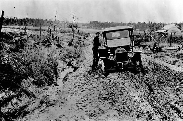
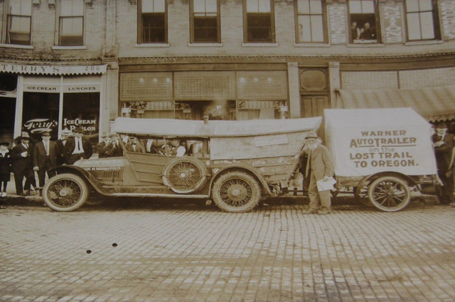
It was early 20th Century and cars were just coming into their own. However, the roads weren’t keeping up. Most were still dirt tracks at the best of times, and terrible mud pits at others. A cross-country trek was an adventure, and only for those with the means to obtain and maintain an automobile. Greater buy-in was needed from the general public so that bond initiatives and legislation could be passed. Thus was born the age of the Pathfinders, adventurous souls who sought out the best routes, laid out the paths for early highway systems, and brought to the public awareness of the need for good roads.

Read More “Pathfinders and Map Makers – Part One” »

In Search of Good Roads for South Carolina

Posted on October 27, 2015October 27, 2015 By Tom No Comments on In Search of Good Roads for South Carolina
Geocaching and Maps, History and Genealogy

NC Good Roads, Johnson County, circa 1909

The recent flooding in the mid-state has pointed out some of the glaring problems with South Carolina’s infrastructure. Even before the floods, the issue of deteriorating roads has been foremost, with discussion about how to fund road repairs. This isn’t a new problem, though. The question about how to develop and maintain adequate infrastructure is not a “one and done” proposition. First there was the King’s Road and Great Wagon Road, then in the 1820s it was the development of the Santee Canal and the State Road. The development, maintenance, and funding of an adequate means of transportation was, and always will continue to be an issue.

In the last post I made a few comments about the roads around Greenville – basically trails that connected town to town. The condition of those roads was often appalling. This was true for the entire country around the turn of 20th century. The automobile was just taking off, but getting anywhere proved to be a challenge. Thus, the Good Roads Movement was born.

Read More “In Search of Good Roads for South Carolina” »

The Streets of Greenville

Posted on October 22, 2015April 26, 2023 By Tom 3 Comments on The Streets of Greenville
Geocaching and Maps, History and Genealogy, Local

Greenville Map 1948

My late father-in-law had a problem with Greenville. He grew up in the wilds of Idaho along the Salmon River. However, he spent most of his adult life in large western cities, namely Los Angeles, where the streets are laid out in neat, tidy grids. Greenville’s streets always left him bewildered.

Whenever he gave me trouble about my hometown, I would reply that it makes perfect sense – Laurens Road goes to Laurens, Augusta Road goes to Augusta, etc. While that’s true, there are lots of other…questionable routes, and I could see how someone not from here would be very confused. Greenville’s streets are based on an early 19th Century design, and that pattern STILL influences our traffic.

Read More “The Streets of Greenville” »

Blue Ridge Getaway

Posted on October 14, 2015 By Tom No Comments on Blue Ridge Getaway
Photography, Travel

Great Smoky Mountains Railroad

Laura has a birthday coming up, but finding a time to celebrate has been problematic. We had decided to go a getaway the weekend before her birthday, but nature dealt us a blow. Our original plans were to head to Charleston and visit the ACE Basin, then head up to Beidler Forest. Obviously, with all of the flooding in the lower part of the state, that wasn’t going to happen. Instead, we decided to head north. I got us tickets for the Great Smoky Mountains Railroad. Turned out to be a peak fall color weekend, and a great getaway, even though it wasn’t Charleston.

Read More “Blue Ridge Getaway” »

Fall Paddle on Cascade Lake

Posted on October 13, 2015October 13, 2015 By Tom 1 Comment on Fall Paddle on Cascade Lake
Local, Paddling, Photography

Cascade Lake and Hooker Falls-20

The week had been absolutely beautiful. After the rains of last week this was a welcome change. Now we had clear October skies, the kind that make me love fall. It was also warm, and seemed like the perfect opportunity for a paddling trip.

I ran down my list of easy solo paddling venues. There were a couple that piqued my interest, but what I really wanted to do was paddle up to Hooker Falls on Cascade Lake. I was hoping that fall colors would make for some scenic kayaking.

Read More “Fall Paddle on Cascade Lake” »

Waterfalls and Flea Markets

Posted on October 13, 2015 By Tom No Comments on Waterfalls and Flea Markets
Local, Photography, Rambling

Liniment Bottles

With all of the rain that we had gotten over the past couple of days I figured the local waterfalls must be running at maximum. In fact, I’d already seen photos on Facebook of Reedy Falls with tremendous amounts of water. I decided to check it out.

Read More “Waterfalls and Flea Markets” »

Taylors to Marietta – A Midweek Ramble

Posted on October 10, 2015 By Tom No Comments on Taylors to Marietta – A Midweek Ramble
Local, Photography, Rambling

Geer Highway Gas

Even though I haven’t been able to finish my explorations of the Tobacco Trail, I haven’t been sitting idle. Once the rain stopped we had some spectacular weather, and I decided to get out and about. I hit a few spots in the upstate, so this is sort of a miscellany wrap-up of the week. This is part one of about a three-parter. This first part actually took place last week, before the deluge…

Read More “Taylors to Marietta – A Midweek Ramble” »

Tobacco Trail Flooding

Posted on October 9, 2015October 9, 2015 By Tom 2 Comments on Tobacco Trail Flooding
Miscellaneous

It’s as I feared. The floodwaters that inundated Columbia are now washing downstream. The image above is of Highway 301 between Manning and Turbeville, the very area I explored a couple of weeks ago. This image was posted on Facebook by John McLeod, a Manning Resident. He also posted this image just northeast of the … Read More “Tobacco Trail Flooding” »

100 Year Flooding

Posted on October 7, 2015 By Tom 3 Comments on 100 Year Flooding
Local
aptopix_east_coast_rainstorm_south_carolina.jpeg-0fbd0_0
Photo from Associated Press

The photos from Columbia have been astounding. The level of flooding is beyond anything we might have imagined. I have close friends that have been directly affected by the flooding, and getting back to normal will take months.

Here in Greenville we got lots of rain, and there had been some localized flooding, but nothing to the scale of the mid-state. Our area is almost back to normal.

Read More “100 Year Flooding” »

Categories

  • EdTech (197)
  • Entertainment (201)
  • Family (123)
  • Gear (114)
  • General Technology (98)
  • Geocaching and Maps (208)
  • History and Genealogy (275)
  • Internet (141)
  • Local (458)
  • Miscellaneous (557)
  • Music (202)
  • Paddling (265)
  • Photography (781)
  • Podcast (16)
  • Rambling (233)
  • Rants (161)
  • Recipes (36)
  • Religion (48)
  • Restaurants (165)
  • Science (48)
  • Things Overheard (29)
  • Travel (413)
  • Uncategorized (143)
  • Washington Sabbatical (113)
  • Weirdness (59)

Recent Posts

  • Carolina Ghost Towns – Paper Towns
  • Kayaking on Wolf Creek Lake
  • Carolina Ghost Towns – Colonial Dorchester
  • Six Layer Bourbon Grits Bowl
  • How’s the House? Part 2

Recent Comments

  • Eric Kincaid on Kayaking and Coffee
  • Daniel S Mawn on Remembering the Walke
  • Judy Hall on The Clock on Wade Hampton
  • Charles Johnson on In Search of the Road Builder
  • Anthony h hannig on From Kingsbury to Stoneboro – Rambling in Lancaster County

Tags

blogging cemetery Christmas Columbia Edisto River edtech Entertainment family Flickr Florida Furman Furman University gear Georgia geotagging Ghost Town Ghost Towns Google Earth Google Maps GPS Greenville Greenville Chorale history Instructional Technology kayaking Lake Jocassee LCU Lowcountry Unfiltered maps Music North Carolina Paddling Photography rambling restaurant Restaurants review singing social networking South Carolina time-lapse Travel video Washington Washington State
October 2015
S M T W T F S
 123
45678910
11121314151617
18192021222324
25262728293031
« Sep   Nov »

Copyright © 2025 Random Connections.

Theme: Oceanly by ScriptsTown