Skip to content

Random Connections

A collection of photography and exploration focusing on Upstate South Carolina and beyond.

  • Home
  • About Us
  • Photos
  • Resources
  • Other Voices
  • Post Archives
  • Podcast
  • Home
  • 2011
  • April
  • Page 2

Month: April 2011

Jury Duty

Posted on April 8, 2011 By Tom 3 Comments on Jury Duty
Miscellaneous

IMAG0430

A couple of weeks ago this nice little letter from Paul Wickenseimer, Clerk of Court for Greenville County, arrived in my mailbox…

IMAG0431

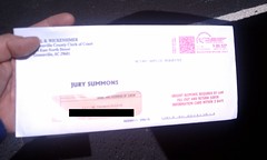
Yep, a jury summons. I was to start my round of civic duty April 4.  I just completed it, and it was an interesting, yet unfulfilling experience.

Read More “Jury Duty” »

Cool 3D Tools

Posted on April 6, 2011 By Tom No Comments on Cool 3D Tools
Photography

Dogwood Anaglyph

I’ve discovered a treasure trove of 3D tools. Japanese developer Muttyan has put together HUGE collection of applications for viewing and creating stereoscopic images and videos. These include side-by-side stereographs as well as anaglyphs using a variety of color and polarizing schemes.

Screen shot 2011-04-06 at 7.31.06 AM

Online since 2003, the site design looks like it’s stuck in the 1990’s, but the content is current and comprehensive, and that’s what matters.

I first stumbled onto the site looking for a way to create 3D views of Google Earth.  I had wondered if there was a way to create an off-set image that could be converted to anaglyphs.  I found Muttyan’s Stereo Google Earth page, and started exploring.

This page uses two instances of the Google Earth plugin to present side-by-side images of chosen locations.  I started with an overhead screen capture, such as this one of downtown Greenville…

Read More “Cool 3D Tools” »

Greenville Historical Aerial Imagery

Posted on April 5, 2011 By Tom 3 Comments on Greenville Historical Aerial Imagery
History and Genealogy, Internet, Local

Downtown Sanford 1920

Sometime last week the Greenville Cageliner had an article about a new website from the Greenville County GIS Office (http://gis.greenvillesc.gov/historicalimagery/). The website features historical aerial photography imagery as a map, similar to Google Earth. Images are available for 1955, 1965, 1979, 1989, 1997, and 2009, and cover the downtown area, along with a bit of the county. Also included is the Sanford Insurance Map of the city from 1920.

I could spend a HUGE amount of time exploring the site. Looking at how the city has changed over the decades has been fascinating, and somewhat depressing. The patterns of urban sprawl are quite clear at a distance, and it can be sad to look back on landmarks that are no longer there. On the other hand, there have been some marked improvements in areas such as along the banks of the Reedy River, and these images show that very clearly.

I started with the area around the old Furman campus. I had never really understood the location of the old bell tower in relation to the rest of the campus, but this imagery makes it very clear. (Click on the images for a larger view.)

Old Furman Campus 1955

Read More “Greenville Historical Aerial Imagery” »

Eight Years of Blogging

Posted on April 4, 2011 By Tom 1 Comment on Eight Years of Blogging
Miscellaneous

Today marks the eighth year I’ve been blogging in some fashion or other. I never thought I’d keep at it for so long, but here were are in 2011 and I’m still writing. In 2003 blogs were fairly rare, and most people had never even heard the term. I had seen a couple of blogs, … Read More “Eight Years of Blogging” »

Posts pagination

Previous 1 2

Categories

  • EdTech (197)
  • Entertainment (202)
  • Family (124)
  • Gear (114)
  • General Technology (98)
  • Geocaching and Maps (208)
  • History and Genealogy (276)
  • Internet (142)
  • Local (459)
  • Miscellaneous (561)
  • Music (202)
  • Paddling (268)
  • Photography (782)
  • Podcast (24)
  • Rambling (234)
  • Rants (162)
  • Recipes (37)
  • Religion (48)
  • Restaurants (165)
  • Science (48)
  • Things Overheard (29)
  • Travel (413)
  • Uncategorized (144)
  • Washington Sabbatical (113)
  • Weirdness (61)

Recent Posts

  • Carolina Ghost Towns – Proctor, NC
  • Carolina Ghost Towns – Judson, North Carolina
  • Carolina Ghost Towns – Madison, SC
  • A Trip to Lando
  • Carolina Ghost Towns – Fort Motte, South Carolina

Recent Comments

  • Pher on Dipping a Toe in the North Toe
  • Paula McCall on Memories of Echo Valley
  • Cash Lewis on The Sad Fate of Chappells
  • Cash Lewis on The Sad Fate of Chappells
  • Scott Clenney on Getting Pulled into Union County – Part 1, Buffalo

Tags

blogging cemetery Christmas Columbia Edisto River edtech Entertainment family Flickr Florida Furman Furman University gear Georgia geotagging Ghost Town Ghost Towns Google Earth Google Maps GPS Greenville Greenville Chorale history Instructional Technology kayaking Lake Jocassee LCU Lowcountry Unfiltered maps Music North Carolina Paddling Photography rambling restaurant Restaurants review singing social networking South Carolina time-lapse Travel video Washington Washington State
April 2011
S M T W T F S
 12
3456789
10111213141516
17181920212223
24252627282930
« Mar   May »

Copyright © 2026 Random Connections.

Theme: Oceanly by ScriptsTown