Skip to content

Random Connections

A collection of photography and exploration focusing on Upstate South Carolina and beyond.

  • Home
  • About Us
  • Photos
  • Resources
  • Other Voices
  • Post Archives
  • Podcast
  • Home
  • 2011
  • April
  • 27

Day: April 27, 2011

More on Elevation Profiles

Posted on April 27, 2011 By Tom No Comments on More on Elevation Profiles
EdTech, Geocaching and Maps

A couple of posts back I wrote about discovering Elevation Profiles for Paths in Google Earth. I’ve spent a little bit more time working with this, and came up with another neat activity for a classroom.

In the last post I created a path with only two endpoints – basically a straight-line cross section. I also did this across fairly large areas of land, entire states, in fact. This activity focuses in on the details a bit, and uses the directions section of Google Earth.

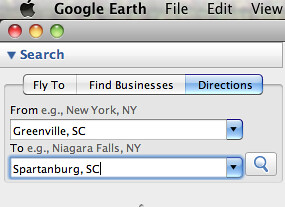
First, go to the Directions tab and input two locations. These can be addresses, lat-long coordinates, or any other type of locator. For this activity, I suggest keeping the distances fairly short, probably within about 50 miles. Here are some suggestions:

  • From your home to your school, workplace, or church
  • Between two cities
  • Between your house and your best friend’s house

In the example below, I used Greenville and Spartanburg.

Screen shot 2011-04-27 at 6.17.33 AM

When you hit Enter or click on the magnifying glass search icon, you get driving directions between the two cities. For some strange reason Google Earth chose Wade Hampton Boulevard instead of I-85. I guess it went with the shortest route rather than the quickest. No matter – I can still illustrate the point.
Read More “More on Elevation Profiles” »

Categories

  • EdTech (197)
  • Entertainment (202)
  • Family (123)
  • Gear (114)
  • General Technology (98)
  • Geocaching and Maps (208)
  • History and Genealogy (275)
  • Internet (142)
  • Local (459)
  • Miscellaneous (560)
  • Music (202)
  • Paddling (268)
  • Photography (781)
  • Podcast (19)
  • Rambling (233)
  • Rants (162)
  • Recipes (37)
  • Religion (48)
  • Restaurants (165)
  • Science (48)
  • Things Overheard (29)
  • Travel (413)
  • Uncategorized (143)
  • Washington Sabbatical (113)
  • Weirdness (61)

Recent Posts

  • Helene One Year Later
  • Once Again, Up the Long Nose
  • Upstate Renaissance Faire
  • Exploring Lake Summit
  • The End of Days

Recent Comments

  • Gay on In Search of the Road Builder
  • Virgil Howell on The Ghost Towns of Lake Marion
  • Virgil Howell on Return to Ferguson
  • Mary Copeland Myers on Renno and Stomp Springs
  • Virginia Pepper on Helene One Year Later

Tags

blogging cemetery Christmas Columbia Edisto River edtech Entertainment family Flickr Florida Furman Furman University gear Georgia geotagging Ghost Town Ghost Towns Google Earth Google Maps GPS Greenville Greenville Chorale history Instructional Technology kayaking Lake Jocassee LCU Lowcountry Unfiltered maps Music North Carolina Paddling Photography rambling restaurant Restaurants review singing social networking South Carolina time-lapse Travel video Washington Washington State
April 2011
S M T W T F S
 12
3456789
10111213141516
17181920212223
24252627282930
« Mar   May »

Copyright © 2025 Random Connections.

Theme: Oceanly by ScriptsTown