This fall I’ve not been able to get out and explore like I normally do. However, I’ve continued to do research on potential ghost towns in South Carolina until I am able to get back out. I have several targets, some of which involve kayaking to get to them. Here’s a quick run-down of what I’m doing so far…
Several of these town are along the Savannah River. In the days before railroads many towns sprung up along its banks, only to die out as transportation routes changed and the river became less important. The list includes Purrysburg and Hamburg, and these, that I’ve recently researched:
Andersonville
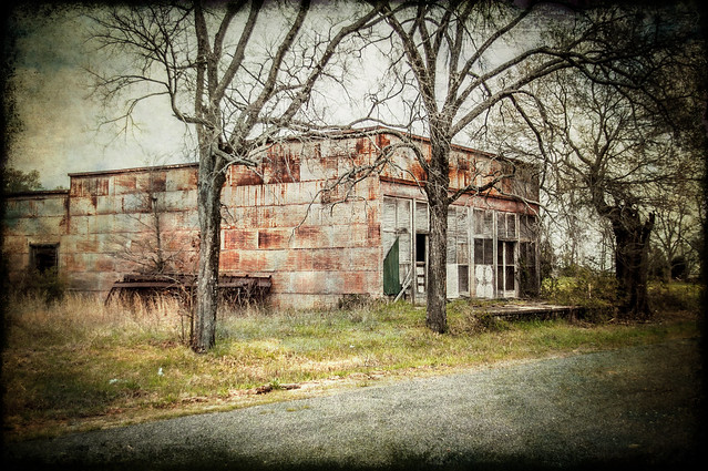
Andersonville was located at the confluence of the Seneca and Tugaloo Rivers, right where the Savannah forms. By all reports it was a sizable town with stores and industry. By the late 1800’s it was already almost gone, having missed out on getting a railroad routed through it. By all reports it was a beautiful location, and became a picnic spot for residents from both South Carolina and Georgia.
When Lake Hartwell was formed in 1959, most of Andersonville was flooded. All that remains is a two-mile island.

Research on the town was a bit tricky. Andersonville was also the name of an infamous Confederate prison in Georgia. Proximity and having the same name caused some confusion, but I was able to narrow search terms and get some good information on the town.
The next town is part of a collection of “European” sounding names.
Vienna
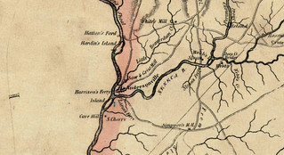
Vienna is similarly situated to Andersonville on the Savannah River, but in this case at the confluence of Broad River (Georgia) and Savannah. Vienna is on the east bank in South Carolina. Located just across the river are the towns of Lisbon south of the Broad, and St. Petersburg, north of the Broad.
Vienna was a lumber town, but was also the site of an exclusive academy founded by Dr. Moses Waddell. The academy eventually moved to nearby Willington. Lisbon, St. Petersburg, and Vienna suffered the same ultimate fate – transportation routes changed, and eventually the towns were inundated, this time by Clarks Hill Reservoir.

Pulaski
Pulaski Township was located upstream on the Tugaloo River. It was also a lumber town that relied on river traffic. Pulaski was near the old town of Madison, which is also on my list. On Robert Mills 1825 list it is shown as “Polaskie”.
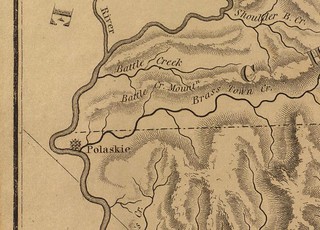
I’ve just gotten starting finding information on Pulaski. I haven’t even had a chance to pinpoint its location, but will be comparing the 1825 map to Google Earth and GNIS data soon.
The next town was also inundated, but on a totally different waterway.
Ferguson
Ferguson was another lumber town, but existed much later than the previous towns. It was active in the early 1900s, founded by B. F. Ferguson and Francis Beidler to process cypress trees from the Santee River area. Since it was a late arrival, it wouldn’t be on the Robert Mills maps.
When Lake Marion was flooded, it covered most of Ferguson. Some of the lumber mill is still visible on Ferguson Island at low water.

…and this brings us the last town on my list, which is a true enigma…
Mayucha
Mayucha is on just about every list I’ve seen of Ghost Towns in South Carolina. However, that’s about all I can find out about it. I don’t even know it’s exact location. The name doesn’t even show up in GNIS data.
All I know is that the town was about seven miles north of Tamassee in the Cheohee Valley. There is also a Maiuka Falls nearby, so there is a name variant. The name Mayucha shows up on a couple of lists of post offices until about 1910. Supposedly when the post office was closed the building was moved to the campus of the Tamassee DAR school.
I’ve been able to find the town on a couple of old maps…
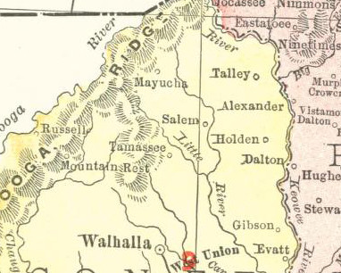
Apart from that, I can’t find anything. Even my graduate advisor, a long-time resident of that area, had never heard of Mayucha. There are old gold prospects in the area and a Davidian compound, which might be why the location is so guarded.
So that’s the list. Here’s a Google Map with those locations…
View Ghost Towns Update in a larger map
I’m hoping to get to some of these in the near future. Until then, I’ll keep doing research. If anyone has any other information about these towns, I’d love to hear about it. Just remember that I’ve probably hit most of the obvious Google-able resources.
Thank you for the time & effort you’ve put into your research. This is the most interesting thing I’ve read all weekend! 🙂
I’ve been to Mayucha many times I’ve been in about 20 mine shafts. I’ve found 2 smelts but all of the old structures are gone it’s amazing to see and I have many more trips planned to find as much as I can but the residents in the area are not very welcoming
I look forward to reading your updates after you visit these potential sites.
I know this is getting off the subject, but when I was a girl in the early 1960, we used to go to a place on Mineral Springs Road in Laurens that had a huge pool, supposedly fed by the springs and my Mom and Dad talked about going to dances there at a dance hall when they were teenagers.I can’t find anything on this. Can you help?
Crystal – I think I found the information you need about those springs. I was looking in the wrong place. Mineral Springs Road is in the Pea Ridge area of Laurens, just off of Fleming Street Extension. It’s near the that big pipe factory. I still don’t have any more info on it, though.
I know where it is a friend of mine owns it his name is Mike Simmons
It’s not a ghost town, maybe. But I grew up in Camp Croft in Spartanburg. There were many ruins (at the time) from the WWII facility. We used some near us as “forts,” and they were impressive. Some of the buildings were saved as a theater, church, industrial facilities, etc.. It was a cool place to grow up – almost like having an ancient city around you (though it was only the 40s, but the trees had made it look much older).
You know, I still have never been to Croft State Park. I may have to head over there during our winter break.
Cyrstal – I see the springs you mentioned in your comment on Google Maps, and I’m familiar with that area. However, I don’t remember a swimming pool or dance hall there. One of my older siblings might, though. A cursory internet search since your comment didn’t return much information, but I’m going to keep looking. You’ve got me intrigued now.
I know that Harris Springs was a mineral springs resort in lower Laurens County at one time.
Hello I live in Long Creek. I know the general area where Pulaski is. My old deed is to Pulaski township. There is a graveyard still back in those woods. I never check email. Feel free to call 864 723 3515
Hi Crystal,
I found a map at Oconee County Library in Walhalla, SC showing the town of Mayucha.
I drove by what I thought should be the location, according to the map, but only saw a private driveway leading to what could be the location of the town. I can E-mail you a copy of the map if you would like me to?
Dave Miller
West Union, SC
Would you please email me a copy of your map?
Thanks
Hey,
I have property in the area of Mayucha…. The property is near the State Owned Piedmont Forestry Center… I would be interested in learning more about Mayucha.
I am familiar with the wilderness there and frequently do “exploration” and “freestyle hiking” utilizing the deer trails in the area during January and February.
Email me a map, and any other info you might have, and I’ll start searching. I already know the location of a small “hillbilly-style” gold mining colony in the area.
Keep Up the Interesting Work,
Rick
Please could I have a copy of the map as well
Thanks
diaroberts0@gmail.com
I’d love a copy also
Tom, could you guide me, so to speak, using the Google image on the kingville article to about were you were when y’all saw the foundations and streets. I am familiar with the topography and griffins creek rd. Thanks. Hopkinsseafood@yahoo.com
I’ve pretty much narrowed down what I suspect is the location of Mayucha. By using the map provided above, and investigating local cemeteries, one can conclude that the reference “Tally” refers to a family of large property owners in the area… they are buried at the now defunct Whitmire Church grounds cemetery. The reference to “Alexander” refers to another large property owning family burried at the Alexander Cemetery. The name of postmaster at Mayucha was Thompson, who is buried at the Wolf Pitt cemetery. Using these 3 cemeteries, plus local knowledge of the topography and old road system, I’ve been able to narrow the focus to a small valley within Cheohee Valley. There is a lake there that shows on various maps as a “National Forest Lake” but is locally known as Lake Cheohee. The old-time hunters that I know locally, tell me there are several abandoned gold mines up in the hills of this little valley. The creek that runs through the valley, falling from Mayuka Falls, is often panned for gold.
These modern facts lead me to believe that Mayucha is under Lake Cheohee, which was once a bottomland creek and eventually flooded by the Alexander family long ago.
Using the trading post at Oconee Station in Tamassee as a start point, the distance to Lake Cheohee is 7.5 miles.
This winter, I intend to scout the hills for the mines.
Rick, I’d love to hear what you find. Keep me posted.
RE: Mayucha…. I’ve made quite a bit of progress pinpointing the location of this mining town.
I’ve been using various “ancestry” type resources, plus many old shipping guides, postal guides, Confederate pension records, geological studies, Native American archaeology studies, and other historical ‘print’ resources. I used these to compile a list of names of significant families and possible historical locations related to Mayucha.
Armed with this knowledge I assimilated into the valley culture, attended local church services and interviewed old timers on the family histories of Lay, Alexander, and Moody who are Mayucha’s prominent figures. I’ve accumulated old maps, hiked the various ridges and ravines using the deer trails with hunters as guides. I’ve visited the old defunct cemeteries, traveled to the mines, explored old roadbeds, and walked along the family-named creeks and waterfalls.
Using all the above, I plotted the significant GPS locations on a Google Earth image. The ‘pushpins’ create a tell-tale ring around a certain particular valley. The closer I investigate this beautiful valley, the more frequently I stumble upon clues leading to breakthrough information.
I still have plans for more definitive research, but in pursuit of this project I’ve come to realize that while I’ve been able to uncover many of the mysteries Mayucha, my joy was not in finding the answers but in the search for new questions to uncover it’s mystery.
If you are looking for an easy answer here, all I will tell you is that Mayucha is hiding in plain sight. The former inhabitants live today in the graveyards and place names recorded in it’s history. Seek and you will find it. Until then, I’m keeping it’s secrets so as not to deprive you of the pleasure of the hunt.
Meanwhile, if someone is interested in learning of my search, I plan to write an essay type document with maps and footnotes. My email is KeoweeLakeClub@gmail.com
Rick
I’m new to the area I’m from St. Louis mo where we don’t have a lot of history of towns gone lost so I’m very interested
I know where the mines are , remnants of the town, and a ceremonial Indian cave. Even the smelters from the mines.
Rob – 8647040323
I’ve been to Mayucha and I’ve been in about 20 of the old mines found a few of the old smelters all building are long gone but most of the property the town was on is privately owned it is not easily accessible . I’ve put in a lot of walking through the hills finding what is left but the only way to protect this area is to keep it secret. If you do happen to stumble across this area please keep it to yourself and enjoy the adventure of exploring and be careful entering tight spaces