Skip to content

Random Connections

A collection of photography and exploration focusing on Upstate South Carolina and beyond.

  • Home
  • About Us
  • Photos
  • Resources
  • Other Voices
  • Post Archives
  • Home
  • Geocaching and Maps
  • Telling Time in Google Earth, Part 2

Telling Time in Google Earth, Part 2

Posted on May 6, 2010 By Tom 1 Comment on Telling Time in Google Earth, Part 2
Geocaching and Maps, Science

North Pleasantburg

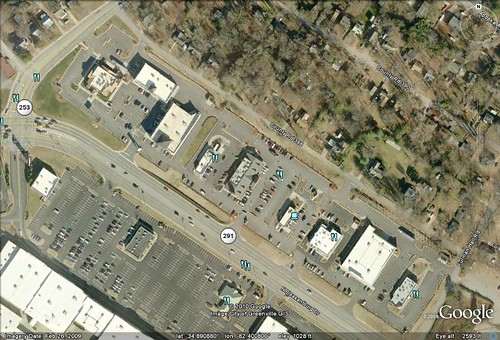
Yesterday I presented readers with a problem – Can you tell the approximate time of day an image was created in Google Earth? Using the image above of Cherrydale Shopping Center in Greenville, I pointed out some clues and some strategies for making a guess. Here’s another, sure-fire way of figuring out the problem…

First, visit the website for the Royal Observatory at Greenwich, England. They’ve got an excellent tutorial on how to create your own sundial. However, what you’re really after is the sundial template JPG, which I have posted below…

Sundial

What you need is the URL to that image, which I’ve conveniently pasted below:

http://www.nmm.ac.uk/upload/img/sundial_template_dial.jpg

The next step is to open Google Earth and zoom in fairly close to your target area. Make sure that you have north at the top of the screen. Pick out a nice, clear shadow, preferably one made by something tall and skinny like a pole or sign. Click on the Add Image Overlay button. In the box next to “Browse” paste the URL for the sundial image.

Once the sundial image appears, set the opacity of the image about halfway so that you can see the sundial, but can also see what’s on the map underneath. Position the image so that the lines of the sundial converge on the shadow you selected. You should then be able to read the time of day on the sundial. This will tell you when the image was captured.

sundial

As shown in the illustration above, this particular image was captured at about 9:00 am.

This is also fun to try with large landmarks, such as the CN Tower in Toronto, Canada, the Eiffel Tower, the Burj Dubai, and other tall structures.

Once you have looked at several structures from around the world, look back at the length of the shadows. Does latitude have an effect on the length of the shadow? There’s lots of science you can work into this lesson.

UPDATE: As I think about this, I doubt it would work for the southern hemisphere. I think you would have to create a graphic that points south. You can’t just rotate the existing image. You would need to do a horizontal flip.

Tags: activities edtech Google Earth lesson plans

Post navigation

❮ Previous Post: Does Anyone Really Know What Time It Is?
Next Post: Looking for Fossils on Lady Island ❯

One thought on “Telling Time in Google Earth, Part 2”

  1. Pingback: Blog Report: Google Earth Time, Spring Fling Photography, A Funny Non-Sequitur, And Blowing Deadlines | Spartanburg Spark

Leave a Reply Cancel reply

Your email address will not be published. Required fields are marked *

This site uses Akismet to reduce spam. Learn how your comment data is processed.

Categories

  • EdTech (200)
  • Entertainment (201)
  • Family (120)
  • Gear (115)
  • General Technology (99)
  • Geocaching and Maps (208)
  • History and Genealogy (260)
  • Internet (144)
  • Local (449)
  • Miscellaneous (544)
  • Music (194)
  • Paddling (245)
  • Photography (779)
  • Podcast (6)
  • Rambling (226)
  • Rants (160)
  • Recipes (34)
  • Religion (48)
  • Restaurants (165)
  • Science (48)
  • Things Overheard (29)
  • Travel (410)
  • Uncategorized (129)
  • Washington Sabbatical (113)
  • Weirdness (60)

Recent Posts

  • Wilkinsville and a Mystery Church
  • A Farewell to the Greenville Chorale
  • Edisto River from Good Hope to Sullivan’s Landing
  • Paddling Lake Monticello
  • The Remnants of the City

Recent Comments

  • Darrell Erskine on Mysterious Mayucha and The Wolf Pit
  • Hutch on Exploring Southern Fairfield County – Part 1, Old Lebanon Church
  • Nancy on About Us
  • Steve Rushton on Mysterious Mayucha and The Wolf Pit
  • Tom on Finding Irish Music in South Carolina

Tags

blogging cemetery Christmas Columbia Edisto River edtech Entertainment family Flickr Florida Furman Furman University gear Georgia geotagging Ghost Town Ghost Towns Google Earth Google Maps GPS Greenville Greenville Chorale history Instructional Technology kayaking Lake Jocassee LCU Lowcountry Unfiltered maps Music North Carolina Paddling Photography rambling restaurant Restaurants review singing social networking South Carolina time-lapse Travel video Washington Washington State
June 2022
S M T W T F S
 1234
567891011
12131415161718
19202122232425
2627282930  
« May    

Copyright © 2022 Random Connections.

Theme: Oceanly by ScriptsTown