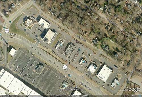
Yesterday I presented readers with a problem – Can you tell the approximate time of day an image was created in Google Earth? Using the image above of Cherrydale Shopping Center in Greenville, I pointed out some clues and some strategies for making a guess. Here’s another, sure-fire way of figuring out the problem…
Tag: lesson plans
Here’s an interesting activity you can do with students using Google Earth. It helps if you use the actual program (or the satellite view in Google Maps) instead of a static image so that students can zoom in and out…
The above Google Earth image is of the Cherrydale Shopping Center in Greenville. Using only clues from the image, can you tell me the following:
- About what time of day was the image captured?
- What month was the image captured?
Good luck!
I had wanted to entitle this post “Cool Google Earth Lesson Plans That Don’t Really Use Google Earth”, but I figure that would be a bit wordy. The idea was taken from my “Creating Media Rich Lessons with Google Earth” presentations that I’ve been doing lately. One of the strategies in that presentation is to embed content from other sources into Google Earth. As I was giving some examples to the workshop participants, it occurred to me that you could do a collaborative project in Google Earth where kids do most of their work in some other application, bringing these together at the last minute in Google Earth. Here are a few of those ideas, and the applications needed.

