Skip to content

Random Connections

A collection of photography and exploration focusing on Upstate South Carolina and beyond.

  • Home
  • About Us
  • Photos
  • Resources
  • Other Voices
  • Post Archives
  • Home
  • Geocaching and Maps
  • New Google Earth Imagery

New Google Earth Imagery

Posted on October 8, 2006 By Tom No Comments on New Google Earth Imagery
Geocaching and Maps

While preparing for my talk at EdTech last week I stumbled across an announcement that Google Earth was releasing a huge new batch of images on October 3.  During the talk I got a glimpse of these images, but was unable to explore them fully until I had a chance to sit down on a lazy Sunday morning.

It now appears that all of South Carolina is available in higher (not the highest) resolution.  I did a spot check of places around the state, and this does appear to be the case.  I hit some of my genealogy sites that I knew to be in low res previously, and they were much clearer, as was all of my school district.

North Carolina doesn’t seem to have received as many updates.  The images dropped to low res when I crossed the state line.  Then again, I haven’t had a chance to check out most of that state.  Georgia seems to have fared better.  I was able to find Houston’s house on Black Ike Road.  While the picture of the AREA around his house is clearer, the house itself is more obscured by vegetation.  I have absolutely no doubt that he planned it that way.

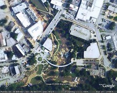
Most of the images are fairly recent.  New construction along the Reedy River is visible and seems to be up do date.  However, construction on the new schools in our district isn’t visible.  I’m guessing most of the updates are two years old, for the oldest of them.  That’s not too bad.

The image below is of the Reedy Falls area of Greenville…

technorati tags:Google Earth

Post navigation

❮ Previous Post: Failing NCLB
Next Post: Updated Instructional Technology Diagram ❯

Leave a Reply Cancel reply

Your email address will not be published. Required fields are marked *

This site uses Akismet to reduce spam. Learn how your comment data is processed.

Categories

  • EdTech (200)
  • Entertainment (201)
  • Family (120)
  • Gear (115)
  • General Technology (99)
  • Geocaching and Maps (208)
  • History and Genealogy (260)
  • Internet (144)
  • Local (449)
  • Miscellaneous (544)
  • Music (194)
  • Paddling (245)
  • Photography (779)
  • Podcast (6)
  • Rambling (226)
  • Rants (160)
  • Recipes (34)
  • Religion (48)
  • Restaurants (165)
  • Science (48)
  • Things Overheard (29)
  • Travel (410)
  • Uncategorized (129)
  • Washington Sabbatical (113)
  • Weirdness (60)

Recent Posts

  • Wilkinsville and a Mystery Church
  • A Farewell to the Greenville Chorale
  • Edisto River from Good Hope to Sullivan’s Landing
  • Paddling Lake Monticello
  • The Remnants of the City

Recent Comments

  • Nancy on About Us
  • Steve Rushton on Mysterious Mayucha and The Wolf Pit
  • Tom on Finding Irish Music in South Carolina
  • Rachel B on Finding Irish Music in South Carolina
  • Kim Atchley on Journey to Nazareth

Tags

blogging cemetery Christmas Columbia Edisto River edtech Entertainment family Flickr Florida Furman Furman University gear Georgia geotagging Ghost Town Ghost Towns Google Earth Google Maps GPS Greenville Greenville Chorale history Instructional Technology kayaking Lake Jocassee LCU Lowcountry Unfiltered maps Music North Carolina Paddling Photography rambling restaurant Restaurants review singing social networking South Carolina time-lapse Travel video Washington Washington State
June 2022
S M T W T F S
 1234
567891011
12131415161718
19202122232425
2627282930  
« May    

Copyright © 2022 Random Connections.

Theme: Oceanly by ScriptsTown