I’m not one of those people that mounts protests every time Facebook changes their layout, or when GMail makes some slight change. I even like the new updates to Flickr, even though some users are threatening to abandon it for Ipernity. So, when I say that Google Maps has really screwed up with their latest updates, I really mean it.
Initially the update looked promising, so I signed up for the Beta version. The 3D views and integration with Google Earth look very slick. However, right away I started to seeing some problems. The “My Places” section was hidden – de-emphasized as if Google may be doing away with it. When you click on the map you get links to (surprise, surprise) businesses with potential advertising. For users like me, I now had several steps instead of one or two to get to what I wanted, and it looked like one of my primary tools was being threatened.
However, the real clincher came as I was trying to geotag some photos from my last paddling trip to Lake Marion. For this past trip I had photos from three cameras – GoPro, Panasonic Lumix LX-5, and a Fuji WP33. I had GPS tracks from a Garmin Venture HC and an iGotU 120 tracker. I use the GPSPhotoLinker software on my Mac to match the photos with the GPS tracks.
I can check individual photos by clicking on “Show on map” in GPSPhotoLinker. By default, this brings up a Google Map with the latitude/longitude coordinates for the photo. If it’s not where I expect it to be, I can tweak either the timing or some other variable to get it where I want it.
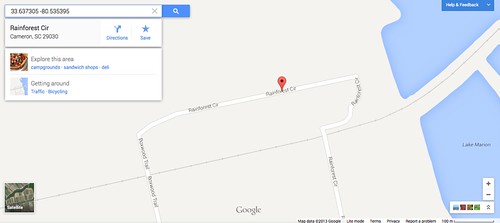
Unfortunately, this morning I couldn’t get any of my photos to show up correctly on Google Maps. I assumed that the either the GPS clock or the internal camera clock must be off. However, it didn’t matter which camera or which GPS track, the photos showed up on the same road as shown below:
After an hour and a half of trying to get this to work (and even downloading a trial version of a new geocoding program), it dawned on me to try something else. I started by popping the photos into Lightroom and using the mapping program there to check geocoding. Using the same images and GPS tracks, it showed the photos where they are supposed to be. However, the Lightroom geotagging function is useless because it doesn’t write the location data to the image’s EXIF data when the picture is exported.
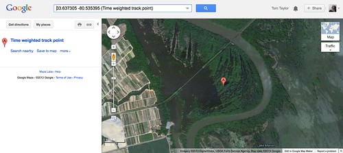
Since the images and GPS tracks seemed to be synced OK, I decided to try something else. I went back to GPSPhotoLinker and set the default so that it would display on MapQuest instead of Google Maps. Worked like a charm. Now my images were showing up where they were supposed to be. Since that worked I decided to switch back to the Google Maps “Classic View” for the default view, and that cleared up the problem. The images appeared once again were geocoded correctly, in the middle of the lake instead of a lakeside neighborhood.
As far as I can tell, what the new version of Google Maps is doing is when a set of coordinates is input into the service, it returns the location for the nearest street address – always. That doesn’t help if your coordinates are in the middle of a lake, or if you’re hiking in the middle of nowhere. it seems that Google Maps is now only useful for people driving or people on streets. I can’t find anywhere to turn off that “feature.”
So, Google, if you’re truly wanting feedback about your beta product, you need to make your maps once again useful to those of us that tend to stray off of the roads.
Thus endeth the rant. Selah.
Same problems, plus the more i enlarge the map the smaller the text gets to the point of totally disappearing. Also, I can no longer get Google maps to print out a portable copy to take along on my journey.
What is Google trying to do to what was such a good tool. In fact, most companies can’t seem ever to leave well enough alone. Do they ever contact users to see if they want the changes, or are they the owner, arrogantly poised to cram it down your throat, so long as it bring in a few more advertising dollars?