Back in 2007 I wrote an post entitled “Geopodcasting – Adding Location to Audio.” I had just given a talk at SC EdTech on geotagging, and the post was meant to explore the idea of geotagging audio files.
There have been lots of changes in the seven and a half years since that post came out. I wanted to revisit the subject and see what tools and options are now available for for adding location data to audio.
Back in 2007 photo geotagging was just taking off. It was (and still is, to some extent) a tricky process. Back then smart phones weren’t as prevalent, so not too many people had a hand-held device that could combine GPS, imagery, and audio. Today we have iPhones, Androids, and various tablets that can do all of this. So you would think that the process would be much easier. But is it?
First, a bit of technical information…
Digital photographs have what’s called EXIF data attached to each file. This metadata contains information about the camera, exposure, whether or not the flash fired on the camera, and lots of other information about that specific photograph. EXIF has fields for latitude and longitude, so the location data can be written directly into the file.
Audio files have something similar. ID3 tags contain information that is more musically oriented rather than technically oriented, as the EXIF data is. This includes fields for the artist, album, track title, track position, etc. Unfortunately, there are no fields for location data, so that information can’t be written directly to the file. Geographical information must be kept separately, and this is where the problem arises. It’s possible to add location data to comments and tags, but a third party service is required to match up all this location data for audio files.
It seems like it should be a simple fix – just add fields for latitude and longitude as there are in EXIF data. But, it’s not quite that easy…
A photograph represents a fixed point in time. Therefore, it can be pinned to a specific location. Audio (and video) represent a duration of time, and location can change during that time. What location data do you include? Where the file begins? Where it ends? I would suggest the former, but there isn’t a consensus as there is with image files.
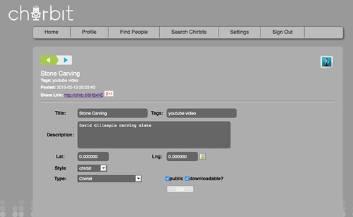
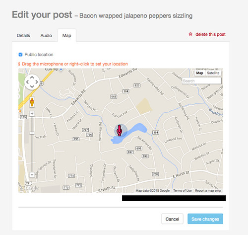
Even so, there have been some advances in adding location data to audio. There are now several excellent online audio hosting services. At least two of these allow users to place their files on a map. Audioboom.com (formerly audioboo.fm) and chirbit.com are two I use frequently. Both of these services have mobile apps, but neither lets you include location data. That has to be added on the site itself after the file has been uploaded. Sadly, the most popular service, Soundcloud.com, has not implemented geographic services, but you could add location data in the tags for your files.
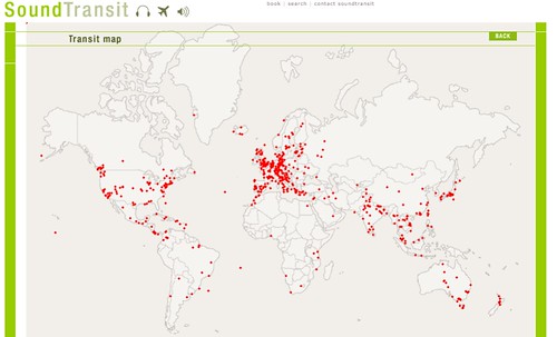
I’ve found two websites that focus on audio mapping. Soundtransit has a searchable site that lets you select a location, then displays sound files associated with that location. There is a map of sounds, but it’s not very interactive. You can click on a marker for a sound, but you can’t zoom into the map.
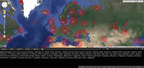
The next site has a bit more promise. Aporee is a location-based service that works in conjunction with Internet powerhouse Archive.org. The sound clips are uploaded to Archive, then tagged with the appropriate Aporee data. There is an interactive map which functions much, much better than Soundtransit’s map. Radio Aporee is a stream of random ambient sounds from around the world.
In the time since I wrote that first post we have a whole new batch of tools through smart phones. I’ve come across four apps for iPhone that look like they would do the job. It looks like these also have hosting sites associated with them. You would have to have your own hosting so that you can match up the audio with the geographic information.
iFieldRec is pretty straightforward. You’re given a recording screeen overlaid onto a map.

Other interesting apps are Recho and Shoudio, both catering to geography-based audio. AudioPortation takes a different tact. Users also take a photo to associate with the audio file.

AudioPortation also allows users to add notes, and gets closer to becoming an all-around multimedia field notebook. I think a future blog post will feature those types of apps.
So, geopodcasting isn’t quite a thing yet, but there is interest and improvements in the field. Even if an app or service doesn’t have a specific place to record location, you can always tag it with either keywords or hashtags.
I really like the “take sound” button.