
So far the day’s photo trek across Cherokee County had been a mixed bag. We had found an old concrete airway beacon near Reidville, which was cool. We found a cool old chapel near Pacolet. But we had encountered No Trespassing signs just about everywhere else we tried to go in Cherokee County, and had a sub-mediocre lunch at an over-hyped joint in Gaffney. It was time to see if things would turn around.
On the way into town Tommy Thompson and I had noted the location of the Cherokee County Historical Society. After lunch I wanted to stop by to see if we could get any information on the Cooperville location, so we headed back that way. The entrance wasn’t readily apparent, but we think we found the right location and pulled in. More discouragement. First, there was a sign saying there was a $5 charge to enter, then…the door was locked. We’d had enough frustrations for one day, so we left.
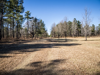
Our morning route had been across the southern parts of Spartanburg and Cherokee. The route home was along highway 11, across the northern parts of those counties. It was still cool out, and the air was crisp and clear. We could see lots of steam rising from the power plant up near Cliffside across the state line. We came to the Cowpens Battlefield, and decided to pull in. Surely there would be no locked doors or no trespassing signs here. That was partially correct.
It’s been a VERY long time since I’d been to the Cowpens Battlefield. To give you an idea, the visitor’s center was constructed in 1980, and I don’t remember it at all. Tommy had never been there.

There were a few cars here, even on this cold day. Upon entering we were waylaid by an overeager ranger. Rather than just let us browse, he insisted that we watch the 20 minute introductory video. We did. It was interesting enough, describing General Daniel Morgan’s defeat of a larger British force led by Banestre Tarlington. After the video, the ranger insisted that we view another 15 minute presentation using maps and LEDs. Again, interesting. As it turns out, these were the only two public displays in the visitor’s center. There weren’t many artifacts or other displays of interest.
Tommy and I decided to walk out onto the battlefield. However, before we could even get out onto the trail the overeager ranger waylaid us again, regaling us more details about the grounds than we really wanted to hear just then. We finally broke free and walked out along the trail.
We made it as far as the main encampment along the old Green River Mountain road. It was just too dang cold and breezy for much of a hike, and we were already tired. We headed on back in.
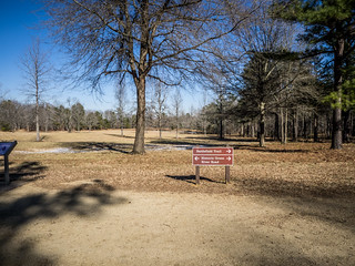
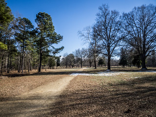

There is a historic loop driving route, but it was closed off because of icy conditions. Figures, given the way the day had been going.
From Cowpens we crossed into Spartanburg County. We drove through Chesnee, then to peach Mecca of Cooley Springs. The entire area is covered in peach trees, and despite the cold and recent snow, some looked on the verge of blooming. I hope that’s a mistaken observation on my part. We circled through the community, but didn’t take photos.
Next up was Fingerville. An old mill sits on the banks of the Pacolet River. Mill village houses lined a couple of streets on either side of the river. We drove through the area looking for a route down to the the mill or the river or both, but didn’t find one. The one street on the other side of the river circled a high prominence that looked like the perfect place for a school or community building no longer extant. State archives indicate a large two-story building once served as a school. Google Earth shows ruins there on the prominence, but the GNIS data doesn’t show where the school might have been.

We continued on across Spartanburg and into Greenville County. Tommy had never been to Campbell Covered Bridge, so we decided to stop. Even though I’ve photographed this bridge hundreds of times, I liked the way the light was playing over the remnants of snow. I had to take some more photos.
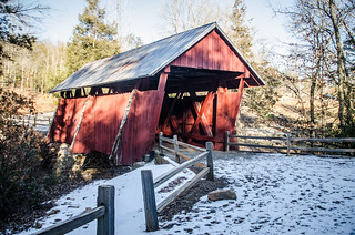
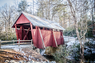
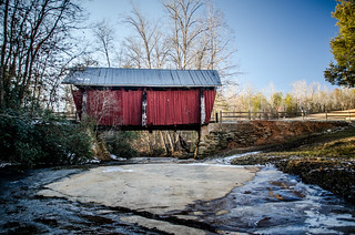
Before the Greenville Recreational Department did such a fantastic job redeveloping this area as a park, there were some remnants of the old grist mill just below the bridge. Now nothing is left but the foundations of the mill and the Smith home place just above the mill.
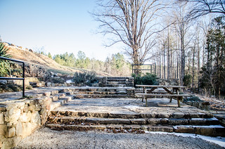
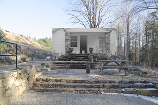
The Rec Dept has added so nice signs that describe the homeplace, and even have a photo of the old white frame house that once stood here.

I took a close-up of the house in the lower left corner of the sign above, and used that to create a composite shot showing the house within the present-day context. It was actually quite easy to match up the steps in both photos.
Tommy and I continued on over to North Greenville University and took a turn through the campus, then headed on home. It wasn’t one of our most successful photo outings, but we had seen some interesting things, and it was great to be out and about.