Memorial Day Weekend is always the pits, at least as far as Furman is concerned. This weekend is particularly bad. Laura has to give exams both Saturday morning and Monday morning. When she’s not giving the tests, she will be busy grading them. With Furman going onto a semester system next year, this is the last time that Memorial Day will be messed up.
Even knowing that she wouldn’t be available for exploration, I got my household chores done ahead of time this week during the evenings so that I could head out and explore this weekend. I had planned to do a bit of geocaching, but I put that on hold to take a few photos.
My first target was Freedom Weekend Aloft. Last year I stumbled onto a balloon launch from a parking lot and was able to get some great shots. I was hoping for the same this year, but I was afraid the brisk winds this morning would keep the balloons grounded. Either my fears were confirmed, or I had missed the schedule. There were no balloons to be seen. Therefore, I headed north to look for some waterfalls.
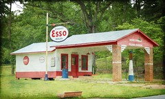
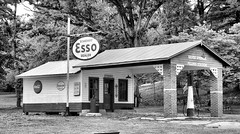
One evening after dinner a couple of weeks ago we had taken the convertible on the Saluda-Tryon loop. I’d spotted a couple of interesting things to shoot, so I wanted to retrace those steps. From Simpsonville I headed straight up Highway 14 through Greer an on to Tryon. I pause to take a couple of shots of an old restored Esso station just outside of town.
I took a few minutes to explore Tryon. I drove through some of the towns side streets, which were twisty, turny affairs that clung to the sides of the mountains. I came across one street named Hogback Mountain Road, and began to ponder. Twenty-some years ago, before Jim Anthony’s Cliff’s development made most of Glassy Mountain off-limits, Bob Donnan and I explored this area quite a bit. There was a dirt road that connected Glassy, Hogback Mountain, and Tryon, and I wondered if I had just found it.
As I twisted up the mountain, the GPS indicated I was headed in the right direction. There were some spectacular views of the Piedmont off to the south, but an incoming front made lighting conditions difficult for photography. I got to a place where the pavement ended, and there was a pull-off to one side. The paved road continued onto the right into a gated community.
I parked the car, got out, and started taking a few shots of the view. As I did a woman in an SUV had driven down to check her mail. She told me that the view from her back deck was even more spectacular, and that I was welcome to come take pictures. This took me aback. Here I was a complete stranger, and this woman is inviting me back for coffee and photography. For all I knew she might have had a a crazy armed husband, to brawny teenage boys, and a couple of pit bulls, and therefore felt safe in offering the invitation. However, I politely declined, stating that I had other stops I wanted to make while the lighting conditions were right (which they weren’t.)
I continued on up the mountain and got to a point where the road was barred by a gate with multiple padlocks. I guess this guy was serious about keeping people out. Thus thwarted, I drove on back down the mountain.
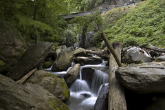
From Tryon I headed west on Highway 176. At one point it goes through a deep gorge and the road crosses the Pacolet River twice. I found a pull-out and hiked down to the river, pausing to take a few photos.
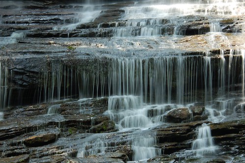
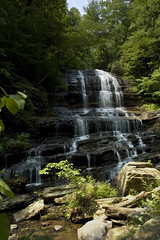
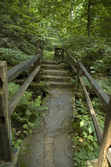
I continued up 176 until I got to Pearson Falls Road, and turned toward the falls. The falls area was certainly busier than the last time I was here, but not too bad. I hiked up and took a few shots. These falls are particularly hard to capture because the top part tends to get blown out, while the bottom is underexposed. The shot below is an amalgam of two images with different exposures, trying to compensate for this problem. I’ve also got one of the shots I took along the trail.
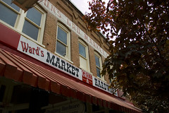
It was getting to be lunch time, so I headed on into Saluda. I had a quick lunch at Ward’s Market, which is one of two general stores in town. I took a few shots on the main street of town.
That pretty much wrapped up my successful photography for the day, but not my exploring. From Saluda I drove up to the Green to see how the river was running. To my dismay, I found that cyclists had discovered the twisting road into the Green River Gorge. That is NOT the place to encounter lots of bicycles. At the river itself, apparently the turbines weren’t running, so the water was down. There were only one or two groups on tubes. There was no way a kayak could have made it.
From the Green I continued northward and found myself at Lake Lure. The place was a madhouse. In addition to a festival, there was the added holiday traffic. I had thought about even driving on up to Chimney Rock Park, but it was equally nightmarish. Hickory Nut Gorge, Chimney Rock, and Lake Lure are beautiful natural areas, but there is some much redneck trash commerce in the area that it almost ruins the area’s appeal. I left without taking pictures.
By this time I was getting tired of exploring . I took Highway 64 back through Bat Cave and on into Hendersonville, then headed down the mountain toward home.
The waterfall exposure problem you mention with Pearson’s Falls is all too common. I just had a thought about that, though. Some new cameras have a feature that is supposed to adjust exposure somehow for backlighting. I don’t know if it’s the equivilant of the “equalize” adjustment in Photoshop, but the feature is billed as bringing out foreground detail without wiping out the background with over-exposure (if I understand correctly). My thought: I wonder what th effect would be of using this setting on a waterfall with mixed lighting (shadow low and full light up high). I don’t think the feature uses fill flash; it’s apparently a processing routine in the camera.
thanks for the descriptive writing about your trip. Looks like some interesting spots for me to add to my list.