Having gorged ourselves on a gourmet breakfast, we packed up cameras and maps and set off in search of coastline and lighthouses. There was just one small hitch – the wind was howling and it was dumping rain. We may have lost our minds to be going out in weather like this, but hanging around the B&B surrounded by creepy Gothic decor would have been just as bad.
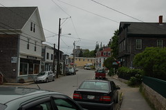
We started our trek with a turn through the town of Belfast. We had only explored on foot last night. It looks as if there is lots to see and do, including a footbridge across the Penobscot, and a higher walkway along the US 1 bridge. We may have to spend more time exploring this area.
The rain kept kept a steady pace as we headed north on US 1 through Searsport. I wanted to stop and photograph all the interesting old farm houses and churches. If we had done that we would have never made it out of town. There’s just much more interesting architecture here.
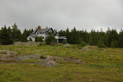
Our first stop was Fort Point near the town of Stockton Springs. There was a state park with access to the water, the remains of an old fort, a lighthouse, and an old bell tower. Laura stayed in the car, but I walked on out into the rain so that I would have at least one lighthouse photo to show for the day.
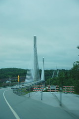
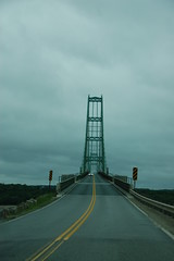
Back on the main road we soon reached the Penobscot Narrows Bridge. This is a relatively recent suspension bridge with the old bridge still running along side, unused. In the western tower they have built an observatory at the top, with elevator access. On a clearer day I’d really like to visit this and get some photos.
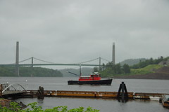
On the other side of the river we crossed into Bucksport and drove through the scenic little town. Here we debated our next course of action. We could continue our original plan southward toward the coast, or we could head north along the Penobscot River toward Bangor to search for moose. We decided for the original plan. The moose would have to wait. So, we turned off of the main highway at the community of Orlando and headed out toward the many peninsulas along the coast.
I had brought along a DeLorme topo atlas of Maine that I had picked up on our last trip up here many years ago. The scale on the map is quite large, so we found ourselves covering what looked like large distances in relatively short order. The main thing that slowed us down were the numerous little communities with slower speed limits and the deplorable condition of the roads. It was impossible to take any photos from a moving vehicle under these conditions.
We soon reached the town of Castine. The town is home to the Maine Maritime Academy, and is also the site of several skirmishes during the War of 1812. Apparently the British had occupied several forts an encampments along this cape, and there were signs all around town describing various historical events.
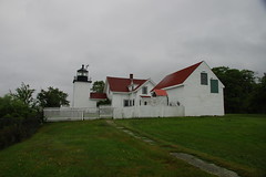
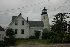
We soon found our second lighthouse – Dice (Dyce) Head Light – which turned out to be a private residence. I got some shots from the street, but the power lines were a bit of a distraction.
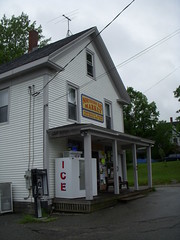
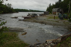
From Castine we headed northwest, then rounded the northern bay of the Bagaduce River. In the town of Penobscot we drove down to the water access, where a small waterfall was cascading into the bay. Around the corner we stopped at a little general store for some snacks to hold us until lunch. Even here there was a large tank full of live lobsters.

We stopped briefly at Bagaduce Falls. There are several of these “reversing falls” in the area. These aren’t really waterfalls as we think of them in our area, but are narrow sections where the extreme changes in tides create rapids first going one way, then the other depending on whether the tide is coming in or going out.
A sign for a wildlife preserve caught our eye, so we decided to follow it. This led us out onto the remote Cape Rosier, just south and across the Bagaduce from where we had been in Castine. The road around the cape was mostly dirt, and seemed to be in better condition than the paved roads we had previously encountered. Here we found another set of reversing falls – Goose Falls.
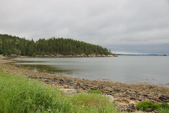
Continuing around the cape, we paused briefly at the rocky beach at Orr Cove. We were also beginning to see lots of large rock outcrops. We were later to learn that this was a glacial feature, and these boulders and outcrops could be found throughout the area.
We made our way back to the mainland (or as mainland as you can get in this area), then continued southward. We crossed the Eggemoggin Reach over to Little Deer Island on a large, narrow suspension bridge that had been narrowed to one lane because of painting.
From Little Deer we crossed over to Deer Island, and into the town of the same name. By this time our huge breakfast and our snacks had finally worn off, and we were ready for a late lunch. We found a neat little cafe just outside of Stonington where we had some excellent sandwiches, then continued on our way.
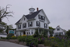
The town of Stonington is a picturesque Maine fishing village. There is lots of Victorian architecture, and we saw tons of lobster pots. No guessing about the main industry around here! We first drove through the town and began searching for two more lighthouses – Walker Point and Deer Island – but struck out on both points.
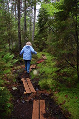
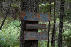
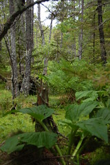
We continued on outside of town toward the Crockett Cove Preserve. This is a natural area consisting of spruce forest and bogs, and is run by the Nature Conservancy. We hiked along the trails for a bit until the mosquitoes and general bogginess got to be a bit much.
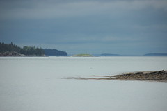
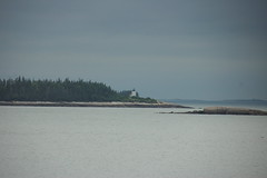
As we drove back into Stonington we rounded a bend and finally got a good view of the Deer Island Lighthouse, off the coast about a half-mile away.
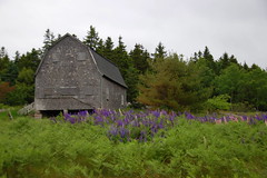
We drove back into town and decided to explore on foot for a bit. We learned that we had just missed the annual Lupine Festival. The lupine had been in full bloom all along our route today, and was just spectacular at any unmowed roadside area.

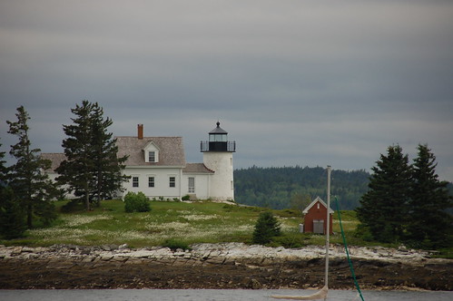
By this time we were getting very tired, so we decided to meander back. When we reached Little Deer Island, however, we had one more stop to make. We passed the bridge and drove north to the community of Eggemoggin, were we were treated to views of the Pumpkin Island Lighthouse.

By the time we got back to Belfast we had missed our sherry and cheese social. We walked from the inn down to the main part of town were we found Darby’s, a local pub with a VERY eclectic menu. Not only could you get traditional Maine fare, but enchiladas, Pad Thai, curry, hamburgers, and steaks. Laura got the curry, and I had New England Clam Chowder and an enchilada, all washed down with a gin martini. It was a nice end to a day of exploration.
The first image (a lighthouse) and some others suggest (of course) Andrew Wyeth paintings. Which brings to mind a question: if a photo could be a “Wyeth,” what would it look like, and how would you get it there? Within the realm of the photo, of course. Much like, in the Allen electronic organ world, the thought is not “that is a harpsicord sound,” but rather “what would a harpsicord sound like if it were an organ stop/setting?” Can a photo be edited to capture even further the essence of “Wyeth” and be a photo?
I’ll have to wait until I’m back home on a computer with Photoshop before I can find out.
some excellent pictures…
I am heading up through Maine in a couple of weeks to Canada and I plan to spend a couple of days in Freeport and search out a few lighthouses to take some pics of.
I hope to do it without the rain though…
you wont find lighthouses near to Freeport. Portland has two good ones. If you go to Boothbay and board a local ferry you can see a good lighthouse in that area. At Math Maine and the famed Kennebec River there are some great lighthouse to find
off hard to find trails–but the effort is worth it.