Skip to content

Random Connections

A collection of photography and exploration focusing on Upstate South Carolina and beyond.

  • Home
  • About Us
  • Photos
  • Resources
  • Other Voices
  • Post Archives
  • Home
  • Newberry County

Tag: Newberry County

Seeking Jalapa

Posted on April 7, 2026April 7, 2026 By Tom No Comments on Seeking Jalapa
History and Genealogy, Rambling

It’s one of those blink-and-you’ll-miss-it communities. There are signs for Jalapa on I-26, but unless you know where it is you’ll drive right through and never know you’ve been there. I’ve known about Jalapa for most of my life. My family has a long history both in Newberry and in Laurens, so we’ve passed through … Read More “Seeking Jalapa” »

Two Rivers for the Price of One

Posted on October 11, 2009 By Tom No Comments on Two Rivers for the Price of One
Paddling

Starting Out on the Enoree

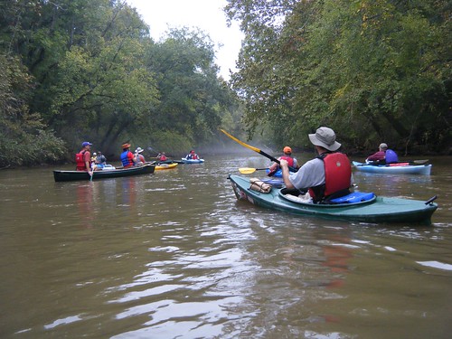
This time our Lowcountry Unfiltered group got two rivers for the price of one, plus a few ghosts and goblins thrown in for good measure. On Saturday we paddled a portion of the Enoree River to its confluence with the Broad River, then down to our take-out at Strother’s Landing.

Planning this trip proved to be a challenge. The group wanted to paddle an Upstate river, but didn’t have the boats for whitewater. There was also the matter of distance. These guys would be driving for 3-4 hours just to get here, so the paddling trip couldn’t be too long. If they’re driving that far, then the trip needs to be worthwhile, and not a drag through the mud.

My first plan was to paddle a stretch of the Tyger River. It had all the elements I needed – it was remote, full of history, and even a ghost story. Unfortunately, there wasn’t much water when Bob and I paddled it last month. It was more of a muddy hike while dragging boats.

Fortunately, I was able to find a suitable route. We would put in at Keitt’s Bridge on the Enoree near Maybinton and float to its confluence with the Broad River, then paddle down to Strother’s Landing at the Highway 34 Bridge. According to Google Earth, the route would be about 7 miles. This route takes us through Sumter National Forest, so it’s suitable remote, and there’s even a ghost story – The Hound of Goshen.
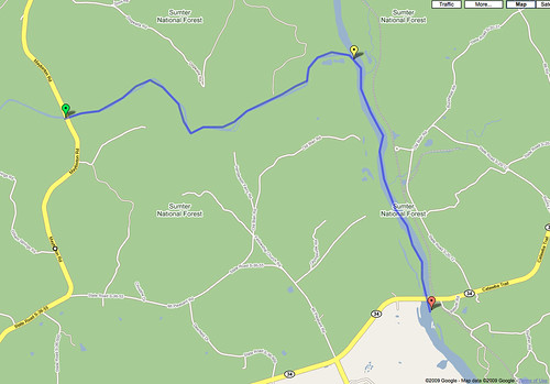
Enore_Broad_River_Map

Read More “Two Rivers for the Price of One” »

Categories

  • EdTech (197)
  • Entertainment (202)
  • Family (124)
  • Gear (114)
  • General Technology (98)
  • Geocaching and Maps (208)
  • History and Genealogy (279)
  • Internet (142)
  • Local (463)
  • Miscellaneous (562)
  • Music (206)
  • Paddling (271)
  • Photography (782)
  • Podcast (32)
  • Rambling (235)
  • Rants (163)
  • Recipes (40)
  • Religion (48)
  • Restaurants (165)
  • Science (48)
  • Things Overheard (29)
  • Travel (415)
  • Uncategorized (145)
  • Washington Sabbatical (113)
  • Weirdness (63)

Recent Posts

  • The Soviet Republic of Washington
  • Carolina Ghost Towns – Lost Cove, NC
  • Tom’s Smoked Fish Dip
  • Breakfast, Brats, Beer, and Bad Decisions – LCU Back on the Water
  • Heading Back to Ferguson in 2026

Recent Comments

  • Marilyn on The Soviet Republic of Washington
  • Rhonda Nelson on October Weekday Rambles – Part Two
  • Tom on Carolina Ghost Towns – Shelton, SC
  • Joanne Cromer on Carolina Ghost Towns – Shelton, SC
  • Lee Warren on Resources

Tags

blogging cemetery Christmas Columbia Edisto River edtech Entertainment family Flickr Florida Furman Furman University gear Georgia geotagging Ghost Town Ghost Towns Google Earth Google Maps GPS Greenville Greenville Chorale history Instructional Technology kayaking Lake Jocassee LCU Lowcountry Unfiltered maps Music North Carolina Paddling Photography rambling restaurant Restaurants review singing social networking South Carolina time-lapse Travel video Washington Washington State
September 2026
S M T W T F S
 12345
6789101112
13141516171819
20212223242526
27282930  
« Jul    

Copyright © 2026 Random Connections.

Theme: Oceanly by ScriptsTown