Skip to content

Random Connections

A collection of photography and exploration focusing on Upstate South Carolina and beyond.

  • Home
  • About Us
  • Photos
  • Resources
  • Other Voices
  • Post Archives
  • Podcast
  • Home
  • maps
  • Page 2

Tag: maps

GNIS Dilemma

Posted on June 6, 2011 By Tom No Comments on GNIS Dilemma
Geocaching and Maps, Internet

The Geographic Names Information System(GNIS) is one of the greatest boons to those of us who love maps. It’s an extensive database of place names created by the US Geological Survey, and includes cities, towns, communities, crossroads, schools, churches, mountains, rivers, etc,. etc. Basically, any place in the US that has a name is in the database. The database includes coordinates, county, and other basic information about that location.

I’ve used and referenced the GNIS data on this blog many times. The raw data is freely available for download, and I have downloaded just the South Carolina data to create my South Carolina Place Names application. If you’ve ever used a GPS or looked up a location on an online mapping system, you’ve encountered GNIS data. Unfortunately, some companies use this freely available data to flood the web with crappy websites that pollute search results and interfere with the ability to do any meaningful online research about an area.

Here an example…

Yesterday my sister Glynda and I drove through the communities of Stomp Springs and Renno on our way back from visiting our parents in Prosperity. It’s a historical area, and we snapped a few photos and looked at the ruins of the old towns. When I got home I wanted to find more information about the area, so I did a quick Google search for Renno, SC. Here’s the first page of results. You’ll want to click to enlarge…

Renno1.png by RndConnections on Aviary

Most of the pages are for “hometown locators” and various real estate companies. There were even multiple websites for various cable companies. This goes on for multiple search pages – basically a spamming of the Internet based on the GNIS data.

Read More “GNIS Dilemma” »

From Backyard to Ocean

Posted on April 16, 2011 By Tom 11 Comments on From Backyard to Ocean
Geocaching and Maps, Paddling

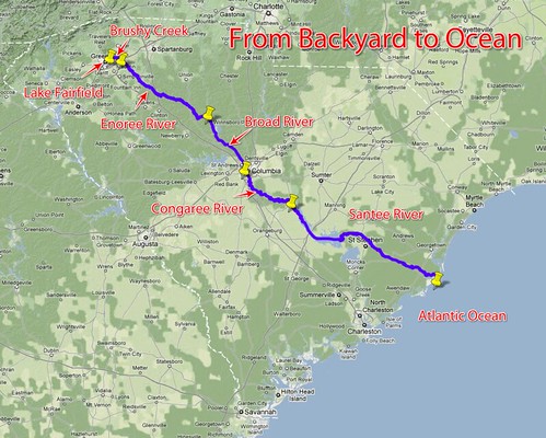
Backyard2Ocean

Last night Laura and I were sitting out on our deck look out over the backyard and down to the lake. I wondered what would happen if I were to put my kayak in the water here and paddle it all the way to the ocean. What would I encounter? What rivers would I paddle?

Actually, I’ve got a pretty darn good idea. I’ve paddled and/or explored some sizeable chunks of that route, so I know a bit about it. My paddle route would take this path…

Lake Fairfield –> Brushy Creek –> Enoree River –> Broad River –> Congaree River –> Santee River –> Atlantic Ocean

I’d love to be able to do that whole route without ever having to leave the boat. Unfortunately, there are a few things like shoals, trees, strainers, and a few dams in the way, not to mention Parr Shoals Reservoir and Lake Marion.

Read More “From Backyard to Ocean” »

Greenville Historical Aerial Imagery

Posted on April 5, 2011 By Tom 3 Comments on Greenville Historical Aerial Imagery
History and Genealogy, Internet, Local

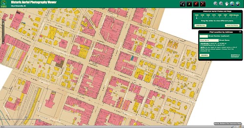
Downtown Sanford 1920

Sometime last week the Greenville Cageliner had an article about a new website from the Greenville County GIS Office (http://gis.greenvillesc.gov/historicalimagery/). The website features historical aerial photography imagery as a map, similar to Google Earth. Images are available for 1955, 1965, 1979, 1989, 1997, and 2009, and cover the downtown area, along with a bit of the county. Also included is the Sanford Insurance Map of the city from 1920.

I could spend a HUGE amount of time exploring the site. Looking at how the city has changed over the decades has been fascinating, and somewhat depressing. The patterns of urban sprawl are quite clear at a distance, and it can be sad to look back on landmarks that are no longer there. On the other hand, there have been some marked improvements in areas such as along the banks of the Reedy River, and these images show that very clearly.

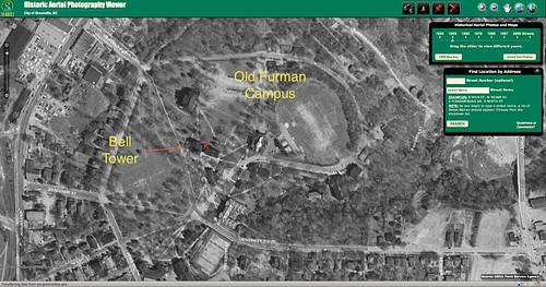
I started with the area around the old Furman campus. I had never really understood the location of the old bell tower in relation to the rest of the campus, but this imagery makes it very clear. (Click on the images for a larger view.)

Old Furman Campus 1955

Read More “Greenville Historical Aerial Imagery” »

US 1

Posted on March 23, 2010 By Tom 10 Comments on US 1
Geocaching and Maps

When I was about 12 years old my brother-in-law gave me a Rand McNally Road Atlas. I had already been collecting maps for some time, so having an atlas with a map of every state in the US was a dream come true. I pored over every state, plotting out extended road trips.

One road that especially caught my attention was US 1. First, there was its primacy in the numerical highway system. It must be important if it’s number 1. Then, there was the route. It runs all the way from Key West, Florida, to the northernmost point in Fort Kent, Maine. And finally, there were all of the interesting cities that it connected – places I’d never been, such as Washington, D. C., Philadelphia, New York, and Boston. It seemed like the perfect highway to me.

Recently I’ve had the occasion to drive different segments of US 1 – in Columbia last week, in Florida two weeks ago, and in Maine over this past summer. The recent jaunts on this highway rekindled my interest, so I started exploring the route in Google Earth, and trying to find out what I could about its history.

Read More “US 1” »

DARPA Challenge Update

Posted on December 6, 2009 By Tom 1 Comment on DARPA Challenge Update
Geocaching and Maps, Internet

Well, that didn’t take long. By 5:00 PM DARPA had already announced a winner in their 2009 Challenge. The challenge was supposed to last through December 14, but it was obvious from early on that it wouldn’t take that much time. As shown on the map above, the balloons were located in places where it would have been hard to miss them (although there is a large wedge of the Midwest with no ballooons.) The winner was the team from MIT.

I didn’t participate in the challenge as I thought I might. However, I did check in on the progress from time-to-time on Twitter. It was interesting to watch the competition progress. Most of the Twitter traffic seemed to be from those involved in the hunt, and I saw only one from someone that seemed to have honestly stumbled upon one (…sort of, but more on that in a bit.)

As I saw reports of balloons I wondered if I shouldn’t try to find the location and report them as my own. However, I figured that if the reports were THAT public, then others would have reported them. I just decided to watch the spectacle.

Read More “DARPA Challenge Update” »

99 Red Balloons

Posted on December 4, 2009 By Tom 2 Comments on 99 Red Balloons
Internet, Weirdness

You and I in a little toy shop,
Buy a bag of balloons with the money we’ve got.
Set them free at the break of dawn
‘Til one by one, they were gone…

Actually, it’s 99 minus 89, but references to the 1980’s hit by Nena are inevitable. To celebrate the 40th anniversary of the Internet, DARPA has come up with a creative challenge “that will explore the roles the Internet and social networking play in the timely communication, wide-area team-building, and urgent mobilization required to solve broad-scope, time-critical problems.”

According to the challenge website ten red, eight-foot weather balloons will be tethered to locations around the United States. The first person (or team) to provide the latitude and longitude of all balloons will win a $40,000 prize.

CNN.com quotes Johanna Jones, a spokeswoman for DARPA, and provides a few more details…

At 10 a.m. ET, the 8-foot-wide red weather balloons will be released on property accessible to the public.

“They’re not going to be out in the middle of nowhere,” Jones said. “They’re going to be near places where there is traffic.”

She said the balloons will be tethered and will remain aloft for at least six hours. Each will be accompanied by a DARPA representative.

The first person to report the latitude and longitude coordinates of all 10 balloons will win the prize. The competition will remain open until December 14.

Nationwide balloon-hunt contest tests online networking
By Doug Gross, CNN
December 4, 2009

So, the balloons will only be aloft for a few hours on one day. That means no individual could travel to all 10 locations. Seekers will be forced to search for references to the balloons and reports in social media such as Twitter, Facebook, or Flickr. That is, of course, assuming someone reports the sighting and is willing to provide coordinates. If I didn’t already know about the challenge, I doubt I would stop and Tweet about a red balloon, giving its lat/long coordinates.
Read More “99 Red Balloons” »

Paddling South Carolina’s Rivers

Posted on October 28, 2009 By Tom 22 Comments on Paddling South Carolina’s Rivers
Geocaching and Maps, Paddling

South Carolina Rivers

File – Paddling South Carolina Rivers (KMZ, 1.5 MB)

Google Earth has been one of the best resources for planning river kayaking trips, especially on new routes with which I’m not familiar. I’ll scan the route, locate put-in and take-out points, and put placemarks for certain landmarks such as rapids, powerlines, bridges, tributaries, or other interesting locations along the way. I would then use GPS Babel to convert my Google Earth files to GPX files then upload the data to my GPS so I would have it with me on the paddling trip.

Pretty soon I had a nice little collection of river trips in Google Earth. I began to wonder if anyone else was doing this. It seemed like it would be an excellent resource. There are some excellent books out there, such as Able and Horman’s Paddling South Carolina, and while the maps in these resources are fine for giving driving directions, there is no GPS information. SCTrails.net has started putting Lat/Long coordinates for some of their paddling trails, but not for all of them. So, I decided to make my own collection.

Read More “Paddling South Carolina’s Rivers” »

Getting More from Your Auto GPS

Posted on April 17, 2009 By Tom 2 Comments on Getting More from Your Auto GPS
Gear, Geocaching and Maps

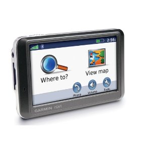
I figured it was time for a round-up.  I’ve been talking a lot about doing various things with a GPS, but haven’t gone into much detail.  Chances are that you got a GPS for your car because you feel like you’re directionally challenged, or you just the convenience of plugging in an address and getting directions.  That’s about the extent of what most people do, but there is so much more.

Thought it might be time to talk about automobile GPSs in general, and how they can really benefit a serious rambler like myself.  The one I use is a Garmin Nuvi 205, but most of what I’ll cover here should work with just about any unit.  If you’re into geocaching, you’ll already be familiar with most of these concepts.

Read More “Getting More from Your Auto GPS” »

More Disc Golf Resources

Posted on February 9, 2009 By Tom No Comments on More Disc Golf Resources
Entertainment, Geocaching and Maps

I realized that in yesterday’s post I didn’t get any maps or locations to the two disc golf courses I’d played.  The easiest thing would be to see if the Upstate Disc Golf Club website had links to maps on their course list, but there were not even any written directions. I thought I had … Read More “More Disc Golf Resources” »

Geohashing – A Game Based on a Comic

Posted on January 27, 2009 By Tom 6 Comments on Geohashing – A Game Based on a Comic
Geocaching and Maps

null

The XKCD comic seen above came out around Christmas of 2006, and formed the basis for a new GPS activity – not necessarily going to a random location and making out, but using random numbers to generate latitude and longitude coordinates.  The process of generating the random coordinates is called Geohashing.  These coordinates serve as a basis for adventure, not unlike throwing a dart on a map and then trying to reach that location.  It’s a lot like Geocaching, but you don’t have to find a little container, and the coordinates change.

Read More “Geohashing – A Game Based on a Comic” »

Posts pagination

Previous 1 2 3 Next

Categories

  • EdTech (197)
  • Entertainment (202)
  • Family (123)
  • Gear (114)
  • General Technology (98)
  • Geocaching and Maps (208)
  • History and Genealogy (275)
  • Internet (142)
  • Local (459)
  • Miscellaneous (560)
  • Music (202)
  • Paddling (268)
  • Photography (781)
  • Podcast (19)
  • Rambling (233)
  • Rants (162)
  • Recipes (37)
  • Religion (48)
  • Restaurants (165)
  • Science (48)
  • Things Overheard (29)
  • Travel (413)
  • Uncategorized (143)
  • Washington Sabbatical (113)
  • Weirdness (61)

Recent Posts

  • Helene One Year Later
  • Once Again, Up the Long Nose
  • Upstate Renaissance Faire
  • Exploring Lake Summit
  • The End of Days

Recent Comments

  • Gay on In Search of the Road Builder
  • Virgil Howell on The Ghost Towns of Lake Marion
  • Virgil Howell on Return to Ferguson
  • Mary Copeland Myers on Renno and Stomp Springs
  • Virginia Pepper on Helene One Year Later

Tags

blogging cemetery Christmas Columbia Edisto River edtech Entertainment family Flickr Florida Furman Furman University gear Georgia geotagging Ghost Town Ghost Towns Google Earth Google Maps GPS Greenville Greenville Chorale history Instructional Technology kayaking Lake Jocassee LCU Lowcountry Unfiltered maps Music North Carolina Paddling Photography rambling restaurant Restaurants review singing social networking South Carolina time-lapse Travel video Washington Washington State
October 2025
S M T W T F S
 1234
567891011
12131415161718
19202122232425
262728293031  
« Sep    

Copyright © 2025 Random Connections.

Theme: Oceanly by ScriptsTown