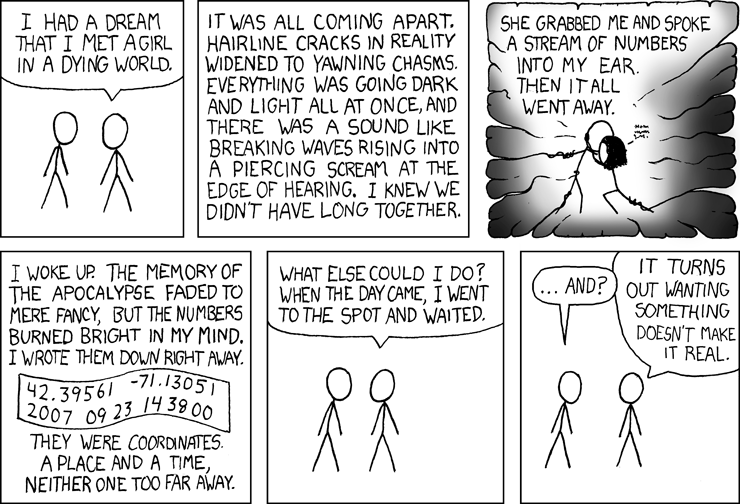
The XKCD comic seen above came out around Christmas of 2006, and formed the basis for a new GPS activity – not necessarily going to a random location and making out, but using random numbers to generate latitude and longitude coordinates. The process of generating the random coordinates is called Geohashing. These coordinates serve as a basis for adventure, not unlike throwing a dart on a map and then trying to reach that location. It’s a lot like Geocaching, but you don’t have to find a little container, and the coordinates change.
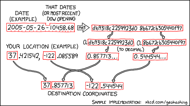
I recently came across the term in a friend’s “25 Things About Me” meme on their Facebook page, and it intrigued me. XKCD took the original idea from the 2006 comic and expanded it in May of 2008 with the following:
While initially meant as a joke – a rhyming play on the word “geocaching,” it turned out to be a pretty good algorithm for creating random locations.
First you start with a 1°Ã—1° latitude/longitude zone (known as a graticule) anywhere in the world. In our case it would be 34° N X 82°W. Take the today’s date and concatenate it with the last Dow Jones Average opening with dashes, then run it through an MD5 cryptography engine. This produces a 32-bit hexidecimal hash function that can be split in half. The resulting 16 digit hex numbers can be reconverted back into base-ten decimals then added to the graticule numbers to create the new coordinates.
And just in case you had trouble following all of that, or if you have problems doing MD5 encryption in your head, XKCD has created an easy online random location generator for you. Just select the day, then zoom into the region that contains your graticule, and the location is randomly generated for you.
…pseudo-randomly generated, I should say. Since it’s based an a single daily data point (stock market average), the location for each graticule will be the same for everyone for that particular day. This makes the geohash a great tool for random meet-ups for larger groups of people (provided, of course, that they are geeky enough to find it.) You might also note that every possible geohash is separated by exactly 1° of latitude and longitude.
Of course, since this is random it’s highly likely that the coordinates are going to be on private property or in the middle of a lake. The XKCD wiki has lots of disclaimers about trespassing or going into dangerous areas. I guess you could designate the “nearest public location to…” as your destination.
So, if I leave my office right now and headed to today’s geohash, you might find me here:
And I’ll leave XKCD with the final word on random locations:


That’s pretty interesting. I like the idea of the original comic, where you could put your own importance on a specific location.
I didn’t realize Watts was so close to Abbeville.
Given the title of your blog, this seems right up your alley.
I just joined the GPS revolution and have thought about trying the Geocaching (there are a couple in Hitchcock Woods, our favorite walking spot), but this sounds interesting too. I wonder if we would stumble on someone there for the same reason…
Was it my facebook? I think I’m the only one who geohashes around here…
Yep, it was your blasted 25 Things meme 😉 I saw the term and was intrigued.
Oh, and lots of points end up in the no mans land down below Belton and that area. I’ve been to Calhoun Falls before chasing a Geohash.